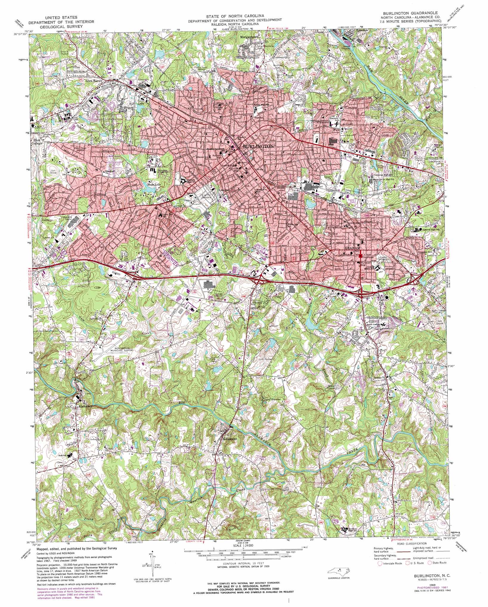
Burlington Topo Map North Carolina
To zoom in, hover over the map of Burlington
USGS Topo Quad 36079a4 - 1:24,000 scale
| Topo Map Name: | Burlington |
| USGS Topo Quad ID: | 36079a4 |
| Print Size: | ca. 21 1/4" wide x 27" high |
| Southeast Coordinates: | 36° N latitude / 79.375° W longitude |
| Map Center Coordinates: | 36.0625° N latitude / 79.4375° W longitude |
| U.S. State: | NC |
| Filename: | o36079a4.jpg |
| Download Map JPG Image: | Burlington topo map 1:24,000 scale |
| Map Type: | Topographic |
| Topo Series: | 7.5´ |
| Map Scale: | 1:24,000 |
| Source of Map Images: | United States Geological Survey (USGS) |
| Alternate Map Versions: |
Burlington NC 1969, updated 1972 Download PDF Buy paper map Burlington NC 1969, updated 1982 Download PDF Buy paper map Burlington NC 1980, updated 1983 Download PDF Buy paper map Burlington NC 2010 Download PDF Buy paper map Burlington NC 2013 Download PDF Buy paper map Burlington NC 2016 Download PDF Buy paper map |
1:24,000 Topo Quads surrounding Burlington
Reidsville |
Williamsburg |
Cherry Grove |
Anderson |
Ridgeville |
Browns Summit |
Ossipee |
Lake Burlington |
Burlington Ne |
Cedar Grove |
Mcleansville |
Gibsonville |
Burlington |
Mebane |
Efland |
Climax |
Kimesville |
Snow Camp |
Saxapahaw |
White Cross |
Grays Chapel |
Liberty |
Crutchfield Crossroads |
Silk Hope |
Bynum |
> Back to 36079a1 at 1:100,000 scale
> Back to 36078a1 at 1:250,000 scale
> Back to U.S. Topo Maps home
Burlington topo map: Gazetteer
Burlington: Airports
Burlington Municipal Airport elevation 187m 613′Burlington: Dams
Mays Lake Dam elevation 182m 597′Shamrock Golf Course Lake Dam elevation 163m 534′
Snoffers Lake Dam elevation 190m 623′
Burlington: Parks
Fairchild Park elevation 195m 639′Graham Municipal Park elevation 166m 544′
North Park elevation 179m 587′
Oakdale Town and Country Park elevation 157m 515′
Oakley Street Park elevation 187m 613′
Robinson Park elevation 191m 626′
Sellars Memorial Park elevation 195m 639′
Burlington: Populated Places
Alamance elevation 169m 554′Alamance Acres elevation 200m 656′
Alamance Hills Subdivision elevation 183m 600′
Avalon Valley elevation 167m 547′
Bellemont elevation 169m 554′
Beverly Hills elevation 175m 574′
Broad Acres elevation 178m 583′
Brookwood Subdivision elevation 196m 643′
Burlington elevation 198m 649′
Cedar Crest elevation 182m 597′
Central Heights elevation 200m 656′
Country Club Estates elevation 184m 603′
Country Club Forest elevation 201m 659′
Crestwood elevation 199m 652′
Dogwood Acres elevation 197m 646′
Fairchild Heights Subdivision elevation 167m 547′
Forest Hills elevation 171m 561′
Forest Valley Mobile Home Subdivision elevation 175m 574′
Glen Raven elevation 213m 698′
Graber Heights elevation 189m 620′
Graham elevation 194m 636′
Greenbrier elevation 199m 652′
Grove Park elevation 198m 649′
Hopedale elevation 168m 551′
Hunting Hills elevation 181m 593′
Jackson Park elevation 198m 649′
Kellam Place elevation 182m 597′
Knollwood elevation 192m 629′
Lakeside elevation 193m 633′
Lee Acres elevation 198m 649′
Longview Acres elevation 198m 649′
Maple Grove Acres elevation 173m 567′
Martindale Acres elevation 167m 547′
Morgantown elevation 194m 636′
Northwood elevation 180m 590′
Overland Heights elevation 188m 616′
Pickwood Hills elevation 177m 580′
Piedmont Heights elevation 181m 593′
Pinewood Acres elevation 190m 623′
Pinewood Forest elevation 195m 639′
Quail Hollow elevation 177m 580′
Red Oak Acres elevation 207m 679′
Rockwood elevation 174m 570′
Rockwood Acres elevation 196m 643′
Sherwood Forest elevation 196m 643′
Spring Valley elevation 194m 636′
Sunset Acres elevation 197m 646′
The Farm elevation 163m 534′
Turrentine Estates elevation 188m 616′
Wedgewood West elevation 200m 656′
Westerwood elevation 196m 643′
Woodshire Estates elevation 170m 557′
Burlington: Reservoirs
Gant Lake elevation 197m 646′Mays Lake elevation 182m 597′
Shamrock Golf Course Lake elevation 163m 534′
Snoffers Lake elevation 190m 623′
Burlington: Streams
Back Creek elevation 151m 495′Bowden Branch elevation 155m 508′
Boyds Creek elevation 150m 492′
Gum Creek elevation 145m 475′
Little Alamance Creek elevation 143m 469′
North Prong Stinking Quarter Creek elevation 152m 498′
Rock Creek elevation 146m 479′
Service Creek elevation 152m 498′
South Prong Stinking Quarter Creek elevation 152m 498′
Staley Creek elevation 164m 538′
Stinking Quarter Creek elevation 145m 475′
Stony Creek elevation 153m 501′
Burlington digital topo map on disk
Buy this Burlington topo map showing relief, roads, GPS coordinates and other geographical features, as a high-resolution digital map file on DVD:
Western Virginia & Southern West Virginia
Buy digital topo maps: Western Virginia & Southern West Virginia