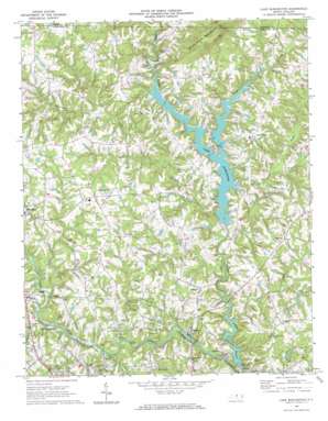
Lake Burlington Topo Map North Carolina
To zoom in, hover over the map of Lake Burlington
USGS Topo Quad 36079b4 - 1:24,000 scale
| Topo Map Name: | Lake Burlington |
| USGS Topo Quad ID: | 36079b4 |
| Print Size: | ca. 21 1/4" wide x 27" high |
| Southeast Coordinates: | 36.125° N latitude / 79.375° W longitude |
| Map Center Coordinates: | 36.1875° N latitude / 79.4375° W longitude |
| U.S. State: | NC |
| Filename: | o36079b4.jpg |
| Download Map JPG Image: | Lake Burlington topo map 1:24,000 scale |
| Map Type: | Topographic |
| Topo Series: | 7.5´ |
| Map Scale: | 1:24,000 |
| Source of Map Images: | United States Geological Survey (USGS) |
| Alternate Map Versions: |
Lake Burlington NC 1969, updated 1972 Download PDF Buy paper map Lake Burlington NC 1969, updated 1972 Download PDF Buy paper map Lake Burlington NC 2010 Download PDF Buy paper map Lake Burlington NC 2013 Download PDF Buy paper map Lake Burlington NC 2016 Download PDF Buy paper map |
1:24,000 Topo Quads surrounding Lake Burlington
> Back to 36079a1 at 1:100,000 scale
> Back to 36078a1 at 1:250,000 scale
> Back to U.S. Topo Maps home
Lake Burlington topo map: Gazetteer
Lake Burlington: Dams
Lake Burlington Sediment Pool Number One Dam elevation 185m 606′Lake Burlington Sediment Pool Number Two Dam elevation 181m 593′
Lake Cammack Dam elevation 164m 538′
Lake View Estates Pond Dam elevation 183m 600′
Old Stony Creek Dam elevation 163m 534′
Lake Burlington: Populated Places
Birchwood elevation 182m 597′British Acres elevation 182m 597′
Carolina elevation 178m 583′
Clover Garden elevation 211m 692′
Glencoe elevation 176m 577′
Green Acres elevation 194m 636′
Lakeview elevation 197m 646′
Lakeview Estates elevation 188m 616′
McCray elevation 200m 656′
Union Ridge elevation 207m 679′
Lake Burlington: Reservoirs
Lake Burlington elevation 175m 574′Lake Burlington Sediment Pool elevation 185m 606′
Lake Burlington Sediment Pool Number Two elevation 181m 593′
Lake Cammack elevation 164m 538′
Lake View Estates Pond elevation 183m 600′
Stony Creek Reservoir elevation 159m 521′
Lake Burlington: Streams
Buttermilk Creek elevation 164m 538′Deep Creek elevation 164m 538′
Jordan Creek elevation 165m 541′
Owens Creek elevation 169m 554′
Toms Creek elevation 176m 577′
Travis Creek elevation 172m 564′
Lake Burlington: Summits
Stony Creek Mountain elevation 277m 908′Lake Burlington digital topo map on disk
Buy this Lake Burlington topo map showing relief, roads, GPS coordinates and other geographical features, as a high-resolution digital map file on DVD:
Western Virginia & Southern West Virginia
Buy digital topo maps: Western Virginia & Southern West Virginia


