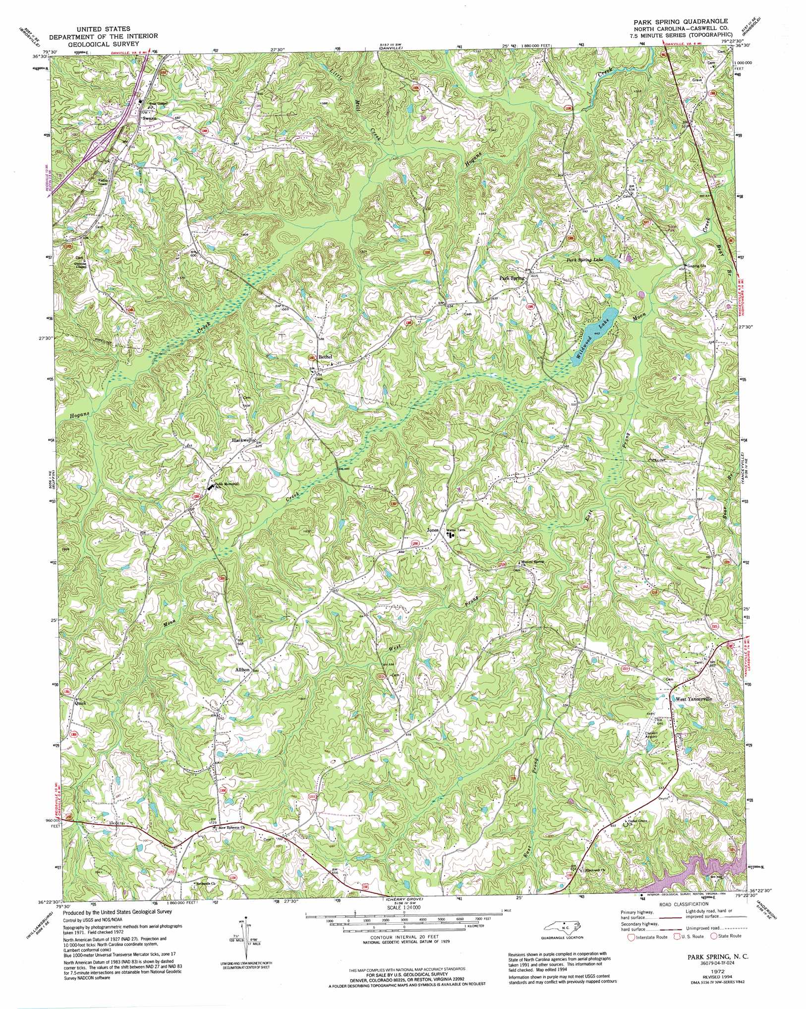
Park Spring Topo Map North Carolina
To zoom in, hover over the map of Park Spring
USGS Topo Quad 36079d4 - 1:24,000 scale
| Topo Map Name: | Park Spring |
| USGS Topo Quad ID: | 36079d4 |
| Print Size: | ca. 21 1/4" wide x 27" high |
| Southeast Coordinates: | 36.375° N latitude / 79.375° W longitude |
| Map Center Coordinates: | 36.4375° N latitude / 79.4375° W longitude |
| U.S. State: | NC |
| Filename: | o36079d4.jpg |
| Download Map JPG Image: | Park Spring topo map 1:24,000 scale |
| Map Type: | Topographic |
| Topo Series: | 7.5´ |
| Map Scale: | 1:24,000 |
| Source of Map Images: | United States Geological Survey (USGS) |
| Alternate Map Versions: |
Park Spring NC 1972, updated 1974 Download PDF Buy paper map Park Spring NC 1972, updated 1990 Download PDF Buy paper map Park Spring NC 1972, updated 1994 Download PDF Buy paper map Park Spring NC 2002, updated 2002 Download PDF Buy paper map Park Spring NC 2010 Download PDF Buy paper map Park Spring NC 2013 Download PDF Buy paper map Park Spring NC 2016 Download PDF Buy paper map |
1:24,000 Topo Quads surrounding Park Spring
Axton |
Whitmell |
Mount Hermon |
Blairs |
Ingram |
Northeast Eden |
Brosville |
Danville |
Ringgold |
Milton |
Southeast Eden |
Ruffin |
Park Spring |
Yanceyville |
Leasburg |
Reidsville |
Williamsburg |
Cherry Grove |
Anderson |
Ridgeville |
Browns Summit |
Ossipee |
Lake Burlington |
Burlington Ne |
Cedar Grove |
> Back to 36079a1 at 1:100,000 scale
> Back to 36078a1 at 1:250,000 scale
> Back to U.S. Topo Maps home
Park Spring topo map: Gazetteer
Park Spring: Airports
Caswell Airpark elevation 194m 636′Park Spring: Dams
Wildwood Lake Dam elevation 134m 439′Park Spring: Populated Places
Allison elevation 207m 679′Bethel elevation 184m 603′
Blackwell elevation 191m 626′
Jones elevation 196m 643′
Park Spring elevation 186m 610′
Quick elevation 202m 662′
Swann elevation 223m 731′
West Yanceyville elevation 194m 636′
Park Spring: Reservoirs
Park Spring Lake elevation 135m 442′Wildwood Lake elevation 134m 439′
Park Spring: Streams
Bear Branch elevation 127m 416′East Prong Moon Creek elevation 131m 429′
Little Mill Creek elevation 129m 423′
West Prong Moon Creek elevation 145m 475′
Park Spring digital topo map on disk
Buy this Park Spring topo map showing relief, roads, GPS coordinates and other geographical features, as a high-resolution digital map file on DVD:
Western Virginia & Southern West Virginia
Buy digital topo maps: Western Virginia & Southern West Virginia