Northeast Eden Topo Map Virginia
To zoom in, hover over the map of Northeast Eden
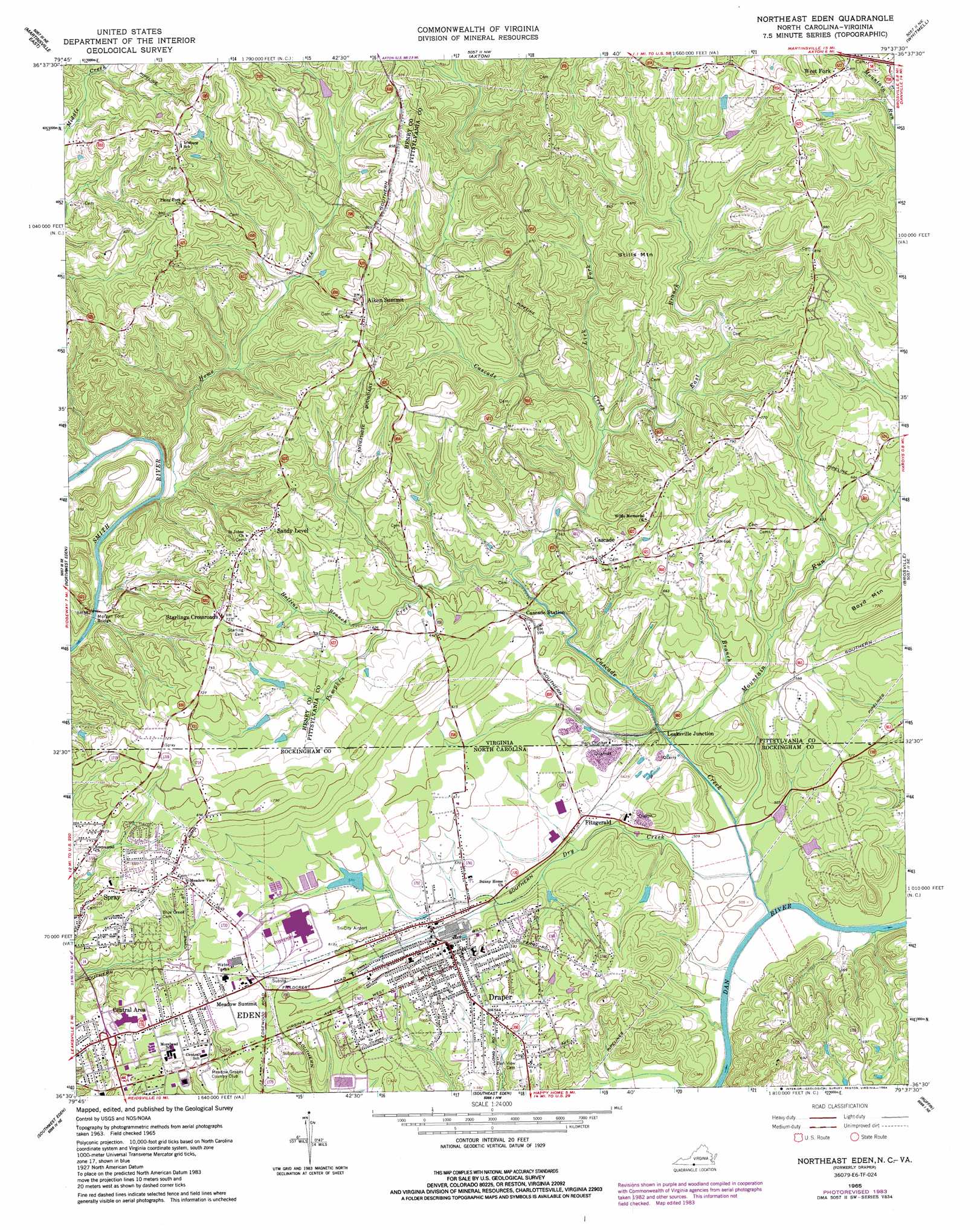
USGS Topo Quad 36079e6 - 1:24,000 scale
| Topo Map Name: | Northeast Eden |
| USGS Topo Quad ID: | 36079e6 |
| Print Size: | ca. 21 1/4" wide x 27" high |
| Southeast Coordinates: | 36.5° N latitude / 79.625° W longitude |
| Map Center Coordinates: | 36.5625° N latitude / 79.6875° W longitude |
| U.S. States: | VA, NC |
| Filename: | o36079e6.jpg |
| Download Map JPG Image: | Northeast Eden topo map 1:24,000 scale |
| Map Type: | Topographic |
| Topo Series: | 7.5´ |
| Map Scale: | 1:24,000 |
| Source of Map Images: | United States Geological Survey (USGS) |
| Alternate Map Versions: |
Draper NC 1965, updated 1966 Download PDF Buy paper map Northeast Eden NC 1965, updated 1979 Download PDF Buy paper map Northeast Eden NC 1965, updated 1984 Download PDF Buy paper map Northeast Eden NC 1965, updated 1984 Download PDF Buy paper map Northeast Eden NC 1997, updated 2000 Download PDF Buy paper map Northeast Eden NC 2011 Download PDF Buy paper map Northeast Eden NC 2013 Download PDF Buy paper map Northeast Eden NC 2016 Download PDF Buy paper map |
1:24,000 Topo Quads surrounding Northeast Eden
Bassett |
Snow Creek |
Mountain Valley |
Callands |
Chatham |
Martinsville West |
Martinsville East |
Axton |
Whitmell |
Mount Hermon |
Price |
Northwest Eden |
Northeast Eden |
Brosville |
Danville |
Mayodan |
Southwest Eden |
Southeast Eden |
Ruffin |
Park Spring |
Ellisboro |
Bethany |
Reidsville |
Williamsburg |
Cherry Grove |
> Back to 36079e1 at 1:100,000 scale
> Back to 36078a1 at 1:250,000 scale
> Back to U.S. Topo Maps home
Northeast Eden topo map: Gazetteer
Northeast Eden: Bridges
Morgan Ford Bridge elevation 182m 597′Northeast Eden: Dams
Wells Dam elevation 252m 826′Northeast Eden: Populated Places
Aiken Summit elevation 254m 833′Cascade elevation 209m 685′
Central Area elevation 198m 649′
Creekridge elevation 186m 610′
Draper (historical) elevation 176m 577′
Fitzgerald elevation 168m 551′
Grand Oaks elevation 202m 662′
Green Acres elevation 175m 574′
Leaksville Junction elevation 165m 541′
Meadow Summit elevation 195m 639′
Northridge elevation 221m 725′
Rickman Acres elevation 180m 590′
Sandy Level elevation 242m 793′
Starlings Crossroads elevation 228m 748′
West Fork elevation 279m 915′
Northeast Eden: Streams
Cascade Creek elevation 144m 472′Cascade Creek elevation 144m 472′
Cow Branch elevation 165m 541′
Dry Creek elevation 151m 495′
East Branch Cascade Creek elevation 189m 620′
Hollins Branch elevation 177m 580′
Home Creek elevation 193m 633′
Lick Fork elevation 194m 636′
Mountain Run elevation 159m 521′
Mountain Run elevation 156m 511′
Pumpkin Creek elevation 177m 580′
Northeast Eden: Summits
Stills Mountain elevation 281m 921′Northeast Eden digital topo map on disk
Buy this Northeast Eden topo map showing relief, roads, GPS coordinates and other geographical features, as a high-resolution digital map file on DVD:
Western Virginia & Southern West Virginia
Buy digital topo maps: Western Virginia & Southern West Virginia