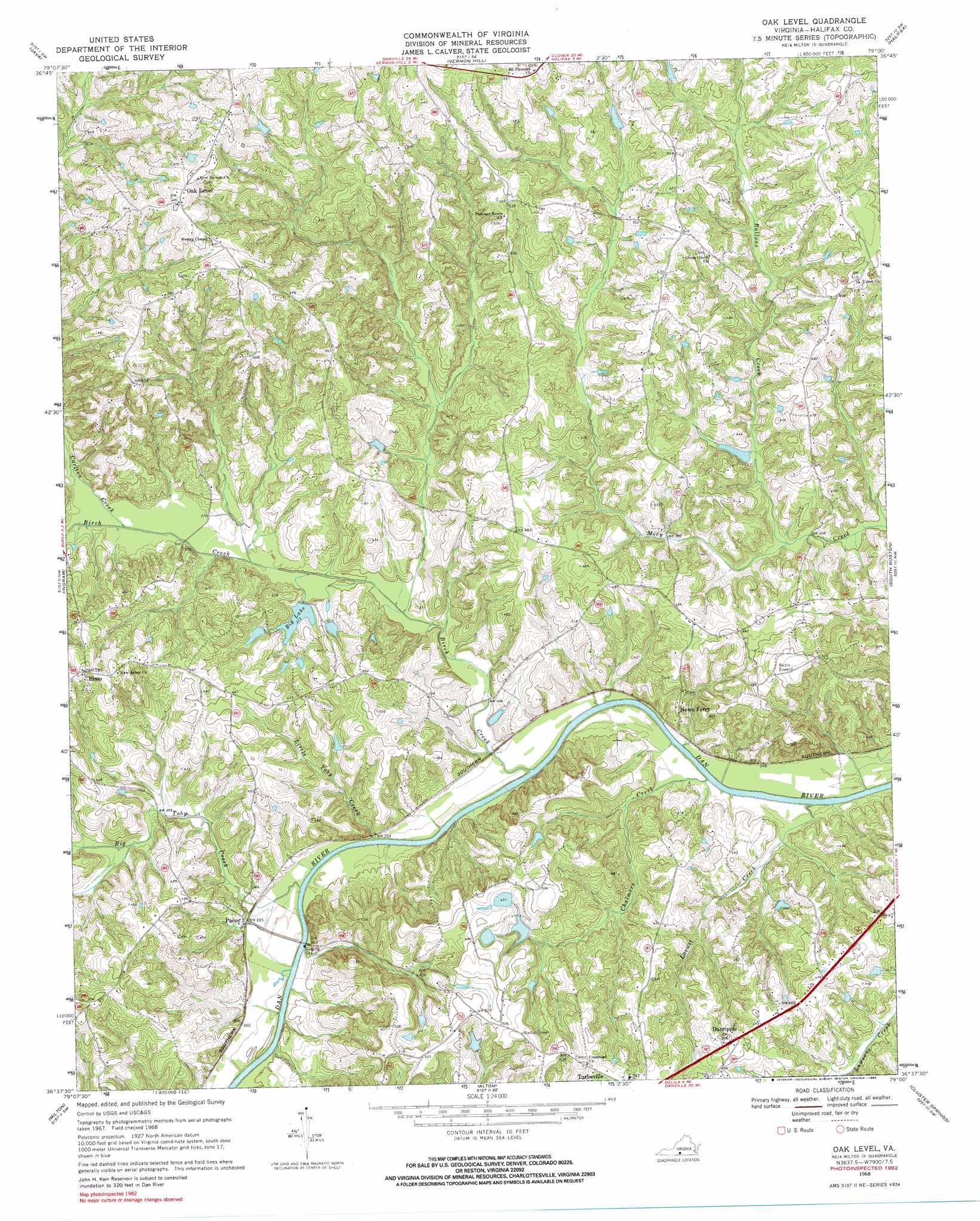
Oak Level Topo Map Virginia
To zoom in, hover over the map of Oak Level
USGS Topo Quad 36079f1 - 1:24,000 scale
| Topo Map Name: | Oak Level |
| USGS Topo Quad ID: | 36079f1 |
| Print Size: | ca. 21 1/4" wide x 27" high |
| Southeast Coordinates: | 36.625° N latitude / 79° W longitude |
| Map Center Coordinates: | 36.6875° N latitude / 79.0625° W longitude |
| U.S. State: | VA |
| Filename: | o36079f1.jpg |
| Download Map JPG Image: | Oak Level topo map 1:24,000 scale |
| Map Type: | Topographic |
| Topo Series: | 7.5´ |
| Map Scale: | 1:24,000 |
| Source of Map Images: | United States Geological Survey (USGS) |
| Alternate Map Versions: |
Oak Level VA 1968, updated 1972 Download PDF Buy paper map Oak Level VA 1968, updated 1985 Download PDF Buy paper map Oak Level VA 2011 Download PDF Buy paper map Oak Level VA 2013 Download PDF Buy paper map Oak Level VA 2016 Download PDF Buy paper map |
1:24,000 Topo Quads surrounding Oak Level
Gretna |
Mount Airy |
Republican Grove |
Nathalie |
Conner Lake |
Spring Garden |
Java |
Vernon Hill |
Halifax |
Scottsburg |
Blairs |
Ingram |
Oak Level |
South Boston |
Omega |
Ringgold |
Milton |
Alton |
Cluster Springs |
Virgilina |
Yanceyville |
Leasburg |
Olive Hill |
Roxboro |
Triple Springs |
> Back to 36079e1 at 1:100,000 scale
> Back to 36078a1 at 1:250,000 scale
> Back to U.S. Topo Maps home
Oak Level topo map: Gazetteer
Oak Level: Bars
Ruddy Bottom Shoals elevation 100m 328′Oak Level: Dams
Bass Dam elevation 128m 419′East Temple Dam elevation 118m 387′
Five Oaks Dam elevation 178m 583′
Fye Dam elevation 128m 419′
Oakes Dam elevation 114m 374′
Ragland Dam elevation 151m 495′
Temple Dam elevation 113m 370′
Wade Dam Number Four elevation 155m 508′
Wade Dam Number One elevation 143m 469′
Wade Dam Number Three elevation 143m 469′
Wade Dam Number Two elevation 135m 442′
West Temple Dam elevation 121m 396′
Oak Level: Populated Places
Bosses elevation 174m 570′Danripple elevation 153m 501′
Elmo elevation 170m 557′
Jones elevation 161m 528′
Owens Store elevation 134m 439′
Paces elevation 108m 354′
Pleasant Grove elevation 165m 541′
Terrys Corner elevation 132m 433′
Oak Level: Reservoirs
Big Lake elevation 114m 374′Five Oaks Pond elevation 178m 583′
Temple Pond elevation 113m 370′
Oak Level: Streams
Ballous Creek elevation 107m 351′Big Toby Creek elevation 100m 328′
Birch Creek elevation 100m 328′
Carlton Creek elevation 109m 357′
Chalmers Creek elevation 100m 328′
Little Toby Creek elevation 100m 328′
Locust Creek elevation 100m 328′
Oak Level digital topo map on disk
Buy this Oak Level topo map showing relief, roads, GPS coordinates and other geographical features, as a high-resolution digital map file on DVD:
Western Virginia & Southern West Virginia
Buy digital topo maps: Western Virginia & Southern West Virginia