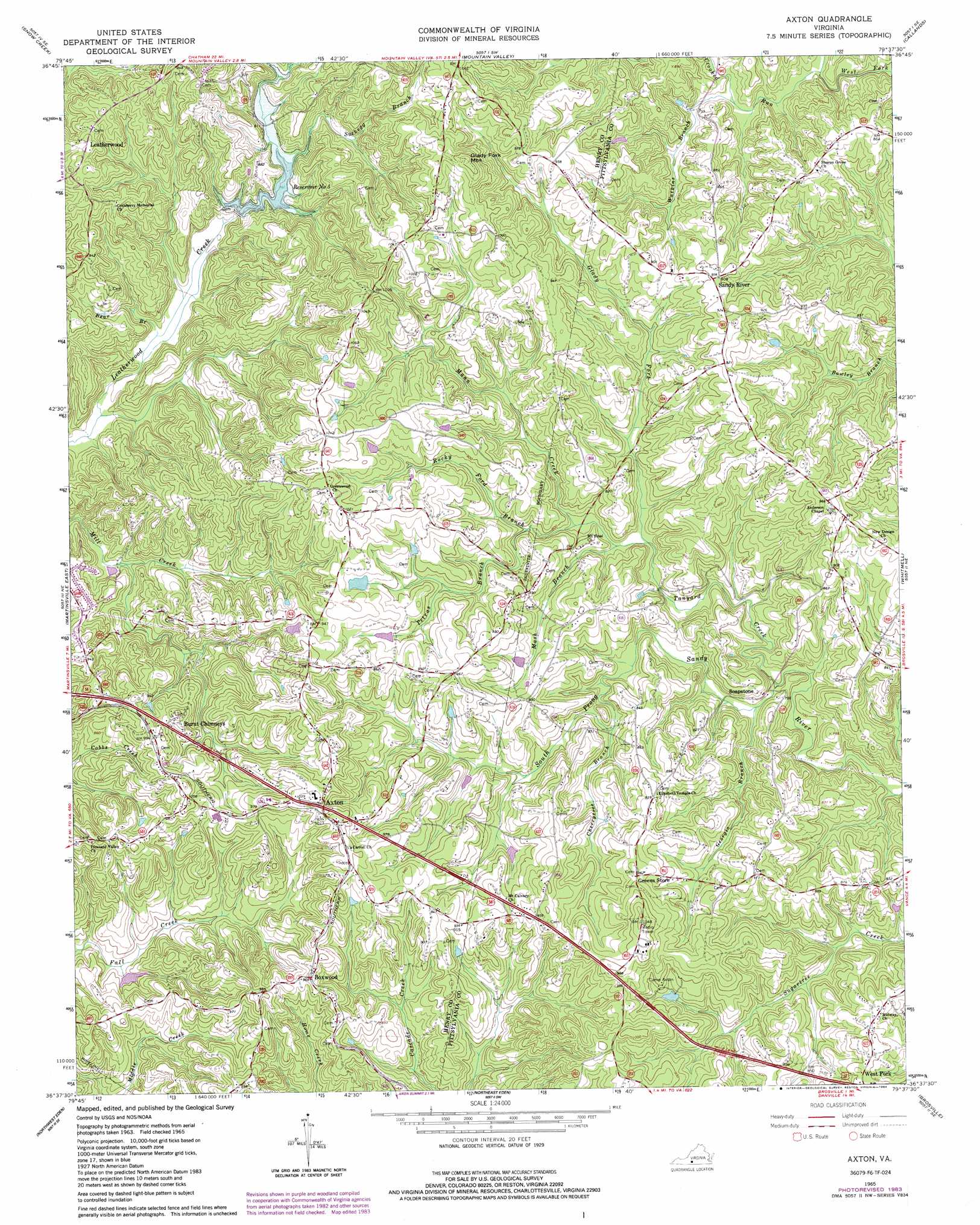
Axton Topo Map Virginia
To zoom in, hover over the map of Axton
USGS Topo Quad 36079f6 - 1:24,000 scale
| Topo Map Name: | Axton |
| USGS Topo Quad ID: | 36079f6 |
| Print Size: | ca. 21 1/4" wide x 27" high |
| Southeast Coordinates: | 36.625° N latitude / 79.625° W longitude |
| Map Center Coordinates: | 36.6875° N latitude / 79.6875° W longitude |
| U.S. State: | VA |
| Filename: | o36079f6.jpg |
| Download Map JPG Image: | Axton topo map 1:24,000 scale |
| Map Type: | Topographic |
| Topo Series: | 7.5´ |
| Map Scale: | 1:24,000 |
| Source of Map Images: | United States Geological Survey (USGS) |
| Alternate Map Versions: |
Axton VA 1965, updated 1966 Download PDF Buy paper map Axton VA 1965, updated 1984 Download PDF Buy paper map Axton VA 2011 Download PDF Buy paper map Axton VA 2013 Download PDF Buy paper map Axton VA 2016 Download PDF Buy paper map |
1:24,000 Topo Quads surrounding Axton
Rocky Mount |
Gladehill |
Penhook |
Sandy Level |
Pittsville |
Bassett |
Snow Creek |
Mountain Valley |
Callands |
Chatham |
Martinsville West |
Martinsville East |
Axton |
Whitmell |
Mount Hermon |
Price |
Northwest Eden |
Northeast Eden |
Brosville |
Danville |
Mayodan |
Southwest Eden |
Southeast Eden |
Ruffin |
Park Spring |
> Back to 36079e1 at 1:100,000 scale
> Back to 36078a1 at 1:250,000 scale
> Back to U.S. Topo Maps home
Axton topo map: Gazetteer
Axton: Airports
Davis Field elevation 262m 859′Axton: Dams
Boxwood Hunt Club Dam elevation 235m 770′Frith Equipment Corporation Dam elevation 245m 803′
Leatherwood Creek Number Five Dam elevation 238m 780′
Robinson Dam elevation 280m 918′
Axton: Populated Places
Axton elevation 307m 1007′Boxwood elevation 297m 974′
Davis Store elevation 311m 1020′
Leatherwood elevation 294m 964′
Sandy River elevation 276m 905′
Soapstone elevation 224m 734′
Stockton elevation 296m 971′
Axton: Reservoirs
Boxwood Hunt Club Lake elevation 235m 770′Reservoir Number 5 elevation 238m 780′
Robinson Lake elevation 280m 918′
Axton: Streams
Bear Branch elevation 222m 728′Cherrytree Branch elevation 237m 777′
Crooked Run elevation 215m 705′
Fishing Fork elevation 244m 800′
Georgia Branch elevation 217m 711′
Glady Fork elevation 226m 741′
Mann Creek elevation 226m 741′
Mash Branch elevation 228m 748′
Petras Branch elevation 237m 777′
Rocky Ford Branch elevation 231m 757′
Suckegg Branch elevation 253m 830′
Tanyard Creek elevation 212m 695′
Watkins Branch elevation 226m 741′
Axton: Summits
Glady Fork Mountain elevation 335m 1099′Axton digital topo map on disk
Buy this Axton topo map showing relief, roads, GPS coordinates and other geographical features, as a high-resolution digital map file on DVD:
Western Virginia & Southern West Virginia
Buy digital topo maps: Western Virginia & Southern West Virginia