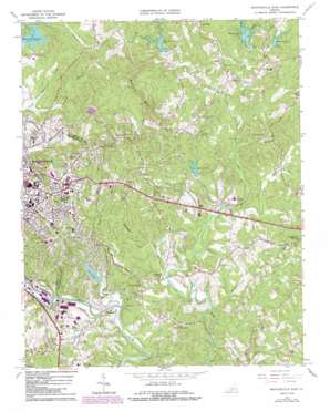
Martinsville East Topo Map Virginia
To zoom in, hover over the map of Martinsville East
USGS Topo Quad 36079f7 - 1:24,000 scale
| Topo Map Name: | Martinsville East |
| USGS Topo Quad ID: | 36079f7 |
| Print Size: | ca. 21 1/4" wide x 27" high |
| Southeast Coordinates: | 36.625° N latitude / 79.75° W longitude |
| Map Center Coordinates: | 36.6875° N latitude / 79.8125° W longitude |
| U.S. State: | VA |
| Filename: | o36079f7.jpg |
| Download Map JPG Image: | Martinsville East topo map 1:24,000 scale |
| Map Type: | Topographic |
| Topo Series: | 7.5´ |
| Map Scale: | 1:24,000 |
| Source of Map Images: | United States Geological Survey (USGS) |
| Alternate Map Versions: |
Martinsville East VA 1964, updated 1966 Download PDF Buy paper map Martinsville East VA 1964, updated 1971 Download PDF Buy paper map Martinsville East VA 1964, updated 1979 Download PDF Buy paper map Martinsville East VA 1964, updated 1984 Download PDF Buy paper map Martinsville East VA 1964, updated 1989 Download PDF Buy paper map Martinsville East VA 2011 Download PDF Buy paper map Martinsville East VA 2013 Download PDF Buy paper map Martinsville East VA 2016 Download PDF Buy paper map |
1:24,000 Topo Quads surrounding Martinsville East
> Back to 36079e1 at 1:100,000 scale
> Back to 36078a1 at 1:250,000 scale
> Back to U.S. Topo Maps home
Martinsville East topo map: Gazetteer
Martinsville East: Airports
Gravely Airport elevation 229m 751′Loury Lester Airpark elevation 315m 1033′
Martinsville-Henry County Memorial Hospital Heliport elevation 309m 1013′
Martinsville East: Dams
Beaver Creek Dam elevation 253m 830′Lake Lanier Dam elevation 208m 682′
Leatherwood Creek Number 2a Dam elevation 241m 790′
Leatherwood Creek Number Four Dam elevation 236m 774′
Leatherwood Creek Number Six Dam elevation 215m 705′
Leatherwood Creek Number Three Dam elevation 234m 767′
Martinsville East: Parks
English Field elevation 322m 1056′Patrick Henry Monument elevation 255m 836′
Martinsville East: Populated Places
Carlisle elevation 234m 767′Chatmoss elevation 200m 656′
Fontaine elevation 229m 751′
Hilltop elevation 295m 967′
Laurel Park elevation 243m 797′
Martinsville elevation 310m 1017′
Old Liberty elevation 248m 813′
Martinsville East: Post Offices
Martinsville Post Office elevation 292m 958′Martinsville East: Reservoirs
Lake Lanier elevation 208m 682′Lake Lanier elevation 208m 682′
Reservoir Number 2 elevation 238m 780′
Reservoir Number 3 elevation 227m 744′
Reservoir Number 4 elevation 233m 764′
Reservoir Number 6 elevation 217m 711′
Martinsville East: Streams
Camp Branch elevation 205m 672′Cobbs Creek elevation 192m 629′
Hairston Branch elevation 229m 751′
Machine Branch elevation 200m 656′
Mill Creek elevation 213m 698′
Mulberry Creek elevation 194m 636′
North Fork Jones Creek elevation 233m 764′
Patterson Branch elevation 206m 675′
Peters Branch elevation 227m 744′
Tanyard Branch elevation 194m 636′
West Fork Leatherwood Creek elevation 206m 675′
Wet Branch elevation 222m 728′
Martinsville East: Summits
Nance Mountain elevation 401m 1315′Martinsville East digital topo map on disk
Buy this Martinsville East topo map showing relief, roads, GPS coordinates and other geographical features, as a high-resolution digital map file on DVD:
Western Virginia & Southern West Virginia
Buy digital topo maps: Western Virginia & Southern West Virginia


