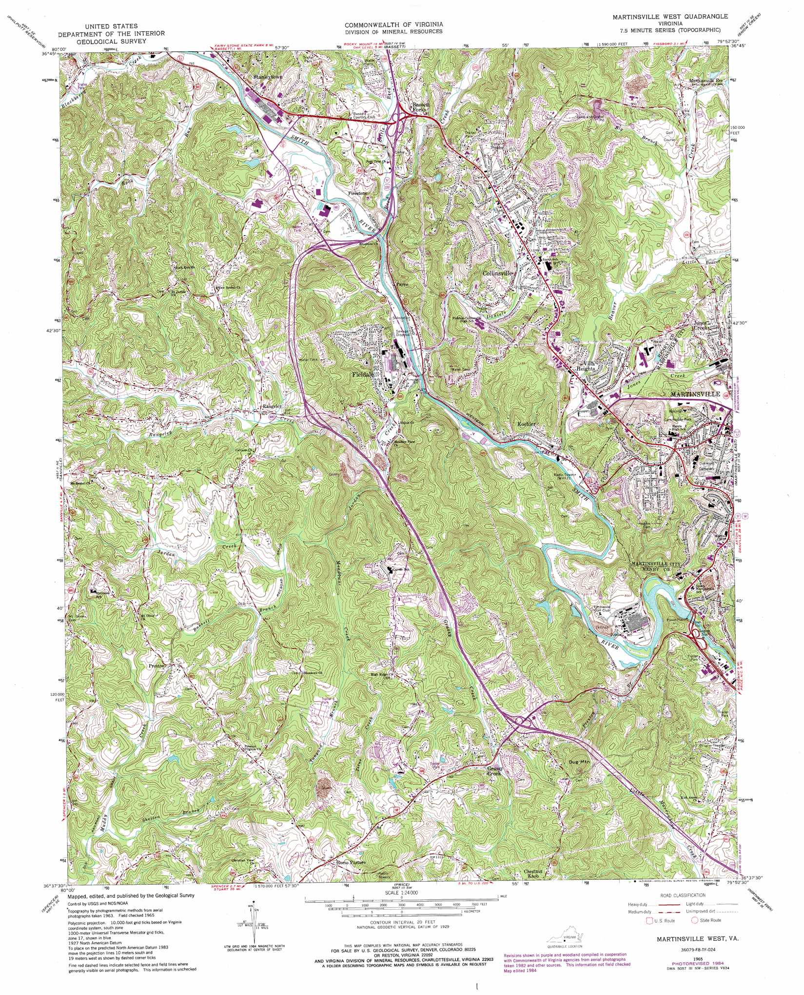
Martinsville West Topo Map Virginia
To zoom in, hover over the map of Martinsville West
USGS Topo Quad 36079f8 - 1:24,000 scale
| Topo Map Name: | Martinsville West |
| USGS Topo Quad ID: | 36079f8 |
| Print Size: | ca. 21 1/4" wide x 27" high |
| Southeast Coordinates: | 36.625° N latitude / 79.875° W longitude |
| Map Center Coordinates: | 36.6875° N latitude / 79.9375° W longitude |
| U.S. State: | VA |
| Filename: | o36079f8.jpg |
| Download Map JPG Image: | Martinsville West topo map 1:24,000 scale |
| Map Type: | Topographic |
| Topo Series: | 7.5´ |
| Map Scale: | 1:24,000 |
| Source of Map Images: | United States Geological Survey (USGS) |
| Alternate Map Versions: |
Martinsville West VA 1965, updated 1966 Download PDF Buy paper map Martinsville West VA 1965, updated 1971 Download PDF Buy paper map Martinsville West VA 1965, updated 1978 Download PDF Buy paper map Martinsville West VA 1965, updated 1984 Download PDF Buy paper map Martinsville West VA 1965, updated 1989 Download PDF Buy paper map Martinsville West VA 2011 Download PDF Buy paper map Martinsville West VA 2013 Download PDF Buy paper map Martinsville West VA 2016 Download PDF Buy paper map |
1:24,000 Topo Quads surrounding Martinsville West
Endicott |
Ferrum |
Rocky Mount |
Gladehill |
Penhook |
Charity |
Philpott Reservoir |
Bassett |
Snow Creek |
Mountain Valley |
Patrick Springs |
Sanville |
Martinsville West |
Martinsville East |
Axton |
Nettleridge |
Spencer |
Price |
Northwest Eden |
Northeast Eden |
Danbury |
Ayersville |
Mayodan |
Southwest Eden |
Southeast Eden |
> Back to 36079e1 at 1:100,000 scale
> Back to 36078a1 at 1:250,000 scale
> Back to U.S. Topo Maps home
Martinsville West topo map: Gazetteer
Martinsville West: Dams
Smith River Dam elevation 210m 688′Martinsville West: Populated Places
Bassett Forks elevation 243m 797′Collinsville elevation 250m 820′
Fieldale elevation 246m 807′
Grassy Creek elevation 289m 948′
Heusley elevation 225m 738′
Horse Pasture elevation 335m 1099′
Jones Creek elevation 237m 777′
Koehler elevation 223m 731′
Payne elevation 237m 777′
Preston elevation 286m 938′
Rangeley elevation 255m 836′
Rock Run elevation 286m 938′
Stanleytown elevation 235m 770′
Villa Heights elevation 219m 718′
Martinsville West: Post Offices
South End Post Office elevation 299m 980′Martinsville West: Reservoirs
Martinsville Reservoir elevation 251m 823′Martinsville West: Streams
Bassett Branch elevation 248m 813′Beaver Creek elevation 217m 711′
Big Branch elevation 229m 751′
Daniels Creek elevation 222m 728′
Grassy Creek elevation 213m 698′
Jones Creek elevation 218m 715′
Jordan Creek elevation 219m 718′
Little Beaver Creek elevation 222m 728′
Little Reed Creek elevation 219m 718′
Meadows Creek elevation 243m 797′
Preston Branch elevation 211m 692′
Rangeley Creek elevation 223m 731′
Reed Creek elevation 220m 721′
Rock Run elevation 221m 725′
Shelton Branch elevation 252m 826′
Tanyard Branch elevation 252m 826′
Titus Creek elevation 252m 826′
Martinsville West: Summits
Dug Mountain elevation 366m 1200′Martinsville West digital topo map on disk
Buy this Martinsville West topo map showing relief, roads, GPS coordinates and other geographical features, as a high-resolution digital map file on DVD:
Western Virginia & Southern West Virginia
Buy digital topo maps: Western Virginia & Southern West Virginia