Winston-Salem West Topo Map North Carolina
To zoom in, hover over the map of Winston-Salem West
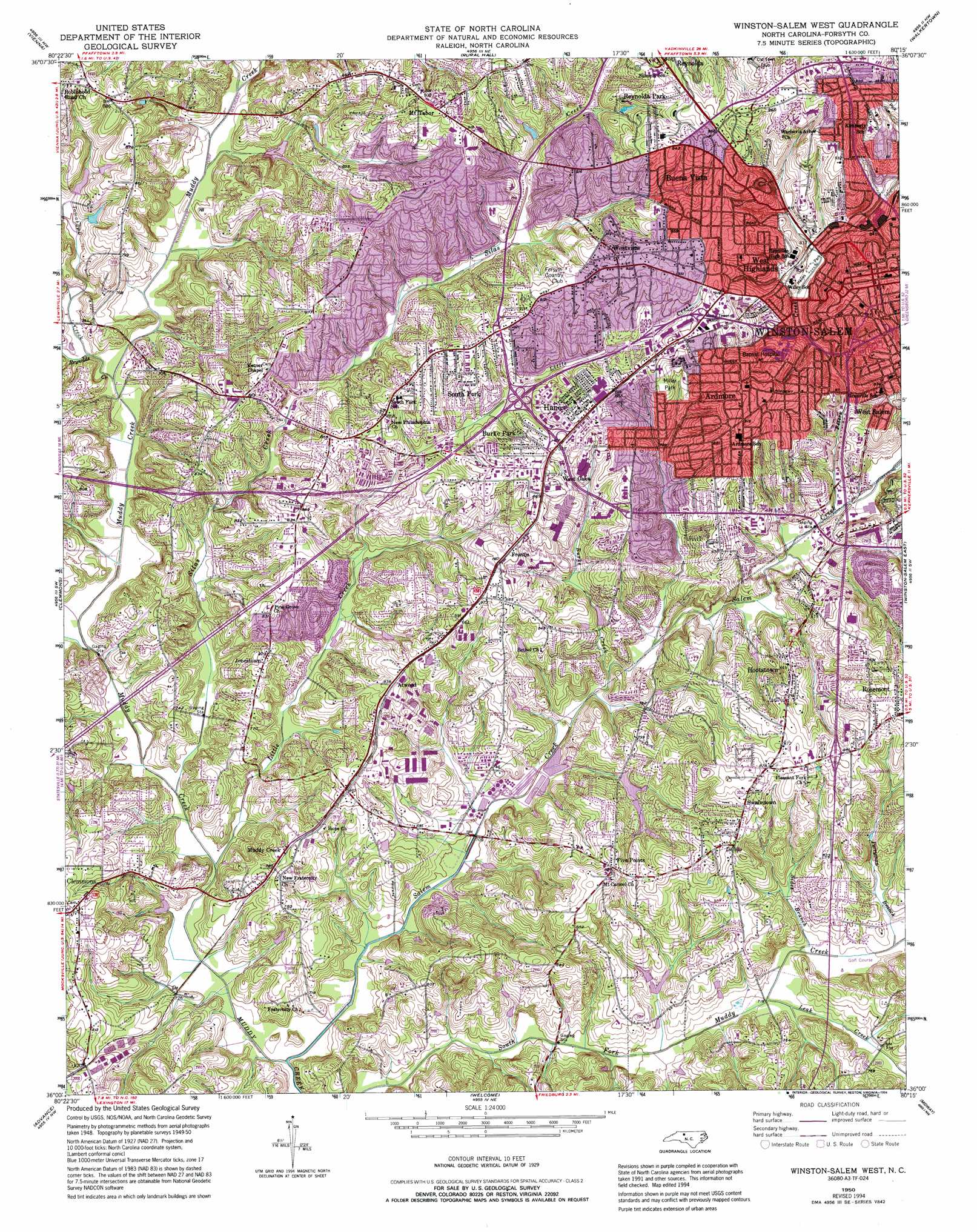
USGS Topo Quad 36080a3 - 1:24,000 scale
| Topo Map Name: | Winston-Salem West |
| USGS Topo Quad ID: | 36080a3 |
| Print Size: | ca. 21 1/4" wide x 27" high |
| Southeast Coordinates: | 36° N latitude / 80.25° W longitude |
| Map Center Coordinates: | 36.0625° N latitude / 80.3125° W longitude |
| U.S. State: | NC |
| Filename: | o36080a3.jpg |
| Download Map JPG Image: | Winston-Salem West topo map 1:24,000 scale |
| Map Type: | Topographic |
| Topo Series: | 7.5´ |
| Map Scale: | 1:24,000 |
| Source of Map Images: | United States Geological Survey (USGS) |
| Alternate Map Versions: |
Winston-Salem West NC 1950, updated 1965 Download PDF Buy paper map Winston-Salem West NC 1950, updated 1973 Download PDF Buy paper map Winston-Salem West NC 1950, updated 1987 Download PDF Buy paper map Winston-Salem West NC 1950, updated 1994 Download PDF Buy paper map Winston-Salem West NC 1951 Download PDF Buy paper map Winston-Salem West NC 1977, updated 1979 Download PDF Buy paper map Winston-Salem West NC 1997, updated 2001 Download PDF Buy paper map Winston-Salem West NC 2010 Download PDF Buy paper map Winston-Salem West NC 2013 Download PDF Buy paper map Winston-Salem West NC 2016 Download PDF Buy paper map |
1:24,000 Topo Quads surrounding Winston-Salem West
Siloam |
Pinnacle |
King |
Walnut Cove |
Belews Lake |
East Bend |
Vienna |
Rural Hall |
Walkertown |
Belews Creek |
Farmington |
Clemmons |
Winston-Salem West |
Winston-Salem East |
Kernersville |
Mocksville |
Advance |
Welcome |
Midway |
High Point West |
Cooleemee |
Churchland |
Lexington West |
Lexington East |
Fair Grove |
> Back to 36080a1 at 1:100,000 scale
> Back to 36080a1 at 1:250,000 scale
> Back to U.S. Topo Maps home
Winston-Salem West topo map: Gazetteer
Winston-Salem West: Dams
Beauchamp Lake Dam elevation 230m 754′Cooper Lake Dam elevation 233m 764′
Lower Janita Lake Dam elevation 226m 741′
Myers Lake Dam elevation 229m 751′
Winston-Salem West: Parks
Bolton Park elevation 251m 823′Hanes Park elevation 238m 780′
Hobby Park elevation 228m 748′
Kimberly Park elevation 284m 931′
Miller Park elevation 261m 856′
Parkland Park elevation 271m 889′
Winston-Salem West: Populated Places
Ardmore elevation 274m 898′Atwood elevation 255m 836′
Atwood Acres elevation 242m 793′
Briarcliff Manor elevation 243m 797′
Brook Hollow elevation 244m 800′
Buena Vista elevation 280m 918′
Burke Park elevation 258m 846′
Echo Bluff Trailer Park elevation 229m 751′
Five Points elevation 261m 856′
Fox Hall elevation 267m 875′
Frontis elevation 255m 836′
Hanes elevation 274m 898′
Hootstown elevation 254m 833′
Jonestown elevation 249m 816′
Mount Tabor elevation 291m 954′
Muddy Creek elevation 240m 787′
Pine Dale Manor elevation 257m 843′
Reynolda Park elevation 279m 915′
Salem Woods elevation 232m 761′
South Fork elevation 272m 892′
Swaimtown elevation 256m 839′
West Highlands elevation 259m 849′
West Oaks elevation 264m 866′
West Salem elevation 262m 859′
Westview elevation 284m 931′
Williamsburg Square elevation 243m 797′
Wilshire elevation 233m 764′
Winston-Salem West: Reservoirs
Beauchamp Lake elevation 230m 754′Cooper Lake elevation 233m 764′
Lower Janita Lake elevation 226m 741′
Myers Lake elevation 229m 751′
Winston-Salem West: Streams
Burke Creek elevation 214m 702′James Branch elevation 224m 734′
Leak Creek elevation 215m 705′
Little Creek elevation 208m 682′
Mill Creek elevation 225m 738′
Perryman Branch elevation 218m 715′
Peters Creek elevation 221m 725′
Reynolds Creek elevation 220m 721′
Salem Creek elevation 206m 675′
Sides Branch elevation 218m 715′
Silas Creek elevation 209m 685′
Tomahawk Creek elevation 221m 725′
Winston-Salem West digital topo map on disk
Buy this Winston-Salem West topo map showing relief, roads, GPS coordinates and other geographical features, as a high-resolution digital map file on DVD:
Western Virginia & Southern West Virginia
Buy digital topo maps: Western Virginia & Southern West Virginia