Lone Hickory Topo Map North Carolina
To zoom in, hover over the map of Lone Hickory
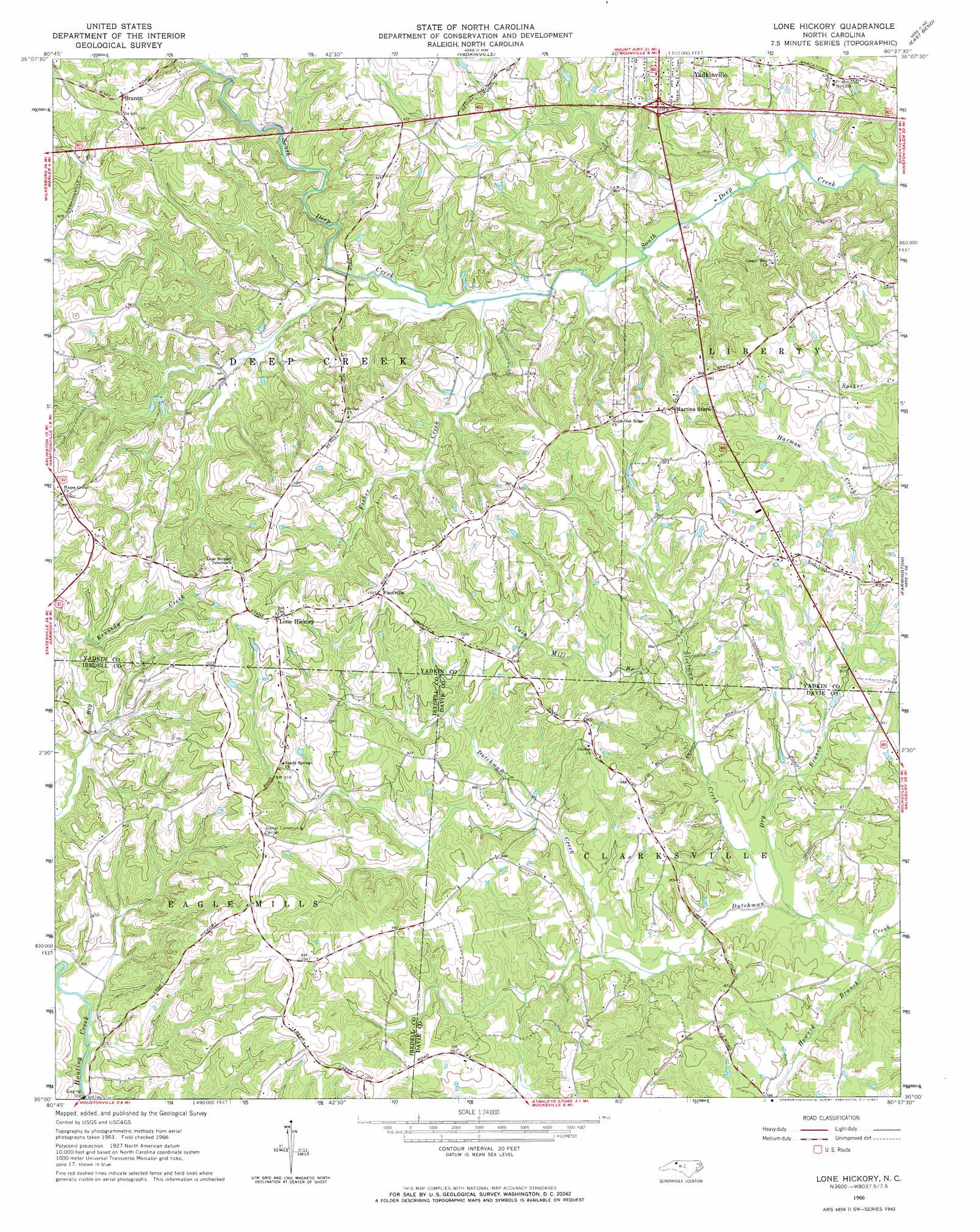
USGS Topo Quad 36080a6 - 1:24,000 scale
| Topo Map Name: | Lone Hickory |
| USGS Topo Quad ID: | 36080a6 |
| Print Size: | ca. 21 1/4" wide x 27" high |
| Southeast Coordinates: | 36° N latitude / 80.625° W longitude |
| Map Center Coordinates: | 36.0625° N latitude / 80.6875° W longitude |
| U.S. State: | NC |
| Filename: | o36080a6.jpg |
| Download Map JPG Image: | Lone Hickory topo map 1:24,000 scale |
| Map Type: | Topographic |
| Topo Series: | 7.5´ |
| Map Scale: | 1:24,000 |
| Source of Map Images: | United States Geological Survey (USGS) |
| Alternate Map Versions: |
Lone Hickory NC 1966, updated 1967 Download PDF Buy paper map Lone Hickory NC 2010 Download PDF Buy paper map Lone Hickory NC 2013 Download PDF Buy paper map Lone Hickory NC 2016 Download PDF Buy paper map |
1:24,000 Topo Quads surrounding Lone Hickory
Thurmond |
Elkin North |
Copeland |
Siloam |
Pinnacle |
Ronda |
Elkin South |
Yadkinville |
East Bend |
Vienna |
Osbornville |
Brooks Crossroads |
Lone Hickory |
Farmington |
Clemmons |
Central |
Harmony |
Calahaln |
Mocksville |
Advance |
Statesville West |
Statesville East |
Cool Springs |
Cooleemee |
Churchland |
> Back to 36080a1 at 1:100,000 scale
> Back to 36080a1 at 1:250,000 scale
> Back to U.S. Topo Maps home
Lone Hickory topo map: Gazetteer
Lone Hickory: Dams
Dutchman Creek W/S Structure Number Five Dam elevation 228m 748′Dutchman Creek W/S Structure Number Two Dam elevation 239m 784′
James Dobbins Lake Dam elevation 263m 862′
Leslie Chamberlain Lake Dam elevation 241m 790′
Thad Carlton Lake Dam elevation 262m 859′
Todd Pond Dam elevation 263m 862′
William Arnold Lake Dam elevation 249m 816′
Yadkin Recreation Park Lake Dam elevation 249m 816′
Lone Hickory: Populated Places
Branon elevation 297m 974′Footville elevation 316m 1036′
Lone Hickory elevation 321m 1053′
Lone Hickory: Post Offices
Clarksville Post Office elevation 271m 889′Felix Post Office elevation 246m 807′
Lone Hickory: Reservoirs
Dutchman Creek W/S Number Five elevation 228m 748′Dutchman Creek W/S Number Two elevation 239m 784′
James Dobbins Lake elevation 263m 862′
Leslie Chamberlain Lake elevation 241m 790′
Thad Carlton Lake elevation 262m 859′
Todd Pond elevation 263m 862′
William Arnold Lake elevation 249m 816′
Yadkin Recreation Park Lake elevation 249m 816′
Lone Hickory: Streams
Big Kennedy Creek elevation 229m 751′Cain Mill Branch elevation 239m 784′
Dry Branch elevation 222m 728′
Fisher Creek elevation 233m 764′
Howard Branch elevation 237m 777′
Kennedy Creek elevation 226m 741′
Steelman Creek elevation 224m 734′
Lone Hickory digital topo map on disk
Buy this Lone Hickory topo map showing relief, roads, GPS coordinates and other geographical features, as a high-resolution digital map file on DVD:
Western Virginia & Southern West Virginia
Buy digital topo maps: Western Virginia & Southern West Virginia