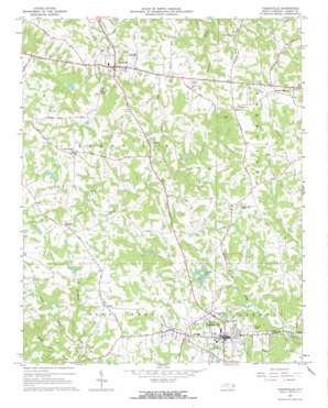
Yadkinville Topo Map North Carolina
To zoom in, hover over the map of Yadkinville
USGS Topo Quad 36080b6 - 1:24,000 scale
| Topo Map Name: | Yadkinville |
| USGS Topo Quad ID: | 36080b6 |
| Print Size: | ca. 21 1/4" wide x 27" high |
| Southeast Coordinates: | 36.125° N latitude / 80.625° W longitude |
| Map Center Coordinates: | 36.1875° N latitude / 80.6875° W longitude |
| U.S. State: | NC |
| Filename: | o36080b6.jpg |
| Download Map JPG Image: | Yadkinville topo map 1:24,000 scale |
| Map Type: | Topographic |
| Topo Series: | 7.5´ |
| Map Scale: | 1:24,000 |
| Source of Map Images: | United States Geological Survey (USGS) |
| Alternate Map Versions: |
Yadkinville NC 1966, updated 1967 Download PDF Buy paper map Yadkinville NC 2010 Download PDF Buy paper map Yadkinville NC 2013 Download PDF Buy paper map Yadkinville NC 2016 Download PDF Buy paper map |
1:24,000 Topo Quads surrounding Yadkinville
> Back to 36080a1 at 1:100,000 scale
> Back to 36080a1 at 1:250,000 scale
> Back to U.S. Topo Maps home
Yadkinville topo map: Gazetteer
Yadkinville: Airports
Boonville Airport elevation 276m 905′Yadkinville: Dams
Arnie Shore Lake Dam elevation 268m 879′Fax Brown Lake Dam elevation 300m 984′
Frank Poindexter Dam elevation 284m 931′
George Penergrass Lake Dam elevation 273m 895′
Gray Casstevens Lake Dam elevation 299m 980′
Howard Lake Dam elevation 312m 1023′
Jim Frazier Lake Dam elevation 291m 954′
O J Fleming Lake Dam elevation 286m 938′
Shermer Pond Dam elevation 259m 849′
Twiman Candle Lake Dam elevation 278m 912′
William Shugart Lake Dam elevation 276m 905′
Yadkinville: Lakes
Dobbins Pond elevation 259m 849′Yadkinville: Populated Places
Boonville elevation 325m 1066′Center elevation 315m 1033′
Mount Pleasant elevation 317m 1040′
Nebo elevation 326m 1069′
Yadkinville elevation 293m 961′
Yadkinville: Reservoirs
Arnie Shore Lake elevation 268m 879′Deep Creek W/S Number Sixteen elevation 284m 931′
Fax Brown Lake elevation 300m 984′
George Penergrass Lake elevation 273m 895′
Gray Casstevens Lake elevation 299m 980′
Howard Lake elevation 312m 1023′
Jim Frazier Lake elevation 291m 954′
O J Fleming Lake elevation 286m 938′
Shermer Pond elevation 259m 849′
Twiman Candle Lake elevation 278m 912′
William Shugart Lake elevation 276m 905′
Yadkinville: Streams
Cranberry Creek elevation 253m 830′Farmers Creek elevation 253m 830′
Piney Branch elevation 264m 866′
Town Branch elevation 248m 813′
Yadkinville digital topo map on disk
Buy this Yadkinville topo map showing relief, roads, GPS coordinates and other geographical features, as a high-resolution digital map file on DVD:
Western Virginia & Southern West Virginia
Buy digital topo maps: Western Virginia & Southern West Virginia


