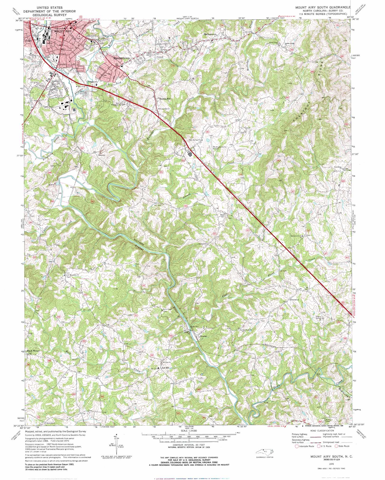
Mount Airy South Topo Map North Carolina
To zoom in, hover over the map of Mount Airy South
USGS Topo Quad 36080d5 - 1:24,000 scale
| Topo Map Name: | Mount Airy South |
| USGS Topo Quad ID: | 36080d5 |
| Print Size: | ca. 21 1/4" wide x 27" high |
| Southeast Coordinates: | 36.375° N latitude / 80.5° W longitude |
| Map Center Coordinates: | 36.4375° N latitude / 80.5625° W longitude |
| U.S. State: | NC |
| Filename: | o36080d5.jpg |
| Download Map JPG Image: | Mount Airy South topo map 1:24,000 scale |
| Map Type: | Topographic |
| Topo Series: | 7.5´ |
| Map Scale: | 1:24,000 |
| Source of Map Images: | United States Geological Survey (USGS) |
| Alternate Map Versions: |
Mount Airy South NC 1970, updated 1973 Download PDF Buy paper map Mount Airy South NC 1970, updated 1988 Download PDF Buy paper map Mount Airy South NC 1976, updated 1979 Download PDF Buy paper map Mount Airy South NC 1996, updated 2000 Download PDF Buy paper map Mount Airy South NC 2010 Download PDF Buy paper map Mount Airy South NC 2014 Download PDF Buy paper map Mount Airy South NC 2016 Download PDF Buy paper map |
1:24,000 Topo Quads surrounding Mount Airy South
Woodlawn |
Fancy Gap |
Laurel Fork |
Meadows Of Dan |
Stuart |
Lambsburg |
Cana |
Mount Airy North |
Claudville |
Stuart Se |
Bottom |
Dobson |
Mount Airy South |
Pilot Mountain |
Hanging Rock |
Elkin North |
Copeland |
Siloam |
Pinnacle |
King |
Elkin South |
Yadkinville |
East Bend |
Vienna |
Rural Hall |
> Back to 36080a1 at 1:100,000 scale
> Back to 36080a1 at 1:250,000 scale
> Back to U.S. Topo Maps home
Mount Airy South topo map: Gazetteer
Mount Airy South: Airports
Mount Airy-Surry County Airport elevation 363m 1190′Mount Airy South: Parks
Mount Airy Historic District elevation 335m 1099′Old Cadel Ford elevation 287m 941′
Mount Airy South: Populated Places
Ararat elevation 275m 902′Ash Hill elevation 334m 1095′
Bannertown elevation 321m 1053′
Black Water elevation 395m 1295′
Boones Hill elevation 364m 1194′
Flat Shoals (historical) elevation 282m 925′
Indian Grove elevation 429m 1407′
Long Hill elevation 350m 1148′
Mount Airy elevation 335m 1099′
Oak Grove elevation 331m 1085′
Sheltontown elevation 375m 1230′
Mount Airy South: Post Offices
Ash Hill Post Office (historical) elevation 335m 1099′Indian Grove Post Office (historical) elevation 443m 1453′
Mount Airy South: Streams
Caddle Creek elevation 282m 925′Faulkner Creek elevation 303m 994′
Flat Shoal Creek elevation 269m 882′
Heatherly Creek elevation 276m 905′
Lovills Creek elevation 295m 967′
Oldfield Creek elevation 273m 895′
Rutledge Creek elevation 291m 954′
Seed Cane Creek elevation 298m 977′
Stewarts Creek elevation 293m 961′
Stoney Creek elevation 275m 902′
Whittier Creek elevation 282m 925′
Mount Airy South digital topo map on disk
Buy this Mount Airy South topo map showing relief, roads, GPS coordinates and other geographical features, as a high-resolution digital map file on DVD:
Western Virginia & Southern West Virginia
Buy digital topo maps: Western Virginia & Southern West Virginia