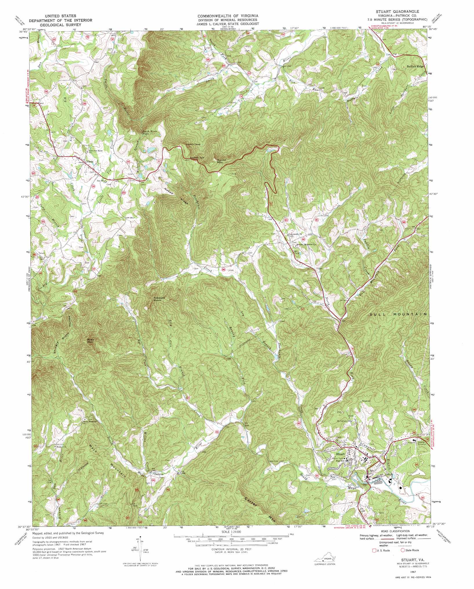
Stuart Topo Map Virginia
To zoom in, hover over the map of Stuart
USGS Topo Quad 36080f3 - 1:24,000 scale
| Topo Map Name: | Stuart |
| USGS Topo Quad ID: | 36080f3 |
| Print Size: | ca. 21 1/4" wide x 27" high |
| Southeast Coordinates: | 36.625° N latitude / 80.25° W longitude |
| Map Center Coordinates: | 36.6875° N latitude / 80.3125° W longitude |
| U.S. State: | VA |
| Filename: | o36080f3.jpg |
| Download Map JPG Image: | Stuart topo map 1:24,000 scale |
| Map Type: | Topographic |
| Topo Series: | 7.5´ |
| Map Scale: | 1:24,000 |
| Source of Map Images: | United States Geological Survey (USGS) |
| Alternate Map Versions: |
Stuart VA 1967, updated 1971 Download PDF Buy paper map Stuart VA 1967, updated 1971 Download PDF Buy paper map Stuart VA 2010 Download PDF Buy paper map Stuart VA 2013 Download PDF Buy paper map Stuart VA 2016 Download PDF Buy paper map |
1:24,000 Topo Quads surrounding Stuart
Indian Valley |
Alum Ridge |
Floyd |
Endicott |
Ferrum |
Dugspur |
Willis |
Woolwine |
Charity |
Philpott Reservoir |
Laurel Fork |
Meadows Of Dan |
Stuart |
Patrick Springs |
Sanville |
Mount Airy North |
Claudville |
Stuart Se |
Nettleridge |
Spencer |
Mount Airy South |
Pilot Mountain |
Hanging Rock |
Danbury |
Ayersville |
> Back to 36080e1 at 1:100,000 scale
> Back to 36080a1 at 1:250,000 scale
> Back to U.S. Topo Maps home
Stuart topo map: Gazetteer
Stuart: Dams
Mitchells Dam elevation 870m 2854′Williams Dam elevation 449m 1473′
Stuart: Falls
Smith River Falls elevation 799m 2621′Stuart: Gaps
Lovers Leap elevation 872m 2860′Stuart: Populated Places
Cruzes Store elevation 422m 1384′Dobyns elevation 451m 1479′
Stuart elevation 410m 1345′
Vesta elevation 866m 2841′
Stuart: Ridges
Naked Ridge elevation 813m 2667′Stuart: Streams
Big Ivy Creek elevation 826m 2709′Brushy Fork elevation 408m 1338′
Bull Mountain Fork elevation 427m 1400′
Camp Branch elevation 818m 2683′
Campbell Branch elevation 359m 1177′
Ivy Branch elevation 420m 1377′
Lily Cove Branch elevation 453m 1486′
Little Ivy Creek elevation 826m 2709′
North Fork Poor House Creek elevation 378m 1240′
North Fork Smith River elevation 460m 1509′
Poorhouse Creek elevation 371m 1217′
Puddin Creek elevation 443m 1453′
Rich Run elevation 426m 1397′
Rye Cove Creek elevation 418m 1371′
Waterfall Branch elevation 634m 2080′
Wilson Creek elevation 451m 1479′
Stuart: Summits
Carter Mountain elevation 709m 2326′Grassy Knob elevation 745m 2444′
Indian Grave Mountain elevation 683m 2240′
Mayo Mountain elevation 622m 2040′
Rock Mountain elevation 883m 2896′
Spoon Mountain elevation 936m 3070′
Tobacco Knob elevation 766m 2513′
Toms Knob elevation 572m 1876′
Stuart: Valleys
Shingle Block Hollow elevation 584m 1916′Stuart digital topo map on disk
Buy this Stuart topo map showing relief, roads, GPS coordinates and other geographical features, as a high-resolution digital map file on DVD:
Western Virginia & Southern West Virginia
Buy digital topo maps: Western Virginia & Southern West Virginia