Laurel Fork Topo Map Virginia
To zoom in, hover over the map of Laurel Fork
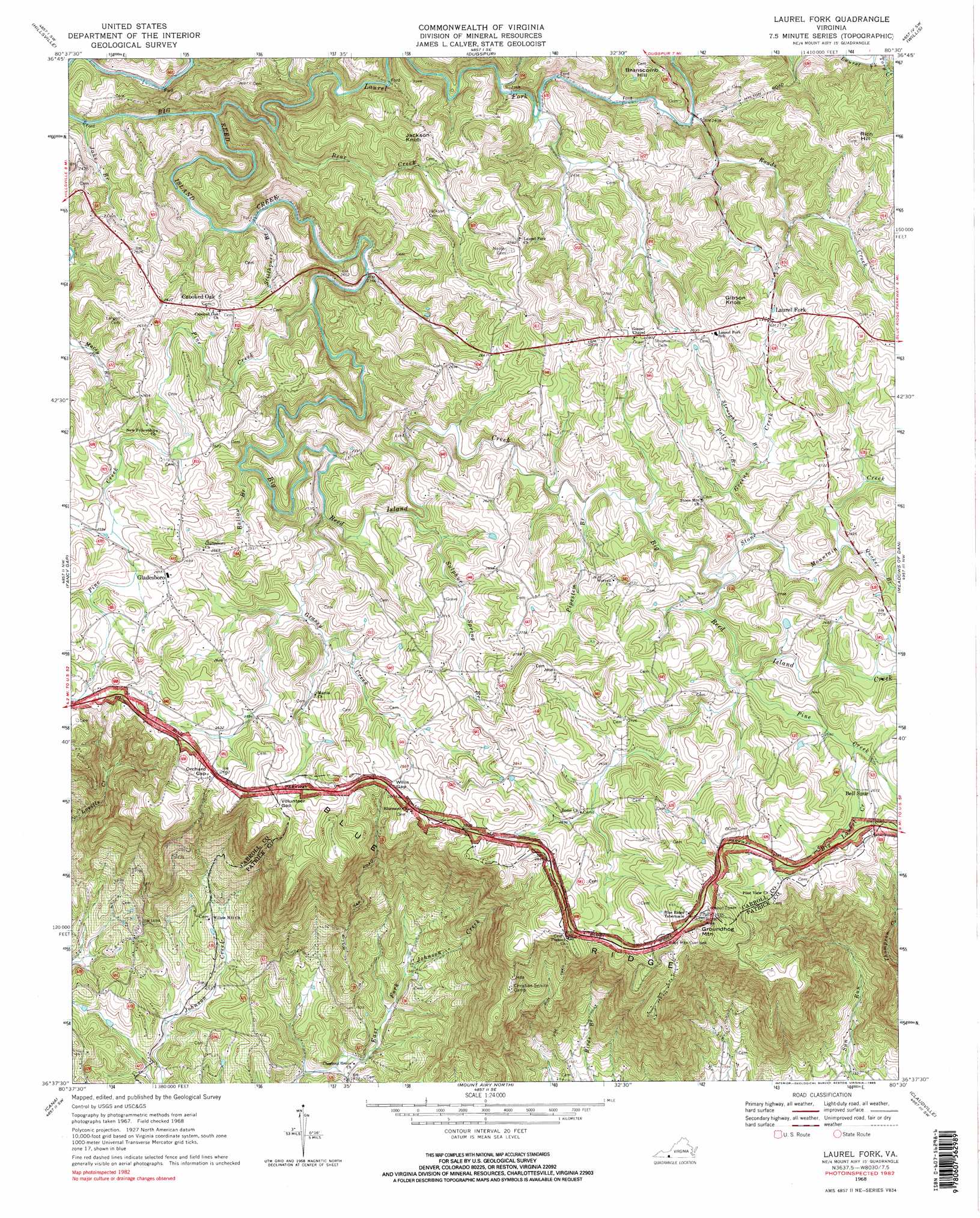
USGS Topo Quad 36080f5 - 1:24,000 scale
| Topo Map Name: | Laurel Fork |
| USGS Topo Quad ID: | 36080f5 |
| Print Size: | ca. 21 1/4" wide x 27" high |
| Southeast Coordinates: | 36.625° N latitude / 80.5° W longitude |
| Map Center Coordinates: | 36.6875° N latitude / 80.5625° W longitude |
| U.S. State: | VA |
| Filename: | o36080f5.jpg |
| Download Map JPG Image: | Laurel Fork topo map 1:24,000 scale |
| Map Type: | Topographic |
| Topo Series: | 7.5´ |
| Map Scale: | 1:24,000 |
| Source of Map Images: | United States Geological Survey (USGS) |
| Alternate Map Versions: |
Laurel Fork VA 1968, updated 1971 Download PDF Buy paper map Laurel Fork VA 1968, updated 1985 Download PDF Buy paper map Laurel Fork VA 1968, updated 1985 Download PDF Buy paper map Laurel Fork VA 2010 Download PDF Buy paper map Laurel Fork VA 2013 Download PDF Buy paper map Laurel Fork VA 2016 Download PDF Buy paper map |
1:24,000 Topo Quads surrounding Laurel Fork
Fosters Falls |
Hiwassee |
Indian Valley |
Alum Ridge |
Floyd |
Sylvatus |
Hillsville |
Dugspur |
Willis |
Woolwine |
Woodlawn |
Fancy Gap |
Laurel Fork |
Meadows Of Dan |
Stuart |
Lambsburg |
Cana |
Mount Airy North |
Claudville |
Stuart Se |
Bottom |
Dobson |
Mount Airy South |
Pilot Mountain |
Hanging Rock |
> Back to 36080e1 at 1:100,000 scale
> Back to 36080a1 at 1:250,000 scale
> Back to U.S. Topo Maps home
Laurel Fork topo map: Gazetteer
Laurel Fork: Dams
Olde Mill Golf Club Dam elevation 772m 2532′Laurel Fork: Gaps
Orchard Gap elevation 813m 2667′Volunteer Gap elevation 830m 2723′
Willis Gap elevation 816m 2677′
Laurel Fork: Populated Places
Crooked Oak elevation 802m 2631′Gladesboro elevation 805m 2641′
Laurel Fork elevation 843m 2765′
Nester elevation 762m 2500′
Laurel Fork: Streams
Bear Creek elevation 694m 2276′Bellow Branch elevation 738m 2421′
Big Laurel Creek elevation 791m 2595′
Grassy Creek elevation 742m 2434′
Greens Creek elevation 773m 2536′
Jake Branch elevation 676m 2217′
Laurel Fork elevation 682m 2237′
Pine Creek elevation 717m 2352′
Pine Creek elevation 773m 2536′
Pipestem Branch elevation 762m 2500′
Potters Branch elevation 785m 2575′
Quaker Branch elevation 791m 2595′
Roads Creek elevation 731m 2398′
Stillhouse Branch elevation 708m 2322′
Stone Mountain Creek elevation 766m 2513′
Straight Branch elevation 791m 2595′
Sulphur Spring Branch elevation 754m 2473′
Laurel Fork: Summits
Branscomb Hill elevation 820m 2690′Gibson Knob elevation 921m 3021′
Groundhog Mountain elevation 924m 3031′
Jackson Knob elevation 865m 2837′
Rich Hill elevation 919m 3015′
Laurel Fork: Trails
Run Trail elevation 704m 2309′Laurel Fork digital topo map on disk
Buy this Laurel Fork topo map showing relief, roads, GPS coordinates and other geographical features, as a high-resolution digital map file on DVD:
Western Virginia & Southern West Virginia
Buy digital topo maps: Western Virginia & Southern West Virginia