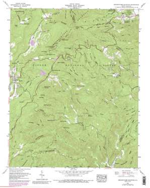
Grandfather Mountain Topo Map North Carolina
To zoom in, hover over the map of Grandfather Mountain
USGS Topo Quad 36081a7 - 1:24,000 scale
| Topo Map Name: | Grandfather Mountain |
| USGS Topo Quad ID: | 36081a7 |
| Print Size: | ca. 21 1/4" wide x 27" high |
| Southeast Coordinates: | 36° N latitude / 81.75° W longitude |
| Map Center Coordinates: | 36.0625° N latitude / 81.8125° W longitude |
| U.S. State: | NC |
| Filename: | o36081a7.jpg |
| Download Map JPG Image: | Grandfather Mountain topo map 1:24,000 scale |
| Map Type: | Topographic |
| Topo Series: | 7.5´ |
| Map Scale: | 1:24,000 |
| Source of Map Images: | United States Geological Survey (USGS) |
| Alternate Map Versions: |
Grandfather Mountain NC 1960, updated 1961 Download PDF Buy paper map Grandfather Mountain NC 1960, updated 1966 Download PDF Buy paper map Grandfather Mountain NC 1960, updated 1978 Download PDF Buy paper map Grandfather Mountain NC 1960, updated 1988 Download PDF Buy paper map Grandfather Mountain NC 1960, updated 1988 Download PDF Buy paper map Grandfather Mountain NC 1994, updated 1998 Download PDF Buy paper map Grandfather Mountain NC 2011 Download PDF Buy paper map Grandfather Mountain NC 2013 Download PDF Buy paper map Grandfather Mountain NC 2016 Download PDF Buy paper map |
| FStopo: | US Forest Service topo Grandfather Mountain is available: Download FStopo PDF Download FStopo TIF |
1:24,000 Topo Quads surrounding Grandfather Mountain
> Back to 36081a1 at 1:100,000 scale
> Back to 36080a1 at 1:250,000 scale
> Back to U.S. Topo Maps home
Grandfather Mountain topo map: Gazetteer
Grandfather Mountain: Bridges
Mile High Swinging Bridge elevation 1595m 5232′Grandfather Mountain: Cliffs
Big Lost Cove Cliffs elevation 907m 2975′Flattop Cliffs elevation 1520m 4986′
Linville Bluffs elevation 1374m 4507′
Little Lost Cove Cliffs elevation 961m 3152′
Rattlesnake Cliffs elevation 1036m 3398′
Grandfather Mountain: Dams
Grandfather Mountain Lake Lake Dam elevation 1192m 3910′Grandmother Dam elevation 1155m 3789′
Inver Lochy Dam elevation 1231m 4038′
Grandfather Mountain: Gaps
Deep Gap elevation 1276m 4186′Grandmother Gap elevation 1242m 4074′
Linville Gap elevation 1223m 4012′
Old House Gap elevation 917m 3008′
Grandfather Mountain: Pillars
The Sphinx Rock elevation 1410m 4625′Grandfather Mountain: Populated Places
Cherokee Woods elevation 995m 3264′Edgemont elevation 478m 1568′
Gragg elevation 812m 2664′
Grandfather elevation 1191m 3907′
Hemlock Ridge elevation 1125m 3690′
Linville elevation 1117m 3664′
Roseborough elevation 663m 2175′
Grandfather Mountain: Reservoirs
Coffey Trout Lake elevation 799m 2621′Grandfather Mountain Lake elevation 1192m 3910′
Grandmother Lake elevation 1155m 3789′
Inver Lochy Lake elevation 1231m 4038′
Grandfather Mountain: Ridges
Bark Camp Ridge elevation 724m 2375′Big Lost Cove Ridge elevation 1128m 3700′
Breakneck Ridge elevation 929m 3047′
Gabes Mountain elevation 1041m 3415′
Grandfather Mountain elevation 1797m 5895′
Green Ridge elevation 1301m 4268′
Hughes Ridge elevation 742m 2434′
Long Ridge elevation 834m 2736′
Pilot Ridge elevation 1290m 4232′
Rough Ridge elevation 1207m 3959′
Schoolhouse Ridge elevation 645m 2116′
Timber Ridge elevation 804m 2637′
Yancey Ridge elevation 732m 2401′
Grandfather Mountain: Streams
Andrews Creek elevation 790m 2591′Bee Branch elevation 781m 2562′
Big Grassy Creek elevation 1166m 3825′
Bucks Timber Creek elevation 623m 2043′
Cary Flat Branch elevation 640m 2099′
Chestnut Cove Branch elevation 784m 2572′
Crusher Branch elevation 525m 1722′
Flat Land Branch elevation 624m 2047′
Gragg Prong elevation 520m 1706′
Green Mountain Creek elevation 959m 3146′
Laurel Creek elevation 495m 1624′
Laurel Mountain Branch elevation 556m 1824′
Ling Branch elevation 859m 2818′
Linn Cove Branch elevation 1051m 3448′
Little Grassy Creek elevation 1190m 3904′
Little Laurel Creek elevation 615m 2017′
Little Lost Cove Creek elevation 606m 1988′
Little Wilson Creek elevation 798m 2618′
Lost Cove Creek elevation 474m 1555′
Major Branch elevation 891m 2923′
North Harper Creek elevation 607m 1991′
Poplar Spring Branch elevation 631m 2070′
Rockhouse Creek elevation 480m 1574′
Sassafras Creek elevation 688m 2257′
Stack Rock Creek elevation 692m 2270′
Turkey Branch elevation 586m 1922′
Webb Creek elevation 659m 2162′
West Fork Linville River elevation 1107m 3631′
Grandfather Mountain: Summits
Beacon Heights elevation 1315m 4314′Bee Mountain elevation 898m 2946′
Big Rough Knob elevation 1232m 4041′
Brier Knob elevation 1245m 4084′
Calloway Peak elevation 1797m 5895′
Flat Rock elevation 1258m 4127′
Flattop Mountain elevation 1507m 4944′
Grandmother Mountain elevation 1403m 4603′
Green Mountain elevation 1331m 4366′
Laurel Mountain elevation 749m 2457′
Little Bald elevation 1303m 4274′
Marks Mountain elevation 879m 2883′
Ned Mountain elevation 863m 2831′
Pilot Knob elevation 1445m 4740′
Raven Rocks elevation 1735m 5692′
Sassafras Knob elevation 933m 3061′
Grandfather Mountain: Trails
Daniel Boone Scout Trail elevation 1677m 5501′Yancey Ridge Trail elevation 706m 2316′
Grandfather Mountain digital topo map on disk
Buy this Grandfather Mountain topo map showing relief, roads, GPS coordinates and other geographical features, as a high-resolution digital map file on DVD:
Western Virginia & Southern West Virginia
Buy digital topo maps: Western Virginia & Southern West Virginia


