Boone Topo Map North Carolina
To zoom in, hover over the map of Boone
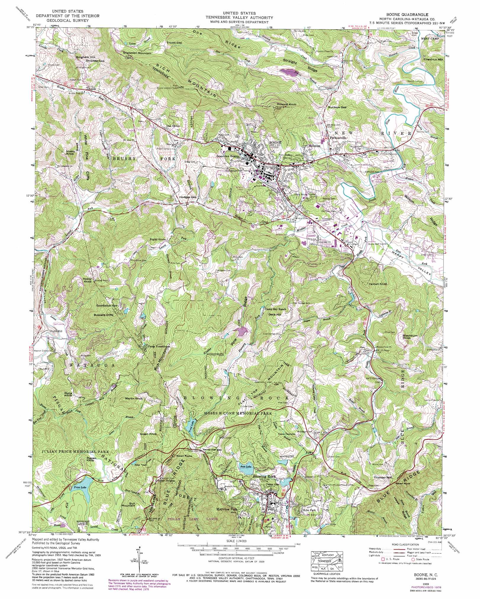
USGS Topo Quad 36081b6 - 1:24,000 scale
| Topo Map Name: | Boone |
| USGS Topo Quad ID: | 36081b6 |
| Print Size: | ca. 21 1/4" wide x 27" high |
| Southeast Coordinates: | 36.125° N latitude / 81.625° W longitude |
| Map Center Coordinates: | 36.1875° N latitude / 81.6875° W longitude |
| U.S. State: | NC |
| Filename: | o36081b6.jpg |
| Download Map JPG Image: | Boone topo map 1:24,000 scale |
| Map Type: | Topographic |
| Topo Series: | 7.5´ |
| Map Scale: | 1:24,000 |
| Source of Map Images: | United States Geological Survey (USGS) |
| Alternate Map Versions: |
Boone NC 1934 Download PDF Buy paper map Boone NC 1959, updated 1962 Download PDF Buy paper map Boone NC 1959, updated 1968 Download PDF Buy paper map Boone NC 1959, updated 1980 Download PDF Buy paper map Boone NC 1959, updated 1989 Download PDF Buy paper map Boone NC 1959, updated 1989 Download PDF Buy paper map Boone NC 1994, updated 1998 Download PDF Buy paper map Boone NC 2011 Download PDF Buy paper map Boone NC 2013 Download PDF Buy paper map Boone NC 2016 Download PDF Buy paper map |
| FStopo: | US Forest Service topo Boone is available: Download FStopo PDF Download FStopo TIF |
1:24,000 Topo Quads surrounding Boone
Doe |
Mountain City |
Baldwin Gap |
Warrensville |
Jefferson |
Elk Mills |
Sherwood |
Zionville |
Todd |
Glendale Springs |
Elk Park |
Valle Crucis |
Boone |
Deep Gap |
Maple Springs |
Newland |
Grandfather Mountain |
Globe |
Buffalo Cove |
Grandin |
Linville Falls |
Chestnut Mountain |
Collettsville |
Lenoir |
Kings Creek |
> Back to 36081a1 at 1:100,000 scale
> Back to 36080a1 at 1:250,000 scale
> Back to U.S. Topo Maps home
Boone topo map: Gazetteer
Boone: Airports
Boone-Blowing Rock Airport elevation 1006m 3300′Boone: Cliffs
White Pine Cliffs elevation 986m 3234′Boone: Dams
A S U Dam elevation 1050m 3444′Appalachian Ski Mountain Dam elevation 1105m 3625′
Boone Water Supply Dam elevation 1143m 3750′
Chetola Lake Dam elevation 1053m 3454′
Cone Lake Dam elevation 1086m 3562′
Heart Lake Dam elevation 1109m 3638′
Julian Price Lake Dam elevation 1031m 3382′
Old Blowing Rock Water Supply Dam elevation 1063m 3487′
Sims Pond elevation 1039m 3408′
Trout Lake Dam elevation 1144m 3753′
Boone: Gaps
Buckeye Gap elevation 1020m 3346′Hodges Gap elevation 1010m 3313′
Sandy Flat Gap elevation 1169m 3835′
Straddle Gap elevation 1024m 3359′
Trivett Gap elevation 1315m 4314′
Boone: Lakes
Sims Pond elevation 1046m 3431′Boone: Parks
Blowing Rock City Park elevation 1090m 3576′Boone Park elevation 979m 3211′
Broyhill Park elevation 1129m 3704′
Conrad Stadium elevation 992m 3254′
Howards Knob County Park elevation 1336m 4383′
Julian Price Memorial Park elevation 1057m 3467′
Junaluska City Park elevation 1017m 3336′
Moses H Cone Memorial Park elevation 1268m 4160′
Watauga County Industrial Fields Complex elevation 946m 3103′
Boone: Populated Places
Ansley Heights elevation 1159m 3802′Blairmont elevation 993m 3257′
Blowing Rock elevation 1089m 3572′
Boone elevation 981m 3218′
Dougherty Heights elevation 1044m 3425′
Echo Park elevation 1127m 3697′
Grandview Heights elevation 989m 3244′
Grave Yard (historical) elevation 1031m 3382′
Hillcrest elevation 993m 3257′
Hodges Gap elevation 1004m 3293′
Hounds Ear elevation 882m 2893′
Lovill elevation 951m 3120′
Mayview Park elevation 1116m 3661′
New River Heights elevation 954m 3129′
Oak Grove elevation 1063m 3487′
Perkinsville elevation 957m 3139′
Poplar Grove elevation 1074m 3523′
Shulls Mill elevation 884m 2900′
Ski Mountain elevation 1078m 3536′
Sorrento Skies elevation 1163m 3815′
Boone: Reservoirs
A S U Lake elevation 1050m 3444′Appalachian Ski Mountain Lake elevation 1105m 3625′
Bass Lake elevation 1080m 3543′
Chetola Lake elevation 1053m 3454′
Cone Lake elevation 1086m 3562′
Heart Lake elevation 1109m 3638′
Price Lake elevation 1029m 3375′
Trout Lake elevation 1144m 3753′
Boone: Ridges
Doe Ridge elevation 1209m 3966′Horse Ridge elevation 948m 3110′
Pine Ridge elevation 1157m 3795′
Straight Ridge elevation 1073m 3520′
Wilson Ridge elevation 1064m 3490′
Boone: Streams
Aho Branch elevation 1029m 3375′Bee Tree Creek elevation 941m 3087′
Big Branch elevation 879m 2883′
Boone Creek elevation 952m 3123′
Boone Fork elevation 889m 2916′
Brown Branch elevation 1029m 3375′
Brown Branch elevation 933m 3061′
Cannon Branch elevation 971m 3185′
Cold Prong elevation 1032m 3385′
Doe Fork elevation 978m 3208′
East Fork South Fork New River elevation 943m 3093′
Flannery Fork elevation 993m 3257′
Flat Top Branch elevation 1049m 3441′
Goldmine Branch elevation 1003m 3290′
Green Branch elevation 1017m 3336′
Groundhop Branch elevation 798m 2618′
Harrison Branch elevation 1064m 3490′
Hayes Branch elevation 867m 2844′
Hodges Creek elevation 953m 3126′
Hoot Camp Branch elevation 1028m 3372′
Horse Branch elevation 782m 2565′
Howard Creek elevation 929m 3047′
Lance Creek elevation 879m 2883′
Laurel Creek elevation 1031m 3382′
Laurel Fork elevation 836m 2742′
Middle Fork South Fork New River elevation 945m 3100′
Mutton Creek elevation 939m 3080′
Norris Branch elevation 958m 3143′
Payne Branch elevation 997m 3270′
Penley Branch elevation 1046m 3431′
Rocky Branch elevation 935m 3067′
Sims Creek elevation 1021m 3349′
Sumpter Cabin Creek elevation 1044m 3425′
Upper Laurel Fork elevation 883m 2896′
Winkler Creek elevation 943m 3093′
Boone: Summits
Bingham Hill elevation 1070m 3510′Blackburn Knob elevation 1175m 3854′
Bull Mountain elevation 1165m 3822′
Buzzard Cliffs elevation 1110m 3641′
Deck Hill elevation 1190m 3904′
Flat Top Mountain elevation 1371m 4498′
Green Knob elevation 1193m 3914′
Howard Knob elevation 1340m 4396′
Husky Knob elevation 1114m 3654′
Martin Knob elevation 1155m 3789′
Myria Knob elevation 1076m 3530′
Pigpen Knob elevation 1049m 3441′
Raven Rock elevation 1182m 3877′
Raven Rocks elevation 1180m 3871′
Rich Mountain elevation 1445m 4740′
Rich Mountain elevation 1280m 4199′
Rocky Knob elevation 1208m 3963′
Snakeden Mountain elevation 1367m 4484′
Thunder Hill elevation 1172m 3845′
Yarnall Knob elevation 1159m 3802′
Boone: Valleys
Happy Valley elevation 947m 3106′Boone digital topo map on disk
Buy this Boone topo map showing relief, roads, GPS coordinates and other geographical features, as a high-resolution digital map file on DVD:
Western Virginia & Southern West Virginia
Buy digital topo maps: Western Virginia & Southern West Virginia