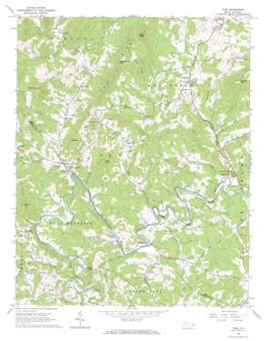
Todd Topo Map North Carolina
To zoom in, hover over the map of Todd
USGS Topo Quad 36081c5 - 1:24,000 scale
| Topo Map Name: | Todd |
| USGS Topo Quad ID: | 36081c5 |
| Print Size: | ca. 21 1/4" wide x 27" high |
| Southeast Coordinates: | 36.25° N latitude / 81.5° W longitude |
| Map Center Coordinates: | 36.3125° N latitude / 81.5625° W longitude |
| U.S. State: | NC |
| Filename: | o36081c5.jpg |
| Download Map JPG Image: | Todd topo map 1:24,000 scale |
| Map Type: | Topographic |
| Topo Series: | 7.5´ |
| Map Scale: | 1:24,000 |
| Source of Map Images: | United States Geological Survey (USGS) |
| Alternate Map Versions: |
Todd NC 1966, updated 1968 Download PDF Buy paper map Todd NC 1966, updated 1984 Download PDF Buy paper map Todd NC 1998, updated 1999 Download PDF Buy paper map Todd NC 2010 Download PDF Buy paper map Todd NC 2013 Download PDF Buy paper map Todd NC 2016 Download PDF Buy paper map |
1:24,000 Topo Quads surrounding Todd
> Back to 36081a1 at 1:100,000 scale
> Back to 36080a1 at 1:250,000 scale
> Back to U.S. Topo Maps home
Todd topo map: Gazetteer
Todd: Dams
Fleetwood Falls Dam elevation 952m 3123′Todd: Gaps
Laurel Knob Gap elevation 1126m 3694′Todd: Islands
Grassy Island elevation 891m 2923′Todd: Populated Places
Baldwin elevation 945m 3100′Brookside (historical) elevation 930m 3051′
Brownwood elevation 891m 2923′
Fleetwood elevation 876m 2874′
Mill Creek elevation 960m 3149′
Moretz elevation 967m 3172′
Solo elevation 991m 3251′
Todd elevation 909m 2982′
Toliver elevation 981m 3218′
Woodford elevation 980m 3215′
Todd: Reservoirs
Fleetwood Falls Lake elevation 952m 3123′Todd: Ridges
Bee Ridge elevation 1297m 4255′Elk Ridge elevation 1358m 4455′
Little Elk Ridge elevation 999m 3277′
Queen Ridge elevation 1084m 3556′
Todd: Streams
Call Creek elevation 877m 2877′Couches Creek elevation 872m 2860′
Cranberry Creek elevation 881m 2890′
Elk Creek elevation 896m 2939′
Grassy Creek elevation 906m 2972′
Little Elk Creek elevation 894m 2933′
Little Gap Creek elevation 876m 2874′
Meadow Creek elevation 886m 2906′
Mill Creek elevation 882m 2893′
Old Fields Creek elevation 872m 2860′
Pine Orchard Creek elevation 906m 2972′
Todd: Summits
Bald Mountain elevation 1509m 4950′Black Mountain elevation 1411m 4629′
Laurel Knob Mountain elevation 1386m 4547′
Laurence Knob elevation 1088m 3569′
Mulatto Mountain elevation 1312m 4304′
Rich Mountain elevation 1202m 3943′
Stone Mountain elevation 1207m 3959′
Third Knob elevation 1197m 3927′
Todd digital topo map on disk
Buy this Todd topo map showing relief, roads, GPS coordinates and other geographical features, as a high-resolution digital map file on DVD:
Western Virginia & Southern West Virginia
Buy digital topo maps: Western Virginia & Southern West Virginia


