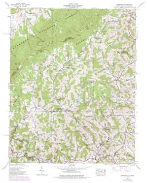
Sherwood Topo Map North Carolina
To zoom in, hover over the map of Sherwood
USGS Topo Quad 36081c7 - 1:24,000 scale
| Topo Map Name: | Sherwood |
| USGS Topo Quad ID: | 36081c7 |
| Print Size: | ca. 21 1/4" wide x 27" high |
| Southeast Coordinates: | 36.25° N latitude / 81.75° W longitude |
| Map Center Coordinates: | 36.3125° N latitude / 81.8125° W longitude |
| U.S. States: | NC, TN |
| Filename: | o36081c7.jpg |
| Download Map JPG Image: | Sherwood topo map 1:24,000 scale |
| Map Type: | Topographic |
| Topo Series: | 7.5´ |
| Map Scale: | 1:24,000 |
| Source of Map Images: | United States Geological Survey (USGS) |
| Alternate Map Versions: |
Sherwood NC 1935 Download PDF Buy paper map Sherwood NC 1938 Download PDF Buy paper map Sherwood NC 1938, updated 1956 Download PDF Buy paper map Sherwood NC 1938, updated 1964 Download PDF Buy paper map Sherwood NC 1938, updated 1971 Download PDF Buy paper map Sherwood NC 1938, updated 1976 Download PDF Buy paper map Sherwood NC 1994, updated 1998 Download PDF Buy paper map Sherwood NC 2011 Download PDF Buy paper map Sherwood NC 2013 Download PDF Buy paper map Sherwood NC 2016 Download PDF Buy paper map |
| FStopo: | US Forest Service topo Sherwood is available: Download FStopo PDF Download FStopo TIF |
1:24,000 Topo Quads surrounding Sherwood
> Back to 36081a1 at 1:100,000 scale
> Back to 36080a1 at 1:250,000 scale
> Back to U.S. Topo Maps home
Sherwood topo map: Gazetteer
Sherwood: Bridges
Greer Bridge elevation 786m 2578′Sherwood: Crossings
Greer Ford elevation 786m 2578′Sherwood: Falls
Laurel Creek Falls elevation 804m 2637′Watauga Falls elevation 781m 2562′
Sherwood: Gaps
Baker Gap elevation 1163m 3815′Baker Gap elevation 1163m 3815′
George Gap elevation 1050m 3444′
Locust Gap elevation 1136m 3727′
Locust Gap elevation 1136m 3727′
State Line Gap elevation 1144m 3753′
State Line Gap elevation 1142m 3746′
Vaught Gap elevation 1230m 4035′
Vaught Gap elevation 1228m 4028′
Ward Gap elevation 1042m 3418′
Sherwood: Mines
Wilson Hill Mine elevation 779m 2555′Sherwood: Populated Places
Amantha elevation 829m 2719′Bethel elevation 824m 2703′
Center View elevation 904m 2965′
Forest Grove elevation 879m 2883′
Leander elevation 818m 2683′
Mabel elevation 905m 2969′
Mill Creek elevation 693m 2273′
North Fork elevation 959m 3146′
Reese elevation 927m 3041′
Sherwood elevation 821m 2693′
Silverstone elevation 879m 2883′
Sugar Grove elevation 816m 2677′
Sweetwater elevation 844m 2769′
Watauga Falls (historical) elevation 808m 2650′
Sherwood: Ridges
Beaverdam Ridge elevation 1018m 3339′Bee Tree Ridge elevation 1006m 3300′
Fork Ridge elevation 1277m 4189′
Frozenhead Ridge elevation 1045m 3428′
Hockiday Ridge elevation 969m 3179′
Horse Ridge elevation 1030m 3379′
Ivory Ridge elevation 1037m 3402′
Line Ridge elevation 1206m 3956′
Lost Ridge elevation 1111m 3645′
Snake Den Ridge elevation 1047m 3435′
State Line Ridge elevation 1199m 3933′
Terman Ridge elevation 1044m 3425′
Terman Ridge elevation 1045m 3428′
Sherwood: Streams
Beaverdam Creek elevation 768m 2519′Brushy Fork elevation 811m 2660′
Bulldog Creek elevation 901m 2956′
Bulldog Creek elevation 890m 2919′
Buttermilk Branch elevation 934m 3064′
Cornett Branch elevation 924m 3031′
Drake Branch elevation 895m 2936′
Drake Branch elevation 899m 2949′
Eager Branch elevation 925m 3034′
East Fork Cove Creek elevation 803m 2634′
East Fork Furnace Creek elevation 1010m 3313′
East Fork Furnance Creek elevation 1006m 3300′
Egger Branch elevation 924m 3031′
Ellison Branch elevation 892m 2926′
Forest Grove Creek elevation 848m 2782′
Fork Branch elevation 851m 2791′
George Gap Branch elevation 815m 2673′
Jones Branch elevation 948m 3110′
Kirby Branch elevation 863m 2831′
Laurel Branch elevation 841m 2759′
Laurel Creek elevation 782m 2565′
Little Beaverdam Creek elevation 838m 2749′
Long Branch elevation 877m 2877′
North Fork Cove Creek elevation 891m 2923′
North Fork Ellison Branch elevation 940m 3083′
North Fork Sawyer Creek elevation 884m 2900′
Phillips Branch elevation 817m 2680′
Rube Creek elevation 817m 2680′
Rush Branch elevation 770m 2526′
Sawyer Creek elevation 857m 2811′
Sharp Creek elevation 844m 2769′
South Fork Ellison Branch elevation 942m 3090′
Vanderpool Creek elevation 820m 2690′
West Fork Buttermilk Branch elevation 947m 3106′
West Fork Buttermilk Branch elevation 936m 3070′
West Fork Rube Creek elevation 854m 2801′
Sherwood: Summits
Buckeye Knob elevation 1333m 4373′Crossing Knob elevation 1018m 3339′
Dyer Knob elevation 1043m 3421′
Love Knob elevation 1125m 3690′
Prophet Knob elevation 1178m 3864′
The Bald elevation 1416m 4645′
The Bald elevation 1410m 4625′
Sherwood: Valleys
Fletcher Hollow elevation 829m 2719′Henson Hollow elevation 840m 2755′
Isaac Hollow elevation 821m 2693′
Ward Hollow elevation 799m 2621′
Warren Hollow elevation 947m 3106′
Wilson Hollow elevation 938m 3077′
Sherwood digital topo map on disk
Buy this Sherwood topo map showing relief, roads, GPS coordinates and other geographical features, as a high-resolution digital map file on DVD:
Western Virginia & Southern West Virginia
Buy digital topo maps: Western Virginia & Southern West Virginia


