Laurel Bloomery Topo Map Tennessee
To zoom in, hover over the map of Laurel Bloomery
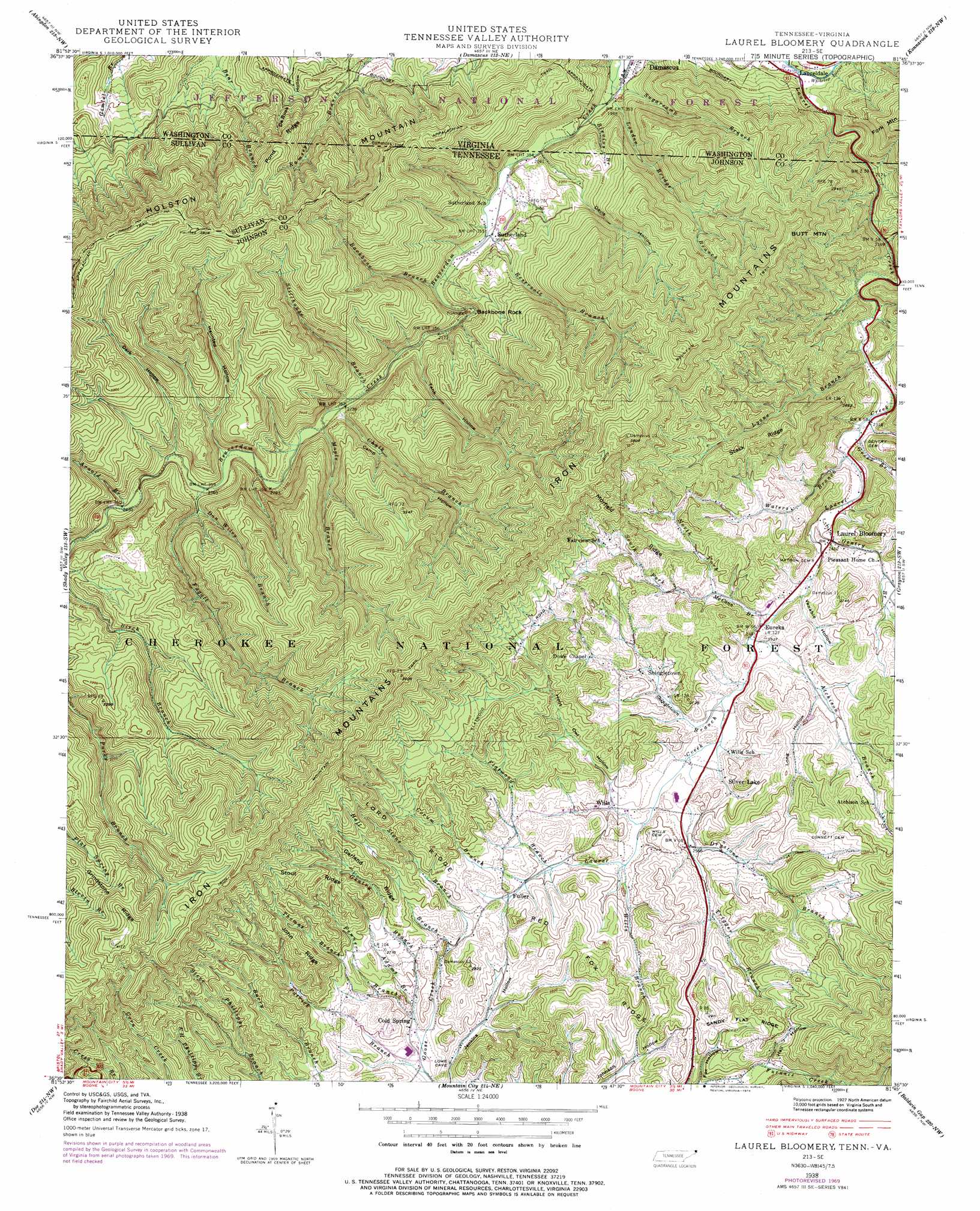
USGS Topo Quad 36081e7 - 1:24,000 scale
| Topo Map Name: | Laurel Bloomery |
| USGS Topo Quad ID: | 36081e7 |
| Print Size: | ca. 21 1/4" wide x 27" high |
| Southeast Coordinates: | 36.5° N latitude / 81.75° W longitude |
| Map Center Coordinates: | 36.5625° N latitude / 81.8125° W longitude |
| U.S. States: | TN, VA |
| Filename: | o36081e7.jpg |
| Download Map JPG Image: | Laurel Bloomery topo map 1:24,000 scale |
| Map Type: | Topographic |
| Topo Series: | 7.5´ |
| Map Scale: | 1:24,000 |
| Source of Map Images: | United States Geological Survey (USGS) |
| Alternate Map Versions: |
Laurel Bloomery TN 1935 Download PDF Buy paper map Laurel Bloomery TN 1938 Download PDF Buy paper map Laurel Bloomery TN 1938, updated 1956 Download PDF Buy paper map Laurel Bloomery TN 1938, updated 1967 Download PDF Buy paper map Laurel Bloomery TN 1938, updated 1971 Download PDF Buy paper map Laurel Bloomery TN 1938, updated 1974 Download PDF Buy paper map Laurel Bloomery TN 2011 Download PDF Buy paper map Laurel Bloomery TN 2013 Download PDF Buy paper map Laurel Bloomery TN 2016 Download PDF Buy paper map |
| FStopo: | US Forest Service topo Laurel Bloomery is available: Download FStopo PDF Download FStopo TIF |
1:24,000 Topo Quads surrounding Laurel Bloomery
Brumley |
Hayters Gap |
Glade Spring |
Chilhowie |
Marion |
Wyndale |
Abingdon |
Damascus |
Konnarock |
Whitetop Mountain |
Holston Valley |
Shady Valley |
Laurel Bloomery |
Grayson |
Park |
Carter |
Doe |
Mountain City |
Baldwin Gap |
Warrensville |
Watauga Dam |
Elk Mills |
Sherwood |
Zionville |
Todd |
> Back to 36081e1 at 1:100,000 scale
> Back to 36080a1 at 1:250,000 scale
> Back to U.S. Topo Maps home
Laurel Bloomery topo map: Gazetteer
Laurel Bloomery: Gaps
Parks Gap elevation 979m 3211′Laurel Bloomery: Mines
Camp Hollow Mine elevation 856m 2808′Chalk Branch Prospect elevation 941m 3087′
East Tank Hollow Prospect elevation 807m 2647′
Hawkins Prospect elevation 763m 2503′
Hogback Mine elevation 883m 2896′
Neely Mine elevation 805m 2641′
Parks Gap Prospect elevation 985m 3231′
Reynolds Mine elevation 696m 2283′
Scott Prospect elevation 889m 2916′
Sebert Prospect elevation 680m 2230′
Sheets Prospect elevation 894m 2933′
Silver Lake Mine elevation 773m 2536′
State Line Mine elevation 714m 2342′
Ward Mine elevation 937m 3074′
West Tank Hollow Prospect elevation 839m 2752′
Wills Mine elevation 798m 2618′
Laurel Bloomery: Parks
Backbone Rock Recreation Area elevation 657m 2155′Laurel Bloomery: Pillars
Backbone Rock elevation 649m 2129′Laurel Bloomery: Populated Places
Cold Spring elevation 768m 2519′Eureka elevation 743m 2437′
Fuller elevation 803m 2634′
Laurel Bloomery elevation 735m 2411′
Laureldale elevation 612m 2007′
Shingletown elevation 778m 2552′
Silver Lake elevation 766m 2513′
Sutherland elevation 637m 2089′
Wills elevation 782m 2565′
Laurel Bloomery: Post Offices
Laurel Bloomery Post Office elevation 735m 2411′Laurel Bloomery: Ridges
Garland Ridge elevation 941m 3087′Grindstone Ridge elevation 1091m 3579′
John Ridge elevation 923m 3028′
Lord Ridge elevation 921m 3021′
Morfield Ridge elevation 876m 2874′
Pond Ridge elevation 895m 2936′
Pond Ridge elevation 930m 3051′
Red Fox Ridge elevation 868m 2847′
Sandy Flat Ridge elevation 884m 2900′
Stack Ridge elevation 896m 2939′
Stout Ridge elevation 1017m 3336′
Laurel Bloomery: Streams
Adams Branch elevation 770m 2526′Arnold Branch elevation 739m 2424′
Atchison Branch elevation 744m 2440′
Backbone Branch elevation 646m 2119′
Blevins Branch elevation 607m 1991′
Chalk Branch elevation 677m 2221′
Corum Branch elevation 794m 2604′
Dan Wiley Branch elevation 705m 2312′
Dry Branch elevation 759m 2490′
Drystone Branch elevation 780m 2559′
Elliot Branch elevation 658m 2158′
Fagall Branch elevation 718m 2355′
Fenner Branch elevation 762m 2500′
Flatwood Branch elevation 785m 2575′
Gentry Branch elevation 757m 2483′
Gentry Creek elevation 725m 2378′
Greer Branch elevation 704m 2309′
Hall Branch elevation 785m 2575′
Laurel Creek elevation 610m 2001′
Lick Branch elevation 702m 2303′
London Bridge Branch elevation 604m 1981′
Lyons Branch elevation 694m 2276′
Maple Branch elevation 697m 2286′
McCann Branch elevation 741m 2431′
North Fork Gentry Creek elevation 748m 2454′
North Fork McCann Branch elevation 760m 2493′
Patrick Branch elevation 754m 2473′
Reservoir Branch elevation 637m 2089′
Shingletown Branch elevation 756m 2480′
South Fork Furnace Creek elevation 890m 2919′
South Fork McCann Branch elevation 760m 2493′
Stillhouse Branch elevation 681m 2234′
Stone Branch elevation 783m 2568′
Sugarcamp Branch elevation 722m 2368′
Sugarcamp Branch elevation 601m 1971′
Thomas Branch elevation 786m 2578′
Trigger Branch elevation 761m 2496′
Waters Branch elevation 710m 2329′
Whitetop Laurel Creek elevation 609m 1998′
Wills Branch elevation 772m 2532′
Laurel Bloomery: Summits
Butt Mountain elevation 1062m 3484′Laurel Bloomery: Valleys
Camp Hollow elevation 693m 2273′Dark Hollow elevation 733m 2404′
Davis Hollow elevation 637m 2089′
Fox Hollow elevation 823m 2700′
Hall Hollow elevation 840m 2755′
Haunted Hollow elevation 718m 2355′
Hoot Owl Hollow elevation 783m 2568′
Long Hollow elevation 779m 2555′
Negro Grave Hollow elevation 711m 2332′
Tank Hollow elevation 668m 2191′
Venable Hollow elevation 742m 2434′
Laurel Bloomery digital topo map on disk
Buy this Laurel Bloomery topo map showing relief, roads, GPS coordinates and other geographical features, as a high-resolution digital map file on DVD:
Western Virginia & Southern West Virginia
Buy digital topo maps: Western Virginia & Southern West Virginia