Trout Dale Topo Map Virginia
To zoom in, hover over the map of Trout Dale
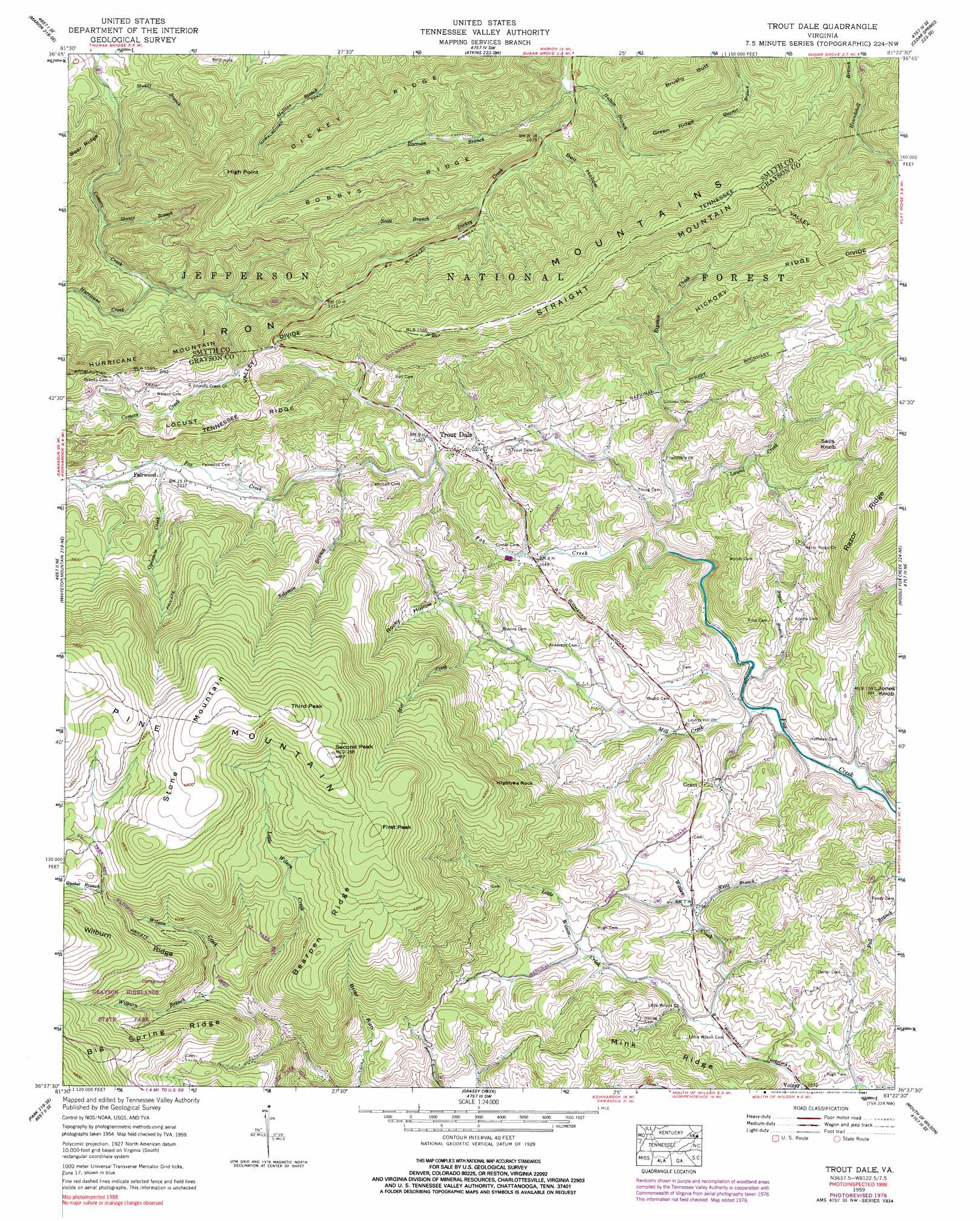
USGS Topo Quad 36081f4 - 1:24,000 scale
| Topo Map Name: | Trout Dale |
| USGS Topo Quad ID: | 36081f4 |
| Print Size: | ca. 21 1/4" wide x 27" high |
| Southeast Coordinates: | 36.625° N latitude / 81.375° W longitude |
| Map Center Coordinates: | 36.6875° N latitude / 81.4375° W longitude |
| U.S. State: | VA |
| Filename: | o36081f4.jpg |
| Download Map JPG Image: | Trout Dale topo map 1:24,000 scale |
| Map Type: | Topographic |
| Topo Series: | 7.5´ |
| Map Scale: | 1:24,000 |
| Source of Map Images: | United States Geological Survey (USGS) |
| Alternate Map Versions: |
Trout Dale VA 1935 Download PDF Buy paper map Trout Dale VA 1959, updated 1960 Download PDF Buy paper map Trout Dale VA 1959, updated 1969 Download PDF Buy paper map Trout Dale VA 1959, updated 1978 Download PDF Buy paper map Trout Dale VA 1959, updated 1991 Download PDF Buy paper map Trout Dale VA 2000, updated 2001 Download PDF Buy paper map Trout Dale VA 2011 Download PDF Buy paper map Trout Dale VA 2013 Download PDF Buy paper map Trout Dale VA 2016 Download PDF Buy paper map |
| FStopo: | US Forest Service topo Trout Dale is available: Download FStopo PDF Download FStopo TIF |
1:24,000 Topo Quads surrounding Trout Dale
Broadford |
Chatham Hill |
Nebo |
Rural Retreat |
Crockett |
Chilhowie |
Marion |
Atkins |
Cedar Springs |
Speedwell |
Konnarock |
Whitetop Mountain |
Trout Dale |
Middle Fox Creek |
Elk Creek |
Grayson |
Park |
Grassy Creek |
Mouth Of Wilson |
Sparta West |
Baldwin Gap |
Warrensville |
Jefferson |
Laurel Springs |
Whitehead |
> Back to 36081e1 at 1:100,000 scale
> Back to 36080a1 at 1:250,000 scale
> Back to U.S. Topo Maps home
Trout Dale topo map: Gazetteer
Trout Dale: Dams
Laurel Creek Dam elevation 1111m 3645′Trout Dale: Gaps
Dickey Gap elevation 1003m 3290′Trout Dale: Parks
Mount Rogers National Recreation Area elevation 941m 3087′Trout Dale: Pillars
Hightree Rock elevation 1185m 3887′Trout Dale: Populated Places
Fairwood elevation 1021m 3349′Grant elevation 860m 2821′
Trout Dale elevation 949m 3113′
Volney elevation 800m 2624′
Trout Dale: Ridges
Bearpen Ridge elevation 1280m 4199′Big Spring Ridge elevation 1293m 4242′
Bobbys Ridge elevation 1106m 3628′
Dickey Ridge elevation 1110m 3641′
Green Ridge elevation 1111m 3645′
Hickory Ridge elevation 1100m 3608′
Locust Ridge elevation 1148m 3766′
Mink Ridge elevation 940m 3083′
Snake Den Ridge elevation 1028m 3372′
Wilburn Ridge elevation 1440m 4724′
Trout Dale: Streams
Big Wilson Creek elevation 1316m 4317′Hurricane Creek elevation 844m 2769′
Hutton Branch elevation 839m 2752′
Laurel Creek elevation 833m 2732′
Little Wilson Creek elevation 1066m 3497′
Little Wilson Creek elevation 801m 2627′
Mill Creek elevation 787m 2582′
Muddy Branch elevation 771m 2529′
Opossum Creek elevation 1019m 3343′
Quebec Branch elevation 1282m 4206′
Raccoon Branch elevation 834m 2736′
Ripshin Creek elevation 855m 2805′
Scott Branch elevation 898m 2946′
Shanty Branch elevation 822m 2696′
Solomon Branch elevation 951m 3120′
Sugar Branch elevation 792m 2598′
Wallen Creek elevation 819m 2687′
Weiss Branch elevation 846m 2775′
Wilburn Branch elevation 1082m 3549′
Trout Dale: Summits
Brushy Butt elevation 1084m 3556′First Peak elevation 1405m 4609′
High Point elevation 1225m 4019′
Jones Knob elevation 952m 3123′
Second Peak elevation 1476m 4842′
Sells Knob elevation 1099m 3605′
Stone Mountain elevation 1503m 4931′
Straight Mountain elevation 1256m 4120′
Third Peak elevation 1502m 4927′
Upper Sharp Knob elevation 1161m 3809′
Trout Dale: Trails
Bearpen Trail elevation 1365m 4478′Bobby's Trail elevation 1058m 3471′
Comers Creek Trail elevation 847m 2778′
First Peak Trail elevation 1490m 4888′
Hickory Ridge Trail elevation 1088m 3569′
Hurricane Creek Trail elevation 892m 2926′
Mullins Branch Trail elevation 1067m 3500′
Scales Trail elevation 1395m 4576′
Switchback Trail elevation 1144m 3753′
Third Peak Trail elevation 1361m 4465′
Trout Dale: Valleys
Bell Hollow elevation 873m 2864′Fairwood Valley elevation 955m 3133′
Rocky Hollow elevation 966m 3169′
Trout Dale digital topo map on disk
Buy this Trout Dale topo map showing relief, roads, GPS coordinates and other geographical features, as a high-resolution digital map file on DVD:
Western Virginia & Southern West Virginia
Buy digital topo maps: Western Virginia & Southern West Virginia