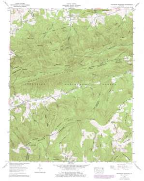
Whitetop Mountain Topo Map Virginia
To zoom in, hover over the map of Whitetop Mountain
USGS Topo Quad 36081f5 - 1:24,000 scale
| Topo Map Name: | Whitetop Mountain |
| USGS Topo Quad ID: | 36081f5 |
| Print Size: | ca. 21 1/4" wide x 27" high |
| Southeast Coordinates: | 36.625° N latitude / 81.5° W longitude |
| Map Center Coordinates: | 36.6875° N latitude / 81.5625° W longitude |
| U.S. State: | VA |
| Filename: | o36081f5.jpg |
| Download Map JPG Image: | Whitetop Mountain topo map 1:24,000 scale |
| Map Type: | Topographic |
| Topo Series: | 7.5´ |
| Map Scale: | 1:24,000 |
| Source of Map Images: | United States Geological Survey (USGS) |
| Alternate Map Versions: |
Whitetop Mountain VA 1935 Download PDF Buy paper map Whitetop Mountain VA 1959, updated 1960 Download PDF Buy paper map Whitetop Mountain VA 1959, updated 1960 Download PDF Buy paper map Whitetop Mountain VA 1959, updated 1969 Download PDF Buy paper map Whitetop Mountain VA 1959, updated 1978 Download PDF Buy paper map Whitetop Mountain VA 2000, updated 2001 Download PDF Buy paper map Whitetop Mountain VA 2011 Download PDF Buy paper map Whitetop Mountain VA 2013 Download PDF Buy paper map Whitetop Mountain VA 2016 Download PDF Buy paper map |
| FStopo: | US Forest Service topo Whitetop Mountain is available: Download FStopo PDF Download FStopo TIF |
1:24,000 Topo Quads surrounding Whitetop Mountain
> Back to 36081e1 at 1:100,000 scale
> Back to 36080a1 at 1:250,000 scale
> Back to U.S. Topo Maps home
Whitetop Mountain topo map: Gazetteer
Whitetop Mountain: Bends
Horseshoe Bend elevation 938m 3077′Whitetop Mountain: Gaps
Barton Gap elevation 969m 3179′Deep Gap elevation 1496m 4908′
Hurricane Gap elevation 1151m 3776′
Massie Gap elevation 1480m 4855′
Skulls Gap elevation 1063m 3487′
Whitetop Mountain: Populated Places
Dry Fork elevation 728m 2388′Stony Battery elevation 749m 2457′
Whitetop Mountain: Ridges
Barlow Ridge elevation 1041m 3415′Bear Ridge elevation 1102m 3615′
Bills Ridge elevation 1295m 4248′
Brier Ridge elevation 1511m 4957′
Cabin Ridge elevation 1517m 4977′
Chestnut Ridge elevation 1134m 3720′
Daves Ridge elevation 1218m 3996′
Elk Garden Ridge elevation 1514m 4967′
Elk Ridge elevation 1429m 4688′
Long Ridge elevation 892m 2926′
Pine Spur elevation 980m 3215′
Plummer Ridge elevation 1037m 3402′
Whitetop Mountain: Springs
Lewis Spring elevation 739m 2424′Whitetop Mountain: Streams
Bark Camp Branch elevation 780m 2559′Big Branch elevation 930m 3051′
Charles Branch elevation 973m 3192′
Cold Branch elevation 822m 2696′
Daves Branch elevation 954m 3129′
East Fork Hopkins Branch elevation 754m 2473′
Grassy Branch elevation 1029m 3375′
Grindstone Branch elevation 1083m 3553′
Lewis Fork elevation 1071m 3513′
Mile Branch elevation 745m 2444′
West Fork Hopkins Branch elevation 754m 2473′
Whitetop Mountain: Summits
Bald Knob elevation 992m 3254′Balsam Mountain elevation 1403m 4603′
Buzzard Rock elevation 1553m 5095′
Double Top elevation 1382m 4534′
Flat Top elevation 1341m 4399′
Grave Mountain elevation 1331m 4366′
Haw Orchard Mountain elevation 1526m 5006′
High Point elevation 1115m 3658′
Hurricane Mountain elevation 1355m 4445′
Mount Rogers elevation 1744m 5721′
Pine Mountain elevation 1684m 5524′
Round Top elevation 1215m 3986′
Seng Mountain elevation 1106m 3628′
Sharp Top elevation 1316m 4317′
Whitetop Mountain elevation 1684m 5524′
Whitetop Mountain: Trails
Cliffside Trail elevation 1198m 3930′Elk Garden Trail elevation 1251m 4104′
Grassy Branch Trail elevation 1145m 3756′
Helton Creek Trail elevation 1317m 4320′
Lewis Fork Trail elevation 1194m 3917′
Mount Rogers Spur elevation 1690m 5544′
Mount Rogers Trail elevation 1145m 3756′
Old Orchard Trail elevation 1133m 3717′
Sugar Maple Trail elevation 1407m 4616′
Whitetop Mountain: Valleys
Bell Hollow elevation 695m 2280′Incline Hollow elevation 922m 3024′
Whitetop Mountain digital topo map on disk
Buy this Whitetop Mountain topo map showing relief, roads, GPS coordinates and other geographical features, as a high-resolution digital map file on DVD:
Western Virginia & Southern West Virginia
Buy digital topo maps: Western Virginia & Southern West Virginia


