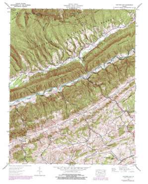
Hayters Gap Topo Map Virginia
To zoom in, hover over the map of Hayters Gap
USGS Topo Quad 36081g8 - 1:24,000 scale
| Topo Map Name: | Hayters Gap |
| USGS Topo Quad ID: | 36081g8 |
| Print Size: | ca. 21 1/4" wide x 27" high |
| Southeast Coordinates: | 36.75° N latitude / 81.875° W longitude |
| Map Center Coordinates: | 36.8125° N latitude / 81.9375° W longitude |
| U.S. State: | VA |
| Filename: | o36081g8.jpg |
| Download Map JPG Image: | Hayters Gap topo map 1:24,000 scale |
| Map Type: | Topographic |
| Topo Series: | 7.5´ |
| Map Scale: | 1:24,000 |
| Source of Map Images: | United States Geological Survey (USGS) |
| Alternate Map Versions: |
Hayters Gap VA 1935 Download PDF Buy paper map Hayters Gap VA 1938, updated 1971 Download PDF Buy paper map Hayters Gap VA 1938, updated 1974 Download PDF Buy paper map Hayters Gap VA 1938, updated 1978 Download PDF Buy paper map Hayters Gap VA 1939 Download PDF Buy paper map Hayters Gap VA 1939 Download PDF Buy paper map Hayters Gap VA 2011 Download PDF Buy paper map Hayters Gap VA 2013 Download PDF Buy paper map Hayters Gap VA 2016 Download PDF Buy paper map |
| FStopo: | US Forest Service topo Hayters Gap is available: Download FStopo PDF Download FStopo TIF |
1:24,000 Topo Quads surrounding Hayters Gap
> Back to 36081e1 at 1:100,000 scale
> Back to 36080a1 at 1:250,000 scale
> Back to U.S. Topo Maps home
Hayters Gap topo map: Gazetteer
Hayters Gap: Cliffs
Morrison Cliff elevation 467m 1532′Hayters Gap: Gaps
Hayters Gap elevation 942m 3090′Price Gap elevation 946m 3103′
Hayters Gap: Populated Places
Duncanville elevation 596m 1955′Giesley Mill elevation 629m 2063′
Glenford elevation 571m 1873′
Lindell elevation 579m 1899′
Lowland elevation 566m 1856′
Midway elevation 620m 2034′
Shortsville elevation 645m 2116′
Walker Place elevation 504m 1653′
White Mill elevation 581m 1906′
Hayters Gap: Ranges
Little Mountain elevation 757m 2483′Hayters Gap: Ridges
Brumley Ridge elevation 1220m 4002′Chestnut Ridge elevation 674m 2211′
Hayters Gap: Springs
Yellow Springs elevation 603m 1978′Hayters Gap: Streams
Beetree Branch elevation 491m 1610′Bethany Creek elevation 499m 1637′
Braudy Branch elevation 468m 1535′
Casey Branch elevation 499m 1637′
Cooley Camp Branch elevation 488m 1601′
Count Creek elevation 475m 1558′
Dry Branch elevation 519m 1702′
East Fork Wolf Creek elevation 474m 1555′
Edington Branch elevation 484m 1587′
Finley Creek elevation 461m 1512′
Fullen Branch elevation 469m 1538′
Gobble Branch elevation 456m 1496′
Greenway Branch elevation 652m 2139′
Lee Creek elevation 524m 1719′
Logan Creek elevation 527m 1729′
Maiden Creek elevation 566m 1856′
Mitchell Branch elevation 451m 1479′
Mudlick Branch elevation 508m 1666′
Poston Branch elevation 469m 1538′
Price Creek elevation 482m 1581′
Rich Mountain Creek elevation 530m 1738′
Smyth Branch elevation 601m 1971′
Taylor Branch elevation 482m 1581′
Toole Creek elevation 452m 1482′
Van Hook Branch elevation 489m 1604′
West Fork Wolf Creek elevation 475m 1558′
Whiterock Branch elevation 494m 1620′
Williams Branch elevation 509m 1669′
Wolf Creek elevation 464m 1522′
Yellow Spring Branch elevation 598m 1961′
Hayters Gap: Summits
Middle Knob elevation 1263m 4143′Hayters Gap: Valleys
Barnett Hollow elevation 481m 1578′Casey Hollow elevation 498m 1633′
Edington Cove elevation 806m 2644′
Helton Hollow elevation 457m 1499′
Holt Hollow elevation 493m 1617′
Hurley Hollow elevation 481m 1578′
Lee Hollow elevation 558m 1830′
Scott Cove elevation 582m 1909′
Short Hollow elevation 598m 1961′
Turkey Hollow elevation 485m 1591′
Whiterock Cove elevation 503m 1650′
Wydner Hollow elevation 481m 1578′
Hayters Gap digital topo map on disk
Buy this Hayters Gap topo map showing relief, roads, GPS coordinates and other geographical features, as a high-resolution digital map file on DVD:
Western Virginia & Southern West Virginia
Buy digital topo maps: Western Virginia & Southern West Virginia


