Huntdale Topo Map North Carolina
To zoom in, hover over the map of Huntdale
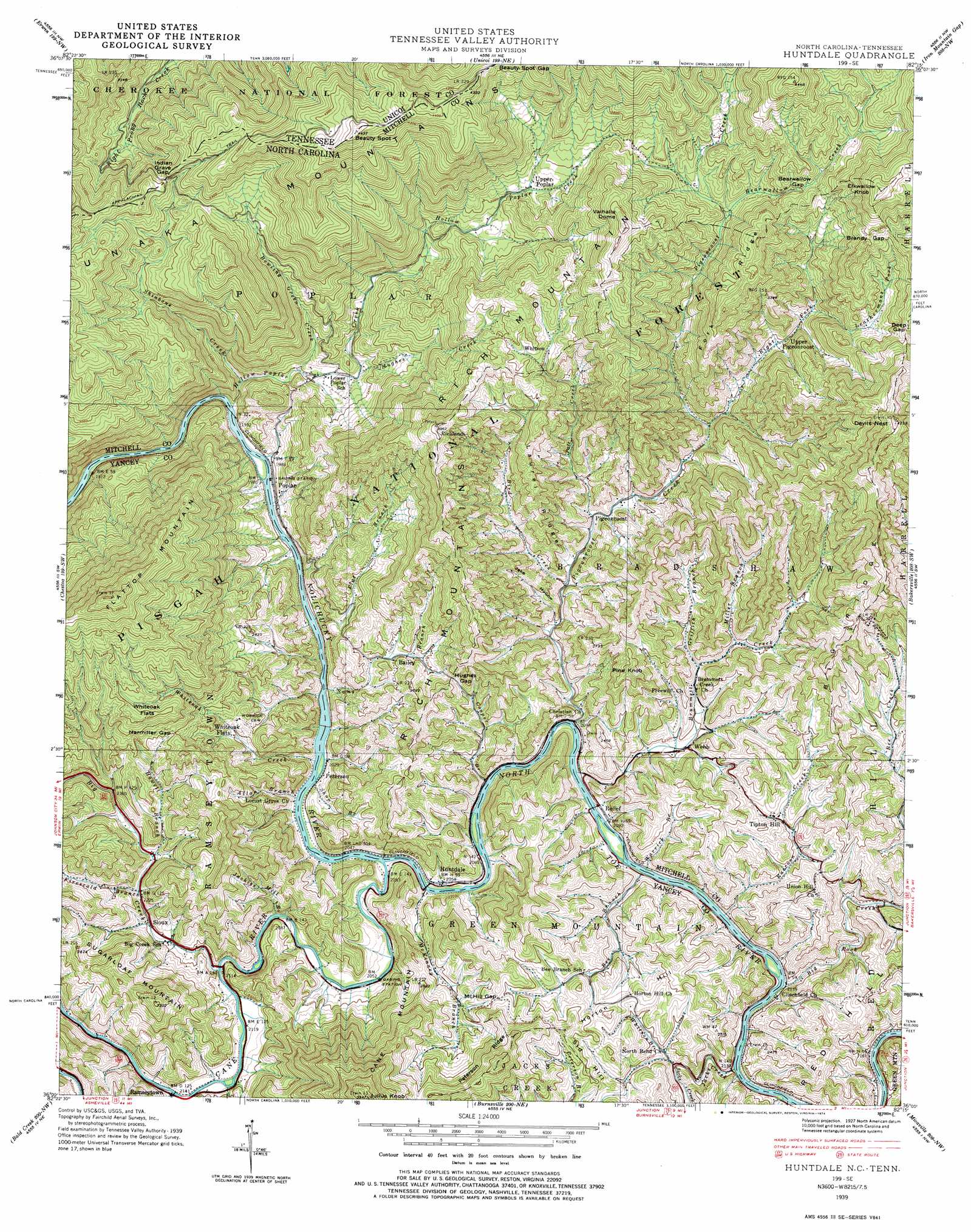
USGS Topo Quad 36082a3 - 1:24,000 scale
| Topo Map Name: | Huntdale |
| USGS Topo Quad ID: | 36082a3 |
| Print Size: | ca. 21 1/4" wide x 27" high |
| Southeast Coordinates: | 36° N latitude / 82.25° W longitude |
| Map Center Coordinates: | 36.0625° N latitude / 82.3125° W longitude |
| U.S. States: | NC, TN |
| Filename: | o36082a3.jpg |
| Download Map JPG Image: | Huntdale topo map 1:24,000 scale |
| Map Type: | Topographic |
| Topo Series: | 7.5´ |
| Map Scale: | 1:24,000 |
| Source of Map Images: | United States Geological Survey (USGS) |
| Alternate Map Versions: |
Huntdale NC 1935 Download PDF Buy paper map Huntdale NC 1939 Download PDF Buy paper map Huntdale NC 1939, updated 1957 Download PDF Buy paper map Huntdale NC 1939, updated 1966 Download PDF Buy paper map Huntdale NC 1939, updated 1974 Download PDF Buy paper map Huntdale NC 1939, updated 1974 Download PDF Buy paper map Huntdale NC 2011 Download PDF Buy paper map Huntdale NC 2013 Download PDF Buy paper map Huntdale NC 2016 Download PDF Buy paper map |
| FStopo: | US Forest Service topo Huntdale is available: Download FStopo PDF Download FStopo TIF |
1:24,000 Topo Quads surrounding Huntdale
Leesburg |
Jonesboro |
Johnson City |
Elizabethton |
Watauga Dam |
Telford |
Erwin |
Unicoi |
Iron Mountain Gap |
White Rocks Mountain |
Flag Pond |
Chestoa |
Huntdale |
Bakersville |
Carvers Gap |
Sams Gap |
Bald Creek |
Burnsville |
Micaville |
Spruce Pine |
Mars Hill |
Barnardsville |
Mount Mitchell |
Celo |
Little Switzerland |
> Back to 36082a1 at 1:100,000 scale
> Back to 36082a1 at 1:250,000 scale
> Back to U.S. Topo Maps home
Huntdale topo map: Gazetteer
Huntdale: Flats
Whiteoak Flats elevation 990m 3248′Huntdale: Gaps
Bearwallow Gap elevation 1058m 3471′Beauty Spot Gap elevation 1240m 4068′
Brandy Gap elevation 1150m 3772′
Deep Gap elevation 1093m 3585′
Harmiller Gap elevation 848m 2782′
Hughes Gap elevation 764m 2506′
Indian Grave Gap elevation 1021m 3349′
Indian Grave Gap elevation 1021m 3349′
McHill Gap elevation 802m 2631′
Huntdale: Populated Places
Bailey elevation 725m 2378′Huntdale elevation 630m 2066′
Peterson elevation 621m 2037′
Pigeonroost elevation 681m 2234′
Poplar elevation 615m 2017′
Ramseytown elevation 651m 2135′
Relief elevation 641m 2103′
Richlands elevation 1056m 3464′
Sioux elevation 694m 2276′
Tipton Hill elevation 735m 2411′
Upper Pigeonroost elevation 851m 2791′
Upper Poplar elevation 937m 3074′
Webb elevation 685m 2247′
Whiteoak Flats elevation 761m 2496′
Whitson elevation 978m 3208′
Huntdale: Ranges
Unaka Mountains elevation 981m 3218′Huntdale: Ridges
Big Ridge elevation 1000m 3280′Fork Ridge elevation 1169m 3835′
Laurel Ridge elevation 888m 2913′
Peterson Ridge elevation 1015m 3330′
Unaka Mountains elevation 1211m 3973′
Huntdale: Streams
Allan Branch elevation 619m 2030′Bearwallow Creek elevation 970m 3182′
Bee Branch elevation 636m 2086′
Big Creek elevation 643m 2109′
Big Rock Creek elevation 641m 2103′
Bird Creek elevation 682m 2237′
Bowling Green Creek elevation 669m 2194′
Brummett Creek elevation 646m 2119′
Cane River elevation 617m 2024′
Cooper Branch elevation 625m 2050′
Firescald Branch elevation 681m 2234′
Flat Branch elevation 614m 2014′
Griffith Branch elevation 691m 2267′
Hollow Poplar Creek elevation 601m 1971′
Howell Branch elevation 692m 2270′
Hughes Creek elevation 693m 2273′
Jackies Mill Branch elevation 636m 2086′
Jacks Creek elevation 651m 2135′
Leathermans Fork elevation 870m 2854′
Mc Kinney Branch elevation 619m 2030′
Miller Branch elevation 714m 2342′
North Cox Creek elevation 645m 2116′
North Toe River elevation 616m 2020′
Pate Creek elevation 685m 2247′
Pigeonroost Creek elevation 634m 2080′
Pigpen Creek elevation 652m 2139′
Pounding Mill Branch elevation 656m 2152′
Raccoon Creek elevation 637m 2089′
Right Fork Pigeonroost Creek elevation 742m 2434′
Sams Branch elevation 617m 2024′
Shinbone Creek elevation 642m 2106′
Shop Branch elevation 626m 2053′
Warrick Branch elevation 642m 2106′
Whiteoak Creek elevation 614m 2014′
Whitson Branch elevation 670m 2198′
Huntdale: Summits
Beauty Spot elevation 1347m 4419′Beauty Spot elevation 1346m 4416′
Devils Nest elevation 1287m 4222′
Elkwallow Knob elevation 1314m 4311′
Green Mountain elevation 744m 2440′
Horton Hill elevation 793m 2601′
Julius Knob elevation 1163m 3815′
Pine Knob elevation 911m 2988′
Red Hill elevation 791m 2595′
Rich Mountain elevation 818m 2683′
Sid Hill elevation 795m 2608′
Valhalla Dome elevation 1226m 4022′
Huntdale: Valleys
Jake Hollow elevation 666m 2185′Huntdale digital topo map on disk
Buy this Huntdale topo map showing relief, roads, GPS coordinates and other geographical features, as a high-resolution digital map file on DVD:
Western Virginia & Southern West Virginia
Buy digital topo maps: Western Virginia & Southern West Virginia