Iron Mountain Gap Topo Map Tennessee
To zoom in, hover over the map of Iron Mountain Gap
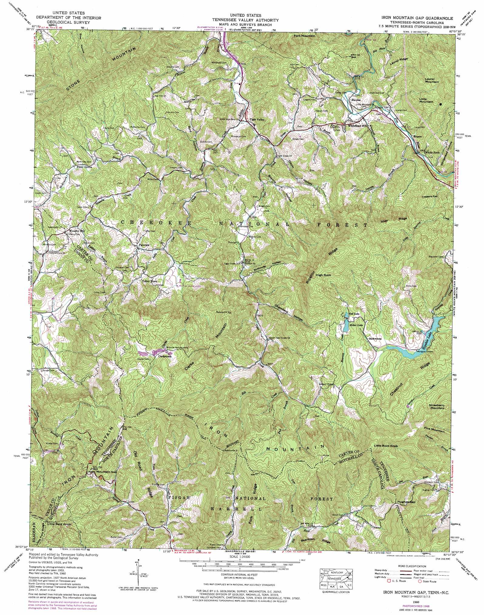
USGS Topo Quad 36082b2 - 1:24,000 scale
| Topo Map Name: | Iron Mountain Gap |
| USGS Topo Quad ID: | 36082b2 |
| Print Size: | ca. 21 1/4" wide x 27" high |
| Southeast Coordinates: | 36.125° N latitude / 82.125° W longitude |
| Map Center Coordinates: | 36.1875° N latitude / 82.1875° W longitude |
| U.S. States: | TN, NC |
| Filename: | o36082b2.jpg |
| Download Map JPG Image: | Iron Mountain Gap topo map 1:24,000 scale |
| Map Type: | Topographic |
| Topo Series: | 7.5´ |
| Map Scale: | 1:24,000 |
| Source of Map Images: | United States Geological Survey (USGS) |
| Alternate Map Versions: |
Iron Mtn Gap TN 1934 Download PDF Buy paper map Iron Mountain Gap TN 1960, updated 1962 Download PDF Buy paper map Iron Mountain Gap TN 1960, updated 1969 Download PDF Buy paper map Iron Mountain Gap TN 1960, updated 1971 Download PDF Buy paper map Iron Mountain Gap TN 1960, updated 1971 Download PDF Buy paper map Iron Mountain Gap TN 2003, updated 2004 Download PDF Buy paper map Iron Mountain Gap TN 2011 Download PDF Buy paper map Iron Mountain Gap TN 2013 Download PDF Buy paper map Iron Mountain Gap TN 2016 Download PDF Buy paper map |
| FStopo: | US Forest Service topo Iron Mountain Gap is available: Download FStopo PDF Download FStopo TIF |
1:24,000 Topo Quads surrounding Iron Mountain Gap
Boone Dam |
Bluff City |
Keenburg |
Carter |
Doe |
Jonesboro |
Johnson City |
Elizabethton |
Watauga Dam |
Elk Mills |
Erwin |
Unicoi |
Iron Mountain Gap |
White Rocks Mountain |
Elk Park |
Chestoa |
Huntdale |
Bakersville |
Carvers Gap |
Newland |
Bald Creek |
Burnsville |
Micaville |
Spruce Pine |
Linville Falls |
> Back to 36082a1 at 1:100,000 scale
> Back to 36082a1 at 1:250,000 scale
> Back to U.S. Topo Maps home
Iron Mountain Gap topo map: Gazetteer
Iron Mountain Gap: Dams
Miller Lake Dam elevation 1103m 3618′Ripshin Dam elevation 1067m 3500′
Iron Mountain Gap: Flats
Loggers Flat elevation 880m 2887′Iron Mountain Gap: Gaps
Hughes Gap elevation 1235m 4051′Hughes Gap elevation 1234m 4048′
Iron Mountain Gap elevation 1136m 3727′
Iron Mountain Gap elevation 1136m 3727′
McKinney Gap elevation 791m 2595′
Iron Mountain Gap: Lakes
Ripshin Lake elevation 1067m 3500′Iron Mountain Gap: Pillars
High Rock elevation 1349m 4425′Iron Mountain Gap: Populated Places
Backwoods elevation 1088m 3569′Blevins elevation 712m 2335′
Clarketown elevation 1058m 3471′
Fairview elevation 788m 2585′
Hopson elevation 717m 2352′
Oak Hill elevation 792m 2598′
Piney Grove elevation 778m 2552′
Plato elevation 809m 2654′
Tiger Valley elevation 619m 2030′
Tolley Town elevation 810m 2657′
White Rock elevation 726m 2381′
Whitehead Hill elevation 738m 2421′
Woodby Hill elevation 791m 2595′
Iron Mountain Gap: Reservoirs
Hall Lake elevation 1104m 3622′Miller Lake elevation 1103m 3618′
Ripshin Lake elevation 1067m 3500′
Iron Mountain Gap: Ridges
Beartown Ridge elevation 1094m 3589′Chestnut Ridge elevation 1224m 4015′
Fork Ridge elevation 1267m 4156′
Iron Mountain elevation 1322m 4337′
Laurel Ridge elevation 808m 2650′
Old Road Ridge elevation 1202m 3943′
Ripshin Ridge elevation 1306m 4284′
River Ridge elevation 1099m 3605′
Road Ridge elevation 1261m 4137′
Iron Mountain Gap: Streams
Big Flats Branch elevation 674m 2211′Bill Creek elevation 963m 3159′
Birchlog Creek elevation 823m 2700′
Browns Branch elevation 579m 1899′
Clarke Creek elevation 761m 2496′
Dave Branch elevation 950m 3116′
Duck Branch elevation 1031m 3382′
Fall Branch elevation 973m 3192′
Fiddlers Branch elevation 765m 2509′
Gouge Branch elevation 646m 2119′
Ingram Branch elevation 715m 2345′
McKinney Branch elevation 708m 2322′
Murray Branch elevation 841m 2759′
Sally Cove Creek elevation 641m 2103′
Simerly Creek elevation 610m 2001′
Simerly Creek elevation 732m 2401′
Tiger Creek elevation 610m 2001′
Toms Creek elevation 917m 3008′
Whitehead Branch elevation 704m 2309′
Iron Mountain Gap: Summits
Clarke Mountain elevation 1250m 4101′Iron Mountain elevation 1295m 4248′
Laurel Mountain elevation 992m 3254′
Little Bald Knob elevation 1359m 4458′
Little Bald Knob elevation 1358m 4455′
Little Mountain elevation 934m 3064′
Little Rock Knob elevation 1499m 4917′
Piney Bald elevation 1277m 4189′
Strawberry Mountain elevation 1347m 4419′
Iron Mountain Gap: Valleys
Blevins Hollow elevation 701m 2299′Byrd Hollow elevation 643m 2109′
Chambers Hollow elevation 867m 2844′
Fiddlers Hollow elevation 771m 2529′
Hogum Hollow elevation 1075m 3526′
Odom Hollow elevation 664m 2178′
Stillhouse Hollow elevation 820m 2690′
Whitehead Hollow elevation 726m 2381′
Iron Mountain Gap digital topo map on disk
Buy this Iron Mountain Gap topo map showing relief, roads, GPS coordinates and other geographical features, as a high-resolution digital map file on DVD:
Western Virginia & Southern West Virginia
Buy digital topo maps: Western Virginia & Southern West Virginia