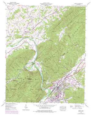
Erwin Topo Map Tennessee
To zoom in, hover over the map of Erwin
USGS Topo Quad 36082b4 - 1:24,000 scale
| Topo Map Name: | Erwin |
| USGS Topo Quad ID: | 36082b4 |
| Print Size: | ca. 21 1/4" wide x 27" high |
| Southeast Coordinates: | 36.125° N latitude / 82.375° W longitude |
| Map Center Coordinates: | 36.1875° N latitude / 82.4375° W longitude |
| U.S. State: | TN |
| Filename: | o36082b4.jpg |
| Download Map JPG Image: | Erwin topo map 1:24,000 scale |
| Map Type: | Topographic |
| Topo Series: | 7.5´ |
| Map Scale: | 1:24,000 |
| Source of Map Images: | United States Geological Survey (USGS) |
| Alternate Map Versions: |
Erwin TN 1935 Download PDF Buy paper map Erwin TN 1939 Download PDF Buy paper map Erwin TN 1939 Download PDF Buy paper map Erwin TN 1939, updated 1954 Download PDF Buy paper map Erwin TN 1939, updated 1972 Download PDF Buy paper map Erwin TN 1939, updated 1977 Download PDF Buy paper map Erwin TN 2003, updated 2004 Download PDF Buy paper map Erwin TN 2011 Download PDF Buy paper map Erwin TN 2013 Download PDF Buy paper map Erwin TN 2016 Download PDF Buy paper map |
| FStopo: | US Forest Service topo Erwin is available: Download FStopo PDF Download FStopo TIF |
1:24,000 Topo Quads surrounding Erwin
> Back to 36082a1 at 1:100,000 scale
> Back to 36082a1 at 1:250,000 scale
> Back to U.S. Topo Maps home
Erwin topo map: Gazetteer
Erwin: Airports
Decker Farm Airport elevation 451m 1479′Erwin: Bars
Bayles First Shoals elevation 454m 1489′Erwin: Bends
The Horseshoe elevation 470m 1541′Erwin: Bridges
Sandy Bottom Bridge (historical) elevation 500m 1640′Taylor Bridge (historical) elevation 451m 1479′
Erwin: Cliffs
Stony Point elevation 564m 1850′Erwin: Crossings
Henleys Ford elevation 455m 1492′Erwin: Dams
Embrees Dam (historical) elevation 460m 1509′Erwin: Gaps
Canah Gap elevation 662m 2171′Horse Cove Gap elevation 732m 2401′
Leach Gap elevation 868m 2847′
Morris Gap elevation 711m 2332′
Organ Gap elevation 806m 2644′
Erwin: Islands
Bend Island elevation 498m 1633′Dedrick Island elevation 451m 1479′
Moore Island elevation 446m 1463′
Erwin: Mines
Davenport Mine elevation 557m 1827′Embree Number 13 Mine elevation 612m 2007′
Embree Number 14 Mine elevation 622m 2040′
Embree Number 15 Mine elevation 596m 1955′
Fowler Mine elevation 547m 1794′
Jackson Mine elevation 519m 1702′
Jewell Prospect elevation 682m 2237′
Klondike Mine elevation 530m 1738′
Little Polly Hollow Mine elevation 566m 1856′
Lower Peedee Mine elevation 541m 1774′
Lower Red Cut Mine elevation 555m 1820′
Number Five Mine elevation 557m 1827′
Number Ten Mine elevation 575m 1886′
Polly Hollow Mine elevation 498m 1633′
Rock Quarry Hollow Mine elevation 656m 2152′
Rock Quarry Hollow Mine elevation 611m 2004′
Sugar Hollow Mine elevation 530m 1738′
Tucker Mine elevation 534m 1751′
Tunnel Mine elevation 668m 2191′
Upper Peedee Mine elevation 550m 1804′
Upper Red Cut Mine elevation 595m 1952′
Warren Prospect elevation 558m 1830′
Yates Hollow Mine elevation 524m 1719′
Erwin: Parks
Unicoi Wildlife Management Area elevation 696m 2283′Erwin: Pillars
Shinbone Rock elevation 543m 1781′Erwin: Populated Places
Banner Hill elevation 511m 1676′Big Cherokee elevation 495m 1624′
Bumpus Cove elevation 542m 1778′
Dry Creek elevation 482m 1581′
Embreeville elevation 487m 1597′
Erwin elevation 510m 1673′
Garber elevation 482m 1581′
Hulan Hollow elevation 539m 1768′
Kansas City elevation 527m 1729′
Lillydale elevation 561m 1840′
Little Cherokee elevation 498m 1633′
Mayday elevation 490m 1607′
Rock Creek elevation 527m 1729′
Erwin: Post Offices
Erwin Post Office elevation 511m 1676′Erwin: Ranges
Buffalo Mountain elevation 837m 2746′Erwin: Ridges
Elephant Back elevation 567m 1860′Embreeville Mountain elevation 747m 2450′
Erwin: Springs
Banner Hill Spring elevation 500m 1640′Birchfield Spring elevation 505m 1656′
Love Spring elevation 518m 1699′
Yates Spring elevation 496m 1627′
Erwin: Streams
Booth Branch elevation 474m 1555′Briar Creek elevation 565m 1853′
Broad Shoal Creek elevation 481m 1578′
Bumpus Cove Creek elevation 468m 1535′
California Creek elevation 492m 1614′
Deacon Creek elevation 473m 1551′
Dry Creek elevation 455m 1492′
Dry Creek elevation 546m 1791′
Fowler Branch elevation 518m 1699′
Harris Branch elevation 527m 1729′
Jewel Branch elevation 588m 1929′
Keplinger Creek elevation 453m 1486′
Little Cherokee Creek elevation 464m 1522′
Loyd Branch elevation 457m 1499′
Martin Creek elevation 494m 1620′
Millstone Creek elevation 458m 1502′
North Indian Creek elevation 488m 1601′
Odom Branch elevation 553m 1814′
Patty Creek elevation 474m 1555′
Ramsey Creek elevation 547m 1794′
Rock Creek elevation 522m 1712′
Rocky Branch elevation 534m 1751′
South Indian Creek elevation 492m 1614′
Spring Branch elevation 500m 1640′
Straight Creek elevation 589m 1932′
Tellico Branch elevation 501m 1643′
Whaley Branch elevation 530m 1738′
Erwin: Summits
Cherokee Knob elevation 836m 2742′Devils Looking Glass elevation 676m 2217′
Green Knob elevation 885m 2903′
Jump Hill elevation 674m 2211′
Looking Glass Mountain elevation 756m 2480′
Erwin: Trails
California Trail elevation 719m 2358′Patty Ridge Trail elevation 798m 2618′
Erwin: Valleys
Ashhopper Hollow elevation 535m 1755′Bumpas Cove elevation 476m 1561′
Bumpus Cove elevation 531m 1742′
Canah Hollow elevation 487m 1597′
Casey Hollow elevation 555m 1820′
Ike White Hollow elevation 480m 1574′
Magazine Hollow elevation 542m 1778′
Number Ten Hollow elevation 499m 1637′
Oak Hollow elevation 499m 1637′
Peedee Hollow elevation 510m 1673′
Pippin Hollow elevation 544m 1784′
Polly Hollow elevation 537m 1761′
Redcut Hollow elevation 521m 1709′
Rock Quarry Hollow elevation 543m 1781′
Starnes Hollow elevation 487m 1597′
Sugar Hollow elevation 501m 1643′
Tipton Hollow elevation 487m 1597′
Van Over Hollow elevation 603m 1978′
Wolf Hollow elevation 531m 1742′
Woodcut Hollow elevation 547m 1794′
Yates Hollow elevation 517m 1696′
Erwin digital topo map on disk
Buy this Erwin topo map showing relief, roads, GPS coordinates and other geographical features, as a high-resolution digital map file on DVD:
Western Virginia & Southern West Virginia
Buy digital topo maps: Western Virginia & Southern West Virginia


