Greeneville Topo Map Tennessee
To zoom in, hover over the map of Greeneville
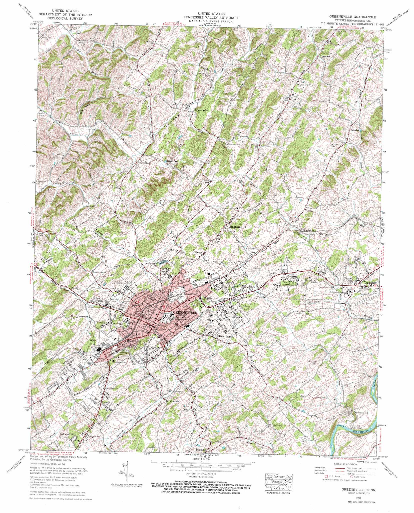
USGS Topo Quad 36082b7 - 1:24,000 scale
| Topo Map Name: | Greeneville |
| USGS Topo Quad ID: | 36082b7 |
| Print Size: | ca. 21 1/4" wide x 27" high |
| Southeast Coordinates: | 36.125° N latitude / 82.75° W longitude |
| Map Center Coordinates: | 36.1875° N latitude / 82.8125° W longitude |
| U.S. State: | TN |
| Filename: | o36082b7.jpg |
| Download Map JPG Image: | Greeneville topo map 1:24,000 scale |
| Map Type: | Topographic |
| Topo Series: | 7.5´ |
| Map Scale: | 1:24,000 |
| Source of Map Images: | United States Geological Survey (USGS) |
| Alternate Map Versions: |
Greeneville TN 1936 Download PDF Buy paper map Greeneville TN 1939, updated 1958 Download PDF Buy paper map Greeneville TN 1940 Download PDF Buy paper map Greeneville TN 1961, updated 1964 Download PDF Buy paper map Greeneville TN 1961, updated 1964 Download PDF Buy paper map Greeneville TN 1961, updated 1965 Download PDF Buy paper map Greeneville TN 2010 Download PDF Buy paper map Greeneville TN 2013 Download PDF Buy paper map Greeneville TN 2016 Download PDF Buy paper map |
1:24,000 Topo Quads surrounding Greeneville
Camelot |
Burem |
Stony Point |
Lovelace |
Sullivan Gardens |
Bulls Gap |
Mccloud |
Baileyton |
Jearoldstown |
Leesburg |
Mohawk |
Mosheim |
Greeneville |
Chuckey |
Telford |
Parrotsville |
Cedar Creek |
Davy Crockett Lake |
Greystone |
Flag Pond |
Neddy Mountain |
Paint Rock |
Hot Springs |
White Rock |
Sams Gap |
> Back to 36082a1 at 1:100,000 scale
> Back to 36082a1 at 1:250,000 scale
> Back to U.S. Topo Maps home
Greeneville topo map: Gazetteer
Greeneville: Airports
Greeneville Municipal Airport elevation 486m 1594′Greeneville: Bars
Alexanders Shoals elevation 380m 1246′Buckinghams Shoals elevation 380m 1246′
Greeneville: Bends
Devils Elbow elevation 436m 1430′Greeneville: Crossings
Buckingham Ford elevation 381m 1250′Greeneville: Lakes
Kidwell Pond elevation 394m 1292′Greeneville: Mines
Berkley Prospect elevation 410m 1345′Britton Prospect elevation 395m 1295′
Cox Prospect elevation 397m 1302′
Harmon Mine elevation 403m 1322′
Harmon Prospect elevation 402m 1318′
Johnson Mine elevation 388m 1272′
Johnson Prospect elevation 420m 1377′
Johnson Prospect elevation 403m 1322′
King Prospect elevation 402m 1318′
Matthews Prospect elevation 408m 1338′
Greeneville: Parks
Andrew Johnson National Historic Site elevation 455m 1492′Forest Park elevation 460m 1509′
Greeneville Historic District elevation 465m 1525′
Tusculum College Historic District elevation 451m 1479′
Greeneville: Populated Places
Alexander Mill elevation 388m 1272′Bolton Estates elevation 497m 1630′
Bradburn Hill elevation 525m 1722′
Buckingham Heights elevation 491m 1610′
Cedar Hill elevation 458m 1502′
Cherrydale elevation 483m 1584′
College Hills elevation 470m 1541′
College View elevation 458m 1502′
Craddock Subdivision elevation 473m 1551′
Derby (historical) elevation 414m 1358′
Dobson Subdivision elevation 468m 1535′
Eastview elevation 476m 1561′
Fairfield elevation 477m 1564′
Fairview elevation 499m 1637′
Forest Hills elevation 485m 1591′
Green Acres elevation 461m 1512′
Greeneville elevation 463m 1519′
Gregory Subdivision elevation 478m 1568′
Harrison Hills elevation 467m 1532′
Hartman Subdivision elevation 403m 1322′
Heritage Hills elevation 452m 1482′
Hickory Hills elevation 470m 1541′
Highland Hills elevation 487m 1597′
Holly Hills elevation 477m 1564′
Home Field Terrace elevation 474m 1555′
Honeys Hill elevation 475m 1558′
Leming Subdivision elevation 442m 1450′
Mays Subdivision elevation 440m 1443′
Meadowlark elevation 442m 1450′
Mountain View Terrace elevation 439m 1440′
Oak Hills elevation 481m 1578′
Pinecrest elevation 446m 1463′
Robinson Forest elevation 493m 1617′
Rockwood Hill elevation 456m 1496′
Rollins Subdivision elevation 438m 1437′
Rustic Acres elevation 450m 1476′
Stowe Acres elevation 478m 1568′
Summey Subdivision elevation 467m 1532′
Sunnyside elevation 452m 1482′
Sunset Acres elevation 463m 1519′
Tanglewood Estates elevation 458m 1502′
Taylor Acres elevation 484m 1587′
Town Acres elevation 465m 1525′
Tusculum elevation 455m 1492′
Tusculum Heights elevation 475m 1558′
Tusculum Place elevation 440m 1443′
Twin Oaks elevation 452m 1482′
Upchurch elevation 475m 1558′
Wedgewood Hills elevation 508m 1666′
Westgate elevation 443m 1453′
Wilhoit Subdivision elevation 445m 1459′
Williams Subdivision elevation 465m 1525′
Willis Subdivision elevation 476m 1561′
Windy Hills elevation 460m 1509′
Greeneville: Post Offices
Greeneville Post Office elevation 466m 1528′Tusculum College Post Office elevation 446m 1463′
Greeneville: Ridges
Jones Ridge elevation 448m 1469′Greeneville: Springs
Brown Spring elevation 376m 1233′Butler Spring elevation 405m 1328′
Moore Spring elevation 473m 1551′
Greeneville: Streams
Frank Creek elevation 432m 1417′Guest Creek elevation 350m 1148′
Holley Creek elevation 382m 1253′
Simpson Creek elevation 424m 1391′
South Fork Roaring Fork elevation 365m 1197′
Tipton Creek elevation 426m 1397′
Wildcat Branch elevation 344m 1128′
Greeneville: Valleys
Big Hollow elevation 351m 1151′Grassy Valley elevation 360m 1181′
Greeneville digital topo map on disk
Buy this Greeneville topo map showing relief, roads, GPS coordinates and other geographical features, as a high-resolution digital map file on DVD:
Western Virginia & Southern West Virginia
Buy digital topo maps: Western Virginia & Southern West Virginia