Baileyton Topo Map Tennessee
To zoom in, hover over the map of Baileyton
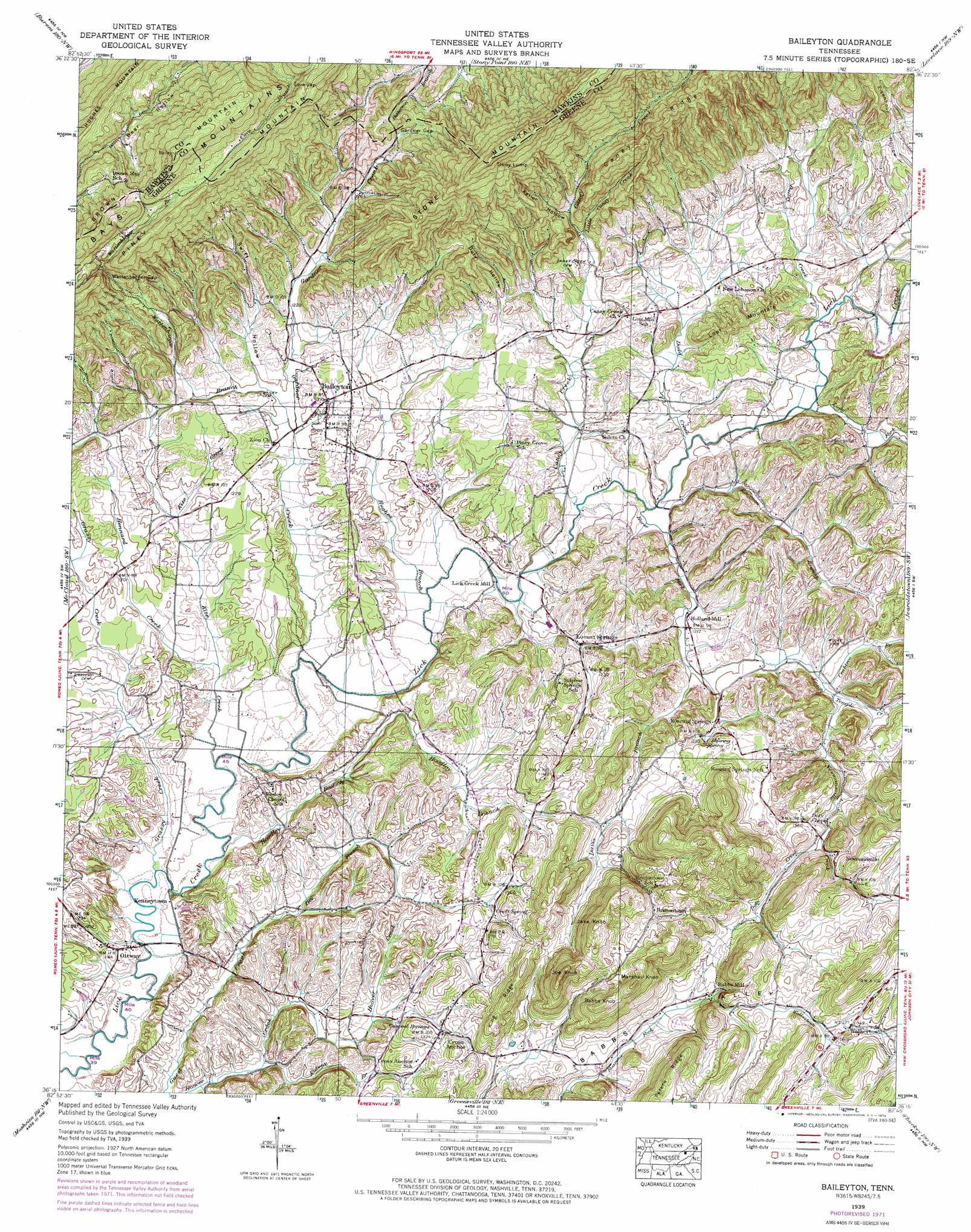
USGS Topo Quad 36082c7 - 1:24,000 scale
| Topo Map Name: | Baileyton |
| USGS Topo Quad ID: | 36082c7 |
| Print Size: | ca. 21 1/4" wide x 27" high |
| Southeast Coordinates: | 36.25° N latitude / 82.75° W longitude |
| Map Center Coordinates: | 36.3125° N latitude / 82.8125° W longitude |
| U.S. State: | TN |
| Filename: | o36082c7.jpg |
| Download Map JPG Image: | Baileyton topo map 1:24,000 scale |
| Map Type: | Topographic |
| Topo Series: | 7.5´ |
| Map Scale: | 1:24,000 |
| Source of Map Images: | United States Geological Survey (USGS) |
| Alternate Map Versions: |
Baileyton TN 1935 Download PDF Buy paper map Baileyton TN 1939, updated 1957 Download PDF Buy paper map Baileyton TN 1939, updated 1972 Download PDF Buy paper map Baileyton TN 1940 Download PDF Buy paper map Baileyton TN 2010 Download PDF Buy paper map Baileyton TN 2013 Download PDF Buy paper map Baileyton TN 2016 Download PDF Buy paper map |
1:24,000 Topo Quads surrounding Baileyton
Kyles Ford |
Looneys Gap |
Plum Grove |
Church Hill |
Kingsport |
Camelot |
Burem |
Stony Point |
Lovelace |
Sullivan Gardens |
Bulls Gap |
Mccloud |
Baileyton |
Jearoldstown |
Leesburg |
Mohawk |
Mosheim |
Greeneville |
Chuckey |
Telford |
Parrotsville |
Cedar Creek |
Davy Crockett Lake |
Greystone |
Flag Pond |
> Back to 36082a1 at 1:100,000 scale
> Back to 36082a1 at 1:250,000 scale
> Back to U.S. Topo Maps home
Baileyton topo map: Gazetteer
Baileyton: Dams
Justis Dam elevation 368m 1207′Lakeview Estates Dam elevation 379m 1243′
Baileyton: Gaps
Cove Gap elevation 490m 1607′Gardner Gap elevation 420m 1377′
Wattenbarger Gap elevation 508m 1666′
Baileyton: Populated Places
Babbs Mill elevation 416m 1364′Baileyton elevation 369m 1210′
Brittontown elevation 466m 1528′
Castell Springs elevation 377m 1236′
Craft Spring elevation 411m 1348′
Holland Mill elevation 367m 1204′
Kenneytown elevation 351m 1151′
Locust Springs elevation 368m 1207′
Mount Hope (historical) elevation 369m 1210′
Newmansville elevation 428m 1404′
Ottway elevation 358m 1174′
Roaring Springs elevation 366m 1200′
Walkertown elevation 474m 1555′
Baileyton: Reservoirs
Justis Lake elevation 368m 1207′Lakeview Estates Lake elevation 379m 1243′
Baileyton: Ridges
Caney Ridge elevation 612m 2007′King Ridge elevation 475m 1558′
Peters Ridge elevation 541m 1774′
Piney Mountain elevation 586m 1922′
Baileyton: Springs
Casteel Springs elevation 378m 1240′Davis Spring elevation 415m 1361′
Roaring Spring elevation 376m 1233′
Baileyton: Streams
Bright Branch elevation 376m 1233′Caney Creek elevation 354m 1161′
Crabtree Branch elevation 370m 1213′
Dailey Creek elevation 364m 1194′
Davis Branch elevation 366m 1200′
Dodd Creek elevation 358m 1174′
Doty Creek elevation 404m 1325′
Dry Branch elevation 364m 1194′
Gardner Creek elevation 347m 1138′
Grassy Creek elevation 343m 1125′
Hennard Creek elevation 349m 1145′
Hoodley Branch elevation 344m 1128′
Horse Fork elevation 356m 1167′
Hughes Branch elevation 350m 1148′
Kidwell Branch elevation 351m 1151′
Kite Creek elevation 346m 1135′
Little Caney Creek elevation 391m 1282′
Long Fork elevation 361m 1184′
Newmansville Creek elevation 370m 1213′
Raccoon Branch elevation 357m 1171′
Union Temple Creek elevation 366m 1200′
Walkertown Branch elevation 444m 1456′
Wattenbarger Branch elevation 359m 1177′
Baileyton: Summits
Babbs Knob elevation 539m 1768′Brown Mountain elevation 659m 2162′
Jake Knob elevation 553m 1814′
Joe Knob elevation 568m 1863′
Lost Mountain elevation 455m 1492′
Marshall Knob elevation 543m 1781′
Stony Lump elevation 766m 2513′
Baileyton: Valleys
Babbs Valley elevation 392m 1286′Doty Hollow elevation 389m 1276′
Keller Hollow elevation 404m 1325′
Swift Hollow elevation 365m 1197′
Baileyton digital topo map on disk
Buy this Baileyton topo map showing relief, roads, GPS coordinates and other geographical features, as a high-resolution digital map file on DVD:
Western Virginia & Southern West Virginia
Buy digital topo maps: Western Virginia & Southern West Virginia