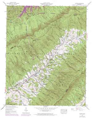
Carter Topo Map Tennessee
To zoom in, hover over the map of Carter
USGS Topo Quad 36082d1 - 1:24,000 scale
| Topo Map Name: | Carter |
| USGS Topo Quad ID: | 36082d1 |
| Print Size: | ca. 21 1/4" wide x 27" high |
| Southeast Coordinates: | 36.375° N latitude / 82° W longitude |
| Map Center Coordinates: | 36.4375° N latitude / 82.0625° W longitude |
| U.S. State: | TN |
| Filename: | o36082d1.jpg |
| Download Map JPG Image: | Carter topo map 1:24,000 scale |
| Map Type: | Topographic |
| Topo Series: | 7.5´ |
| Map Scale: | 1:24,000 |
| Source of Map Images: | United States Geological Survey (USGS) |
| Alternate Map Versions: |
Carter TN 1935 Download PDF Buy paper map Carter TN 1938 Download PDF Buy paper map Carter TN 1938, updated 1954 Download PDF Buy paper map Carter TN 1938, updated 1970 Download PDF Buy paper map Carter TN 1938, updated 1970 Download PDF Buy paper map Carter TN 2003, updated 2004 Download PDF Buy paper map Carter TN 2011 Download PDF Buy paper map Carter TN 2013 Download PDF Buy paper map Carter TN 2016 Download PDF Buy paper map |
| FStopo: | US Forest Service topo Carter is available: Download FStopo PDF Download FStopo TIF |
1:24,000 Topo Quads surrounding Carter
> Back to 36082a1 at 1:100,000 scale
> Back to 36082a1 at 1:250,000 scale
> Back to U.S. Topo Maps home
Carter topo map: Gazetteer
Carter: Gaps
Flint Mill Gap elevation 1014m 3326′Low Gap elevation 1199m 3933′
Turkeypen Gap elevation 1210m 3969′
Carter: Lakes
Boyd Spring Pond (historical) elevation 516m 1692′Carter: Mines
Bear Wallow Mine elevation 867m 2844′Blevins Mine elevation 779m 2555′
Griffith Mine elevation 614m 2014′
Grindstaff Prospect elevation 707m 2319′
Grindstaff Prospect elevation 683m 2240′
Hatcher Prospect elevation 719m 2358′
Hatcher Pyrite Mine elevation 692m 2270′
Helenmode Pyrite Mine elevation 649m 2129′
Hodge Mine elevation 659m 2162′
Jess Heatherly Prospect elevation 689m 2260′
Lipps Ridge Mine elevation 802m 2631′
Middle Ridge Mine elevation 897m 2942′
Nidifer Prospect elevation 736m 2414′
Ritts Ridge Prospect elevation 792m 2598′
Stoutson Quarry elevation 682m 2237′
Taylor Ore Bank Mine elevation 592m 1942′
Taylor Prospect elevation 666m 2185′
Taylor Ridge Mine elevation 883m 2896′
Carter: Pillars
Flint Rock elevation 935m 3067′Carter: Populated Places
Buladeen elevation 680m 2230′Carter elevation 561m 1840′
Housley elevation 628m 2060′
Sadie elevation 606m 1988′
Winner elevation 528m 1732′
Carter: Ridges
Fork Ridge elevation 1044m 3425′Gap Field Ridge elevation 605m 1984′
Grindstaff Ridge elevation 660m 2165′
Horselog Ridge elevation 1085m 3559′
Huckleberry Ridge elevation 1104m 3622′
Lipps Ridge elevation 847m 2778′
Low Hill Ridge elevation 659m 2162′
Peters Ridge elevation 1047m 3435′
Red Eye Ridge elevation 977m 3205′
Ritts Ridge elevation 836m 2742′
Roundabout Ridge elevation 661m 2168′
Taylor Ridge elevation 973m 3192′
Carter: Streams
Bartee Branch elevation 547m 1794′Blackman Branch elevation 670m 2198′
Blevins Branch elevation 642m 2106′
Bowen Branch elevation 702m 2303′
Carter Branch elevation 643m 2109′
Clarion Branch elevation 614m 2014′
Dry Run elevation 526m 1725′
Dugger Branch elevation 627m 2057′
Estep Branch elevation 617m 2024′
Furnace Branch elevation 529m 1735′
George Branch elevation 677m 2221′
Griffith Branch elevation 512m 1679′
Grindstaff Branch elevation 595m 1952′
Ham Branch elevation 659m 2162′
Hannah Branch elevation 730m 2395′
Hickory Flat Branch elevation 715m 2345′
Hinkle Branch elevation 536m 1758′
Hodge Branch elevation 628m 2060′
Holly Springs Branch elevation 621m 2037′
Horselog Branch elevation 568m 1863′
Hurley Branch elevation 615m 2017′
Ike Branch elevation 720m 2362′
Johns Branch elevation 640m 2099′
Laurel Branch elevation 571m 1873′
Left Fork Hurley Branch elevation 741m 2431′
Left Fork Mill Creek elevation 742m 2434′
Left Prong Hodge Branch elevation 734m 2408′
Lick Branch elevation 689m 2260′
Little Flint Mill Branch elevation 652m 2139′
Little Horselog Branch elevation 690m 2263′
Little Marklin Branch elevation 602m 1975′
Lower Nidifer Branch elevation 596m 1955′
Mill Creek elevation 584m 1916′
Miller Branch elevation 549m 1801′
Morrell Creek elevation 1076m 3530′
Muddy Branch elevation 543m 1781′
Nave Branch elevation 575m 1886′
Nidifer Branch elevation 531m 1742′
North Fork Stony Creek elevation 714m 2342′
Peters Branch elevation 559m 1833′
Pierce Branch elevation 519m 1702′
Pierce Branch elevation 552m 1811′
Poe Branch elevation 839m 2752′
Richardson Branch elevation 687m 2253′
Right Fork Hurley Branch elevation 741m 2431′
Right Fork Mill Creek elevation 762m 2500′
Right Prong Hodge Branch elevation 734m 2408′
Roaring Fork elevation 535m 1755′
Rocky Hollow Branch elevation 730m 2395′
Rome Branch elevation 572m 1876′
Stover Branch elevation 584m 1916′
Sulphur Springs Branch elevation 686m 2250′
Taylor Branch elevation 663m 2175′
Upper Hinkle Branch elevation 729m 2391′
Upper Nidifer Branch elevation 598m 1961′
Vandeventer Branch elevation 571m 1873′
Weaver Branch elevation 524m 1719′
Carter: Summits
Holston High Knob elevation 1261m 4137′Holston Mountain elevation 1264m 4146′
Carter: Trails
Flint Mill Trail elevation 771m 2529′Flint Mill Trail elevation 1017m 3336′
Holston Mountain Trail elevation 1179m 3868′
Josiah Trail elevation 1054m 3458′
Morrill Trail elevation 956m 3136′
Short Spur Trail elevation 768m 2519′
Carter: Valleys
Blevins Hollow elevation 602m 1975′Davis Hollow elevation 630m 2066′
Dry Hollow elevation 539m 1768′
Elliott Hollow elevation 584m 1916′
Estep Hollow elevation 621m 2037′
Grindstaff Hollow elevation 586m 1922′
Hardin Hollow elevation 573m 1879′
Hurley Hollow elevation 619m 2030′
Jimmy Hollow elevation 687m 2253′
Liberty Hollow elevation 596m 1955′
Muddy Hollow elevation 709m 2326′
Oliver Hollow elevation 664m 2178′
Peters Hollow elevation 568m 1863′
Richardson Hollow elevation 651m 2135′
Rome Hollow elevation 584m 1916′
Sams Cove elevation 567m 1860′
Williams Hollow elevation 540m 1771′
Carter digital topo map on disk
Buy this Carter topo map showing relief, roads, GPS coordinates and other geographical features, as a high-resolution digital map file on DVD:
Western Virginia & Southern West Virginia
Buy digital topo maps: Western Virginia & Southern West Virginia


