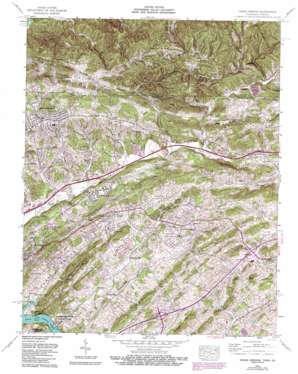
Indian Springs Topo Map Tennessee
To zoom in, hover over the map of Indian Springs
USGS Topo Quad 36082e4 - 1:24,000 scale
| Topo Map Name: | Indian Springs |
| USGS Topo Quad ID: | 36082e4 |
| Print Size: | ca. 21 1/4" wide x 27" high |
| Southeast Coordinates: | 36.5° N latitude / 82.375° W longitude |
| Map Center Coordinates: | 36.5625° N latitude / 82.4375° W longitude |
| U.S. States: | TN, VA |
| Filename: | o36082e4.jpg |
| Download Map JPG Image: | Indian Springs topo map 1:24,000 scale |
| Map Type: | Topographic |
| Topo Series: | 7.5´ |
| Map Scale: | 1:24,000 |
| Source of Map Images: | United States Geological Survey (USGS) |
| Alternate Map Versions: |
Indian Springs TN 1935 Download PDF Buy paper map Indian Springs TN 1939, updated 1954 Download PDF Buy paper map Indian Springs TN 1940 Download PDF Buy paper map Indian Springs TN 1959, updated 1961 Download PDF Buy paper map Indian Springs TN 1959, updated 1970 Download PDF Buy paper map Indian Springs TN 1959, updated 1976 Download PDF Buy paper map Indian Springs TN 1959, updated 1978 Download PDF Buy paper map Indian Springs TN 1959, updated 1992 Download PDF Buy paper map Indian Springs TN 2010 Download PDF Buy paper map Indian Springs TN 2013 Download PDF Buy paper map Indian Springs TN 2016 Download PDF Buy paper map |
1:24,000 Topo Quads surrounding Indian Springs
> Back to 36082e1 at 1:100,000 scale
> Back to 36082a1 at 1:250,000 scale
> Back to U.S. Topo Maps home
Indian Springs topo map: Gazetteer
Indian Springs: Bridges
Anderson Bridge elevation 378m 1240′Hemlock Bridge elevation 385m 1263′
Indian Springs: Cliffs
Moody Bluff elevation 388m 1272′Indian Springs: Crossings
Interchange 63 elevation 501m 1643′Interchange 66 elevation 520m 1706′
Indian Springs: Gaps
Low Gap elevation 621m 2037′Indian Springs: Populated Places
Arcadia elevation 421m 1381′Beechcliff Estates elevation 446m 1463′
Bloomingdale elevation 439m 1440′
Brairwood Acres elevation 471m 1545′
Bridwell Heights elevation 490m 1607′
Edgeworth (historical) elevation 511m 1676′
Fall Creek elevation 472m 1548′
Fox Fire elevation 496m 1627′
Gunnings elevation 510m 1673′
Harrtown elevation 508m 1666′
Hemlock elevation 402m 1318′
Hillcrest elevation 478m 1568′
Hobart Meadows elevation 477m 1564′
Holiday Hills elevation 481m 1578′
Huddle Mill elevation 427m 1400′
Indian Hills elevation 486m 1594′
Ketrontown elevation 441m 1446′
Kingsley Hills elevation 421m 1381′
Lake Park elevation 447m 1466′
Lawson (historical) elevation 476m 1561′
Mystic Valley elevation 477m 1564′
Orebank elevation 424m 1391′
Pettyjohn Mill elevation 442m 1450′
Preston Woods elevation 447m 1466′
Rock City elevation 470m 1541′
Scenic Woods elevation 468m 1535′
Silvacola elevation 433m 1420′
Sunnyside elevation 479m 1571′
Sunrise Valley elevation 522m 1712′
Thomas Heights elevation 551m 1807′
Woodrow elevation 440m 1443′
Indian Springs: Ridges
Baker Ridge elevation 540m 1771′Chestnut Ridge elevation 529m 1735′
Coleman Ridge elevation 461m 1512′
Gate Ridge elevation 624m 2047′
Hooper Ridge elevation 533m 1748′
Hunt Ridge elevation 474m 1555′
Lower Cave Ridge elevation 608m 1994′
Mill Ridge elevation 578m 1896′
Mullins Ridge elevation 655m 2148′
Indian Springs: Springs
Big Spring elevation 415m 1361′Indian Springs: Streams
Boozy Creek elevation 388m 1272′Boozy Creek elevation 388m 1272′
Cedar Branch elevation 404m 1325′
Clark Branch elevation 369m 1210′
Cold Springs Branch elevation 427m 1400′
Cole Branch elevation 406m 1332′
Cooks Valley Branch elevation 386m 1266′
Gaines Branch elevation 377m 1236′
Gardner Branch elevation 390m 1279′
Hicks Branch elevation 381m 1250′
Indian Creek elevation 442m 1450′
Peaveler Branch elevation 373m 1223′
Rocky Branch elevation 426m 1397′
Sinking Water Branch elevation 425m 1394′
Sougan Branch elevation 448m 1469′
Timbertree Branch elevation 384m 1259′
Timbertree Branch elevation 384m 1259′
Venus Branch elevation 376m 1233′
Indian Springs: Summits
Browder Mountain elevation 596m 1955′Indian Springs: Valleys
Boyd Hollow elevation 447m 1466′Bright Hollow elevation 415m 1361′
Browder Hollow elevation 489m 1604′
Cole Hollow elevation 407m 1335′
Cook Valley elevation 386m 1266′
Dungeon Hollow elevation 495m 1624′
Harkleroad Hollow elevation 473m 1551′
Hensley Hollow elevation 509m 1669′
Hooven Hollow elevation 390m 1279′
Jackson Hollow elevation 449m 1473′
Mollie Hollow elevation 389m 1276′
Muddy Spring Hollow elevation 477m 1564′
Mullins Hollow elevation 504m 1653′
Newhouse Hollow elevation 473m 1551′
Poor Hollow elevation 402m 1318′
Sougan Hollow elevation 448m 1469′
Spicewood Hollow elevation 505m 1656′
Sugar Hollow elevation 473m 1551′
Indian Springs digital topo map on disk
Buy this Indian Springs topo map showing relief, roads, GPS coordinates and other geographical features, as a high-resolution digital map file on DVD:
Western Virginia & Southern West Virginia
Buy digital topo maps: Western Virginia & Southern West Virginia


