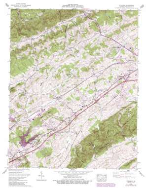
Wyndale Topo Map Virginia
To zoom in, hover over the map of Wyndale
USGS Topo Quad 36082f1 - 1:24,000 scale
| Topo Map Name: | Wyndale |
| USGS Topo Quad ID: | 36082f1 |
| Print Size: | ca. 21 1/4" wide x 27" high |
| Southeast Coordinates: | 36.625° N latitude / 82° W longitude |
| Map Center Coordinates: | 36.6875° N latitude / 82.0625° W longitude |
| U.S. State: | VA |
| Filename: | o36082f1.jpg |
| Download Map JPG Image: | Wyndale topo map 1:24,000 scale |
| Map Type: | Topographic |
| Topo Series: | 7.5´ |
| Map Scale: | 1:24,000 |
| Source of Map Images: | United States Geological Survey (USGS) |
| Alternate Map Versions: |
Wyndale VA 1934 Download PDF Buy paper map Wyndale VA 1938 Download PDF Buy paper map Wyndale VA 1938 Download PDF Buy paper map Wyndale VA 1938, updated 1957 Download PDF Buy paper map Wyndale VA 1960, updated 1962 Download PDF Buy paper map Wyndale VA 1960, updated 1962 Download PDF Buy paper map Wyndale VA 1960, updated 1970 Download PDF Buy paper map Wyndale VA 1960, updated 1978 Download PDF Buy paper map Wyndale VA 1960, updated 1993 Download PDF Buy paper map Wyndale VA 2010 Download PDF Buy paper map Wyndale VA 2013 Download PDF Buy paper map Wyndale VA 2016 Download PDF Buy paper map |
1:24,000 Topo Quads surrounding Wyndale
> Back to 36082e1 at 1:100,000 scale
> Back to 36082a1 at 1:250,000 scale
> Back to U.S. Topo Maps home
Wyndale topo map: Gazetteer
Wyndale: Airports
Ingersoll-Rand Bristol Heliport elevation 559m 1833′Virginia Highlands Airport elevation 628m 2060′
Wyndale: Basins
Hall Bottom elevation 585m 1919′Wyndale: Bridges
Colonel Robert Preston Memorial Bridge elevation 546m 1791′Wyndale: Crossings
Interchange 10 elevation 602m 1975′Interchange 13 elevation 603m 1978′
Interchange 14 elevation 646m 2119′
Interchange 7 elevation 552m 1811′
Wyndale: Dams
Beaver Creek Dam elevation 555m 1820′Clear Creek Dam elevation 585m 1919′
Wyndale: Populated Places
Butts elevation 615m 2017′Colonial Heights elevation 546m 1791′
Cummings Heights elevation 634m 2080′
Evergreen Hills elevation 616m 2020′
Fractionville elevation 640m 2099′
Greendale elevation 585m 1919′
Hilander Park elevation 614m 2014′
Hossan Heights elevation 569m 1866′
Preston Hills elevation 569m 1866′
Rust Hollow elevation 626m 2053′
Shadow Valley elevation 571m 1873′
Withers elevation 573m 1879′
Wyndale elevation 609m 1998′
Wyndale: Reservoirs
Beaver Creek Impoundment elevation 574m 1883′Beaver Creek Lake elevation 555m 1820′
Clear Creek Lake elevation 585m 1919′
Wyndale: Ridges
Countiss Ridge elevation 730m 2395′King Ridge elevation 686m 2250′
Wyndale: Springs
Big Spring elevation 585m 1919′Preston Spring elevation 568m 1863′
Roaring Spring elevation 648m 2125′
Wyndale: Streams
Clear Creek elevation 546m 1791′Lick Branch elevation 550m 1804′
Little Creek elevation 477m 1564′
Roaring Spring Branch elevation 572m 1876′
Wyndale: Summits
Puckett Knob elevation 701m 2299′Ratcliff Knob elevation 744m 2440′
Willoughby Hill elevation 654m 2145′
Wyndale: Valleys
Black Hollow elevation 586m 1922′Childers Hollow elevation 604m 1981′
Cole Hollow elevation 592m 1942′
Negro Hollow elevation 543m 1781′
Rye Hollow elevation 546m 1791′
Spoon Gap Hollow elevation 568m 1863′
Stillhouse Hollow elevation 548m 1797′
Wyndale digital topo map on disk
Buy this Wyndale topo map showing relief, roads, GPS coordinates and other geographical features, as a high-resolution digital map file on DVD:
Western Virginia & Southern West Virginia
Buy digital topo maps: Western Virginia & Southern West Virginia


