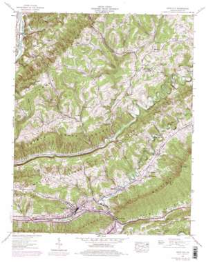
Gate City Topo Map Virginia
To zoom in, hover over the map of Gate City
USGS Topo Quad 36082f5 - 1:24,000 scale
| Topo Map Name: | Gate City |
| USGS Topo Quad ID: | 36082f5 |
| Print Size: | ca. 21 1/4" wide x 27" high |
| Southeast Coordinates: | 36.625° N latitude / 82.5° W longitude |
| Map Center Coordinates: | 36.6875° N latitude / 82.5625° W longitude |
| U.S. State: | VA |
| Filename: | o36082f5.jpg |
| Download Map JPG Image: | Gate City topo map 1:24,000 scale |
| Map Type: | Topographic |
| Topo Series: | 7.5´ |
| Map Scale: | 1:24,000 |
| Source of Map Images: | United States Geological Survey (USGS) |
| Alternate Map Versions: |
Gate City VA 1935 Download PDF Buy paper map Gate City VA 1938, updated 1960 Download PDF Buy paper map Gate City VA 1938, updated 1965 Download PDF Buy paper map Gate City VA 1938, updated 1970 Download PDF Buy paper map Gate City VA 1938, updated 1978 Download PDF Buy paper map Gate City VA 1938, updated 1978 Download PDF Buy paper map Gate City VA 1939 Download PDF Buy paper map Gate City VA 2010 Download PDF Buy paper map Gate City VA 2013 Download PDF Buy paper map Gate City VA 2016 Download PDF Buy paper map |
1:24,000 Topo Quads surrounding Gate City
> Back to 36082e1 at 1:100,000 scale
> Back to 36082a1 at 1:250,000 scale
> Back to U.S. Topo Maps home
Gate City topo map: Gazetteer
Gate City: Basins
Little Poor Valley elevation 411m 1348′Gate City: Cliffs
Copper Creek Bluff elevation 427m 1400′Gate City: Lakes
Blue Water Pond elevation 603m 1978′Gate City: Parks
R P Kane Athletic Field elevation 414m 1358′Gate City: Populated Places
Carrico Mill elevation 588m 1929′Cox Mill elevation 463m 1519′
Gate City elevation 408m 1338′
Jayne Mill elevation 389m 1276′
Marcem elevation 447m 1466′
Nottingham elevation 437m 1433′
Slabtown elevation 391m 1282′
Williams Mill elevation 504m 1653′
Gate City: Post Offices
Gate City Post Office elevation 404m 1325′Slant Post Office elevation 399m 1309′
Weber City Post Office elevation 396m 1299′
Gate City: Springs
Big Spring elevation 508m 1666′Buck Spring elevation 506m 1660′
Hale Spring elevation 468m 1535′
Quillin Spring elevation 452m 1482′
Gate City: Streams
Burnt Cabin Branch elevation 396m 1299′Chapman Branch elevation 430m 1410′
Cove Creek elevation 377m 1236′
Flower Branch elevation 390m 1279′
Franklin Branch elevation 390m 1279′
Gillenwater Branch elevation 532m 1745′
Lark Creek elevation 386m 1266′
Little Moccasin Creek elevation 375m 1230′
McDowell Branch elevation 378m 1240′
Obeys Creek elevation 398m 1305′
Peters Branch elevation 533m 1748′
Pike elevation 394m 1292′
Pine Branch elevation 542m 1778′
Plank Camp Creek elevation 393m 1289′
Red Hill Branch elevation 381m 1250′
Strong Branch elevation 530m 1738′
Valley Creek elevation 431m 1414′
Widow Branch elevation 376m 1233′
Gate City: Summits
Big Knob elevation 919m 3015′Gate City: Valleys
Alley Valley elevation 403m 1322′Davidson Hollow elevation 521m 1709′
Dry Hollow elevation 585m 1919′
Gilmore Hollow elevation 517m 1696′
Moccasin Valley elevation 397m 1302′
Newton Hollow elevation 430m 1410′
Peters Hollow elevation 451m 1479′
Williams Hollow elevation 406m 1332′
Gate City digital topo map on disk
Buy this Gate City topo map showing relief, roads, GPS coordinates and other geographical features, as a high-resolution digital map file on DVD:
Western Virginia & Southern West Virginia
Buy digital topo maps: Western Virginia & Southern West Virginia


