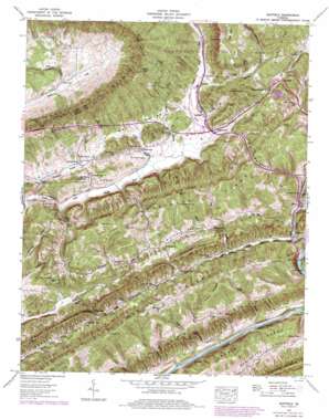
Duffield Topo Map Virginia
To zoom in, hover over the map of Duffield
USGS Topo Quad 36082f7 - 1:24,000 scale
| Topo Map Name: | Duffield |
| USGS Topo Quad ID: | 36082f7 |
| Print Size: | ca. 21 1/4" wide x 27" high |
| Southeast Coordinates: | 36.625° N latitude / 82.75° W longitude |
| Map Center Coordinates: | 36.6875° N latitude / 82.8125° W longitude |
| U.S. State: | VA |
| Filename: | o36082f7.jpg |
| Download Map JPG Image: | Duffield topo map 1:24,000 scale |
| Map Type: | Topographic |
| Topo Series: | 7.5´ |
| Map Scale: | 1:24,000 |
| Source of Map Images: | United States Geological Survey (USGS) |
| Alternate Map Versions: |
Duffield VA 1935 Download PDF Buy paper map Duffield VA 1947, updated 1963 Download PDF Buy paper map Duffield VA 1947, updated 1967 Download PDF Buy paper map Duffield VA 1947, updated 1970 Download PDF Buy paper map Duffield VA 1947, updated 1978 Download PDF Buy paper map Duffield VA 1950 Download PDF Buy paper map Duffield VA 1950 Download PDF Buy paper map Duffield VA 1976, updated 1981 Download PDF Buy paper map Duffield VA 2011 Download PDF Buy paper map Duffield VA 2013 Download PDF Buy paper map Duffield VA 2016 Download PDF Buy paper map |
| FStopo: | US Forest Service topo Duffield is available: Download FStopo PDF Download FStopo TIF |
1:24,000 Topo Quads surrounding Duffield
> Back to 36082e1 at 1:100,000 scale
> Back to 36082a1 at 1:250,000 scale
> Back to U.S. Topo Maps home
Duffield topo map: Gazetteer
Duffield: Airports
DDA Heliport elevation 402m 1318′Duffield: Basins
Back Valley elevation 425m 1394′Dry Hollow elevation 460m 1509′
Purchase Valley elevation 466m 1528′
Robinette Valley elevation 474m 1555′
Speers Valley elevation 430m 1410′
Duffield: Crossings
Powers Ford elevation 388m 1272′Duffield: Gaps
Devils Racepath elevation 536m 1758′Drakes Gap elevation 401m 1315′
Kane Gap elevation 785m 2575′
Duffield: Populated Places
Duffield elevation 438m 1437′Fraleytown elevation 401m 1315′
Glenita elevation 395m 1295′
Natural Tunnel elevation 435m 1427′
Pattonsville elevation 406m 1332′
Peterson elevation 425m 1394′
Sloantown elevation 412m 1351′
Sunbright elevation 470m 1541′
Duffield: Post Offices
Hortons Summit Post Office elevation 468m 1535′Duffield: Ranges
River Knobs elevation 441m 1446′Duffield: Ridges
Big Ridge elevation 554m 1817′Big Ridge elevation 554m 1817′
Colt Ridge elevation 608m 1994′
Pine Ridge elevation 469m 1538′
Pine Ridge elevation 556m 1824′
Purchase Ridge elevation 574m 1883′
Stone Ridge elevation 595m 1952′
Duffield: Streams
Bobs Branch elevation 365m 1197′Drakes Branch elevation 364m 1194′
Dry Branch elevation 418m 1371′
Dry Creek elevation 385m 1263′
Falin Branch elevation 365m 1197′
Falin Branch elevation 365m 1197′
Ford Branch elevation 402m 1318′
Fraley Branch elevation 394m 1292′
Harris Branch elevation 395m 1295′
Horton Branch elevation 388m 1272′
Irving Branch elevation 366m 1200′
Little Stock Creek elevation 371m 1217′
Pattonsville Branch elevation 390m 1279′
Rogers Branch elevation 392m 1286′
Scotts Branch elevation 511m 1676′
Spurlock Branch elevation 409m 1341′
Troublesome Creek elevation 369m 1210′
Watts Branch elevation 365m 1197′
Duffield: Summits
Purchase Knob elevation 633m 2076′Sols Knob elevation 558m 1830′
Duffield: Tunnels
Bald Knob Tunnel elevation 440m 1443′Duffield: Valleys
Ford Valley elevation 378m 1240′Hunter Valley elevation 469m 1538′
Duffield digital topo map on disk
Buy this Duffield topo map showing relief, roads, GPS coordinates and other geographical features, as a high-resolution digital map file on DVD:
Western Virginia & Southern West Virginia
Buy digital topo maps: Western Virginia & Southern West Virginia


