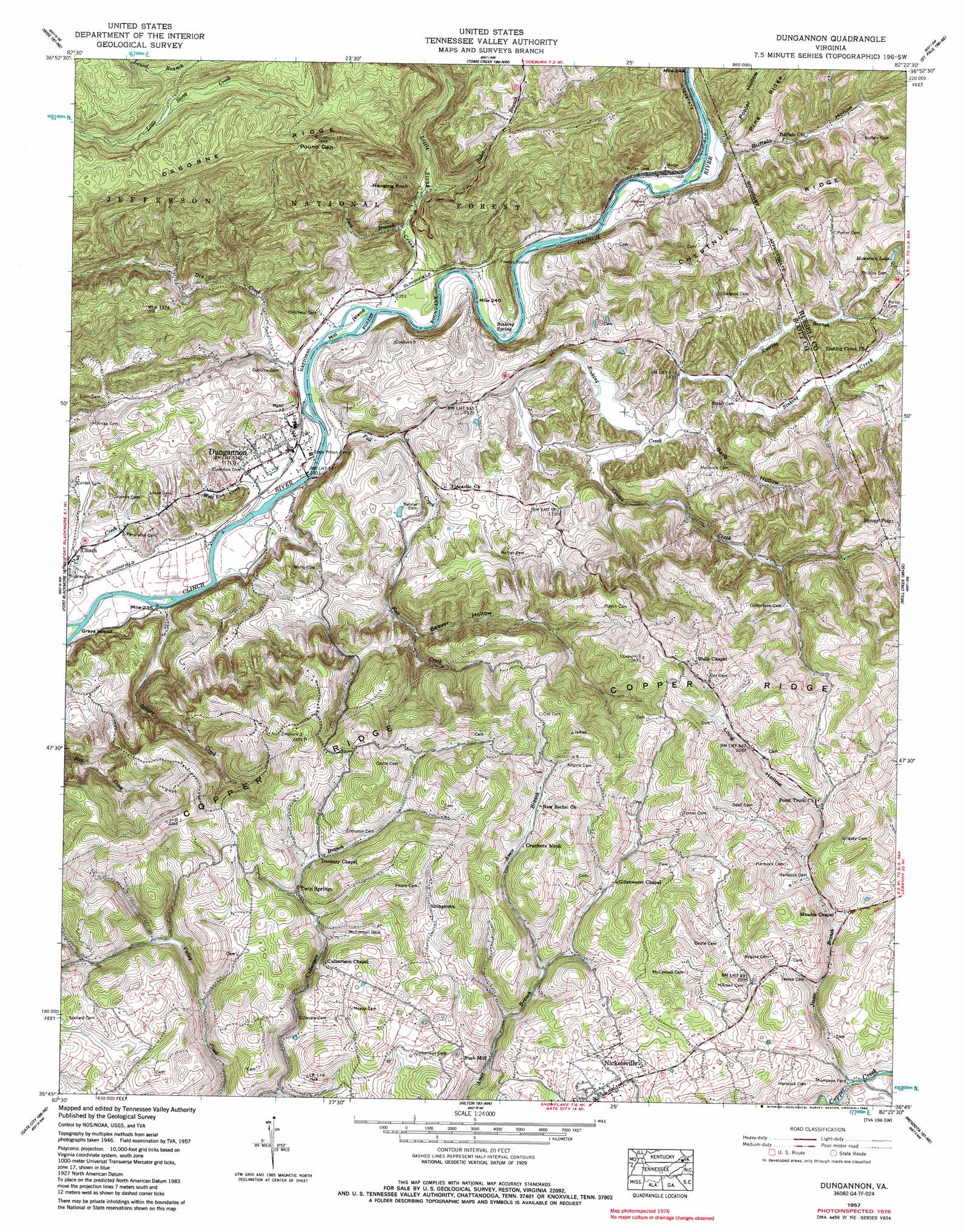
Dungannon Topo Map Virginia
To zoom in, hover over the map of Dungannon
USGS Topo Quad 36082g4 - 1:24,000 scale
| Topo Map Name: | Dungannon |
| USGS Topo Quad ID: | 36082g4 |
| Print Size: | ca. 21 1/4" wide x 27" high |
| Southeast Coordinates: | 36.75° N latitude / 82.375° W longitude |
| Map Center Coordinates: | 36.8125° N latitude / 82.4375° W longitude |
| U.S. State: | VA |
| Filename: | o36082g4.jpg |
| Download Map JPG Image: | Dungannon topo map 1:24,000 scale |
| Map Type: | Topographic |
| Topo Series: | 7.5´ |
| Map Scale: | 1:24,000 |
| Source of Map Images: | United States Geological Survey (USGS) |
| Alternate Map Versions: |
Dungannon VA 1935 Download PDF Buy paper map Dungannon VA 1957, updated 1960 Download PDF Buy paper map Dungannon VA 1957, updated 1960 Download PDF Buy paper map Dungannon VA 1957, updated 1986 Download PDF Buy paper map Dungannon VA 2011 Download PDF Buy paper map Dungannon VA 2013 Download PDF Buy paper map Dungannon VA 2016 Download PDF Buy paper map |
| FStopo: | US Forest Service topo Dungannon is available: Download FStopo PDF Download FStopo TIF |
1:24,000 Topo Quads surrounding Dungannon
Flat Gap |
Pound |
Caney Ridge |
Nora |
Duty |
Norton |
Wise |
Coeburn |
Saint Paul |
Carbo |
East Stone Gap |
Fort Blackmore |
Dungannon |
Moll Creek |
Hansonville |
Clinchport |
Gate City |
Hilton |
Mendota |
Wallace |
Church Hill |
Kingsport |
Indian Springs |
Blountville |
Bristol |
> Back to 36082e1 at 1:100,000 scale
> Back to 36082a1 at 1:250,000 scale
> Back to U.S. Topo Maps home
Dungannon topo map: Gazetteer
Dungannon: Crossings
Thompson Ford elevation 521m 1709′Dungannon: Gaps
Pound Gap elevation 773m 2536′Dungannon: Islands
Mill Island elevation 399m 1309′Dungannon: Pillars
Hanging Rock elevation 607m 1991′Dungannon: Populated Places
Bush Mill elevation 546m 1791′Clinch elevation 393m 1289′
Crackers Neck elevation 626m 2053′
Dungannon elevation 408m 1338′
Grigbys Store elevation 607m 1991′
Nickelsville elevation 584m 1916′
Stony elevation 410m 1345′
Stringtown elevation 631m 2070′
Sunny Point elevation 633m 2076′
Twin Springs elevation 584m 1916′
Dungannon: Reservoirs
Mountain Lake elevation 467m 1532′Dungannon: Ridges
Chesnut Ridge elevation 652m 2139′Osborne Ridge elevation 775m 2542′
Dungannon: Springs
Sinking Spring elevation 407m 1335′Dungannon: Streams
Baker Branch elevation 445m 1459′Benges Creek elevation 390m 1279′
Big Spring Branch elevation 606m 1988′
Cowan Creek elevation 430m 1410′
Dry Creek elevation 398m 1305′
Fall Creek elevation 394m 1292′
Jack Branch elevation 428m 1404′
Jessee Branch elevation 523m 1715′
Little Stony Creek elevation 400m 1312′
Roaring Branch elevation 437m 1433′
Sinking Creek elevation 457m 1499′
Wolf Run Creek elevation 395m 1295′
Dungannon: Summits
Bald Rock elevation 655m 2148′Dungannon: Tunnels
Townes Tunnel elevation 472m 1548′Dungannon: Valleys
Barb Hollow elevation 436m 1430′Beaver Hollow elevation 477m 1564′
Buffalo Hollow elevation 430m 1410′
Long Hollow elevation 607m 1991′
Muttonhead Hollow elevation 606m 1988′
Poplar Hollow elevation 426m 1397′
Dungannon digital topo map on disk
Buy this Dungannon topo map showing relief, roads, GPS coordinates and other geographical features, as a high-resolution digital map file on DVD:
Western Virginia & Southern West Virginia
Buy digital topo maps: Western Virginia & Southern West Virginia