Fort Blackmore Topo Map Virginia
To zoom in, hover over the map of Fort Blackmore
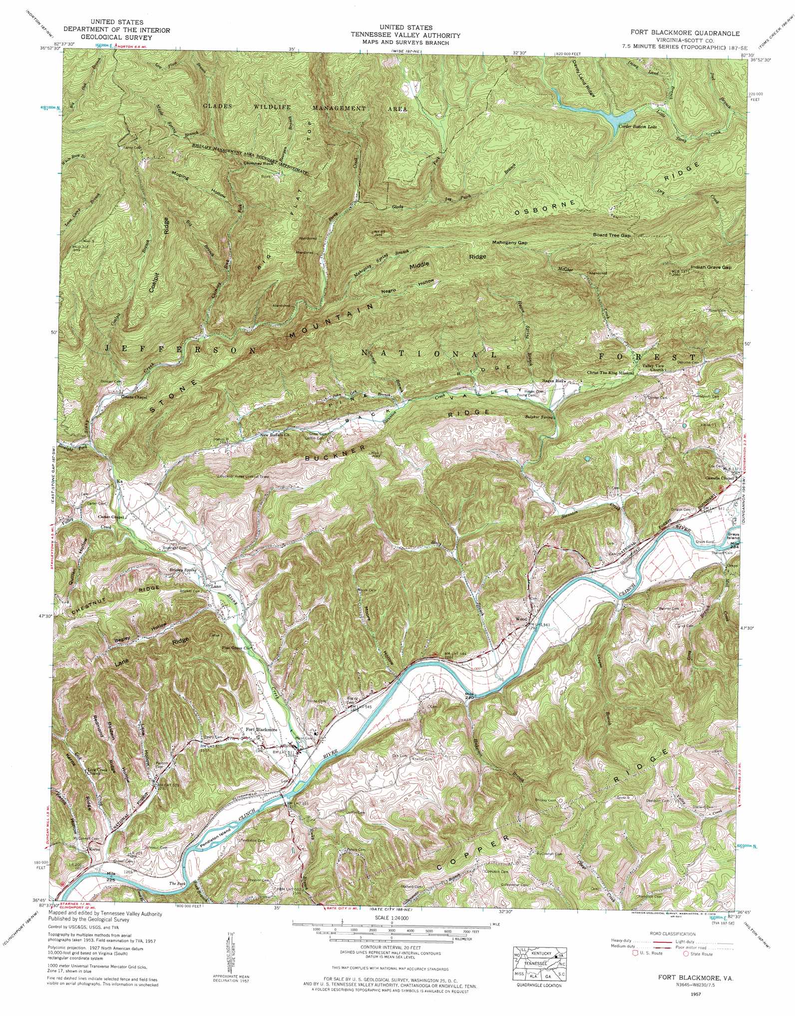
USGS Topo Quad 36082g5 - 1:24,000 scale
| Topo Map Name: | Fort Blackmore |
| USGS Topo Quad ID: | 36082g5 |
| Print Size: | ca. 21 1/4" wide x 27" high |
| Southeast Coordinates: | 36.75° N latitude / 82.5° W longitude |
| Map Center Coordinates: | 36.8125° N latitude / 82.5625° W longitude |
| U.S. State: | VA |
| Filename: | o36082g5.jpg |
| Download Map JPG Image: | Fort Blackmore topo map 1:24,000 scale |
| Map Type: | Topographic |
| Topo Series: | 7.5´ |
| Map Scale: | 1:24,000 |
| Source of Map Images: | United States Geological Survey (USGS) |
| Alternate Map Versions: |
Fort Blackmore VA 1935 Download PDF Buy paper map Fort Blackmore VA 1957, updated 1959 Download PDF Buy paper map Fort Blackmore VA 1957, updated 1959 Download PDF Buy paper map Fort Blackmore VA 2011 Download PDF Buy paper map Fort Blackmore VA 2013 Download PDF Buy paper map Fort Blackmore VA 2016 Download PDF Buy paper map |
| FStopo: | US Forest Service topo Fort Blackmore is available: Download FStopo PDF Download FStopo TIF |
1:24,000 Topo Quads surrounding Fort Blackmore
Whitesburg |
Flat Gap |
Pound |
Caney Ridge |
Nora |
Appalachia |
Norton |
Wise |
Coeburn |
Saint Paul |
Big Stone Gap |
East Stone Gap |
Fort Blackmore |
Dungannon |
Moll Creek |
Duffield |
Clinchport |
Gate City |
Hilton |
Mendota |
Plum Grove |
Church Hill |
Kingsport |
Indian Springs |
Blountville |
> Back to 36082e1 at 1:100,000 scale
> Back to 36082a1 at 1:250,000 scale
> Back to U.S. Topo Maps home
Fort Blackmore topo map: Gazetteer
Fort Blackmore: Bends
The Suck elevation 377m 1236′Fort Blackmore: Bridges
Glenn Carter Memorial Bridge elevation 446m 1463′Fort Blackmore: Dams
Bark Camp Dam elevation 832m 2729′Fort Blackmore: Gaps
Board Tree Gap elevation 818m 2683′Indian Grave Gap elevation 742m 2434′
Mahogany Gap elevation 840m 2755′
Fort Blackmore: Islands
Grays Island elevation 387m 1269′Pendleton Island elevation 378m 1240′
Fort Blackmore: Populated Places
Fort Blackmore elevation 400m 1312′Grays elevation 400m 1312′
Grays Ford elevation 386m 1266′
Kerns elevation 385m 1263′
Lano elevation 414m 1358′
Valaho (historical) elevation 462m 1515′
Wood elevation 395m 1295′
Fort Blackmore: Reservoirs
Bark Camp Lake elevation 832m 2729′Fort Blackmore: Ridges
Buckner Ridge elevation 577m 1893′Chestnut Ridge elevation 550m 1804′
Coalpit Ridge elevation 942m 3090′
Kerns Ridge elevation 495m 1624′
Lane Ridge elevation 581m 1906′
Middle Ridge elevation 849m 2785′
Osborne Ridge elevation 897m 2942′
Pine Ridge elevation 473m 1551′
Redmond Ridge elevation 455m 1492′
Fort Blackmore: Springs
Brickey Spring elevation 416m 1364′Sulphur Spring elevation 406m 1332′
Fort Blackmore: Streams
Bearpen Branch elevation 762m 2500′Big Branch elevation 571m 1873′
Chimney Rock Fork elevation 517m 1696′
Coalpit Branch elevation 481m 1578′
Cornett Branch elevation 428m 1404′
Cub Creek elevation 387m 1269′
Davey Land Branch elevation 828m 2716′
Dingus Branch elevation 385m 1263′
Ford Branch elevation 376m 1233′
Glady Fork elevation 647m 2122′
Gray Branch elevation 414m 1358′
Hagan Spring Branch elevation 410m 1345′
Hickerson Branch elevation 384m 1259′
Ivy Patch Branch elevation 736m 2414′
Joel Branch elevation 779m 2555′
John Gay Branch elevation 431m 1414′
Lick Creek elevation 377m 1236′
Low Place Branch elevation 844m 2769′
Mahogany Spring Branch elevation 590m 1935′
Maple Spring Branch elevation 778m 2552′
McGhee Creek elevation 407m 1335′
Mill Creek elevation 389m 1276′
Rocky Branch elevation 383m 1256′
Stacy Branch elevation 383m 1256′
Staunton Creek elevation 383m 1256′
Stony Creek elevation 380m 1246′
Straight Fork elevation 461m 1512′
Suck Branch elevation 390m 1279′
Valley Creek elevation 425m 1394′
Fort Blackmore: Summits
Big Flat Top elevation 897m 2942′Chimney Rock elevation 778m 2552′
Fort Blackmore: Valleys
Back Valley elevation 408m 1338′Baldwin Hollow elevation 384m 1259′
Begley Hollow elevation 413m 1354′
Kerns Hollow elevation 387m 1269′
Lane Hollow elevation 388m 1272′
Moore Hollow elevation 383m 1256′
Moping Hollow elevation 633m 2076′
Negro Hollow elevation 590m 1935′
Quillen Hollow elevation 438m 1437′
Fort Blackmore digital topo map on disk
Buy this Fort Blackmore topo map showing relief, roads, GPS coordinates and other geographical features, as a high-resolution digital map file on DVD:
Western Virginia & Southern West Virginia
Buy digital topo maps: Western Virginia & Southern West Virginia