East Stone Gap Topo Map Virginia
To zoom in, hover over the map of East Stone Gap
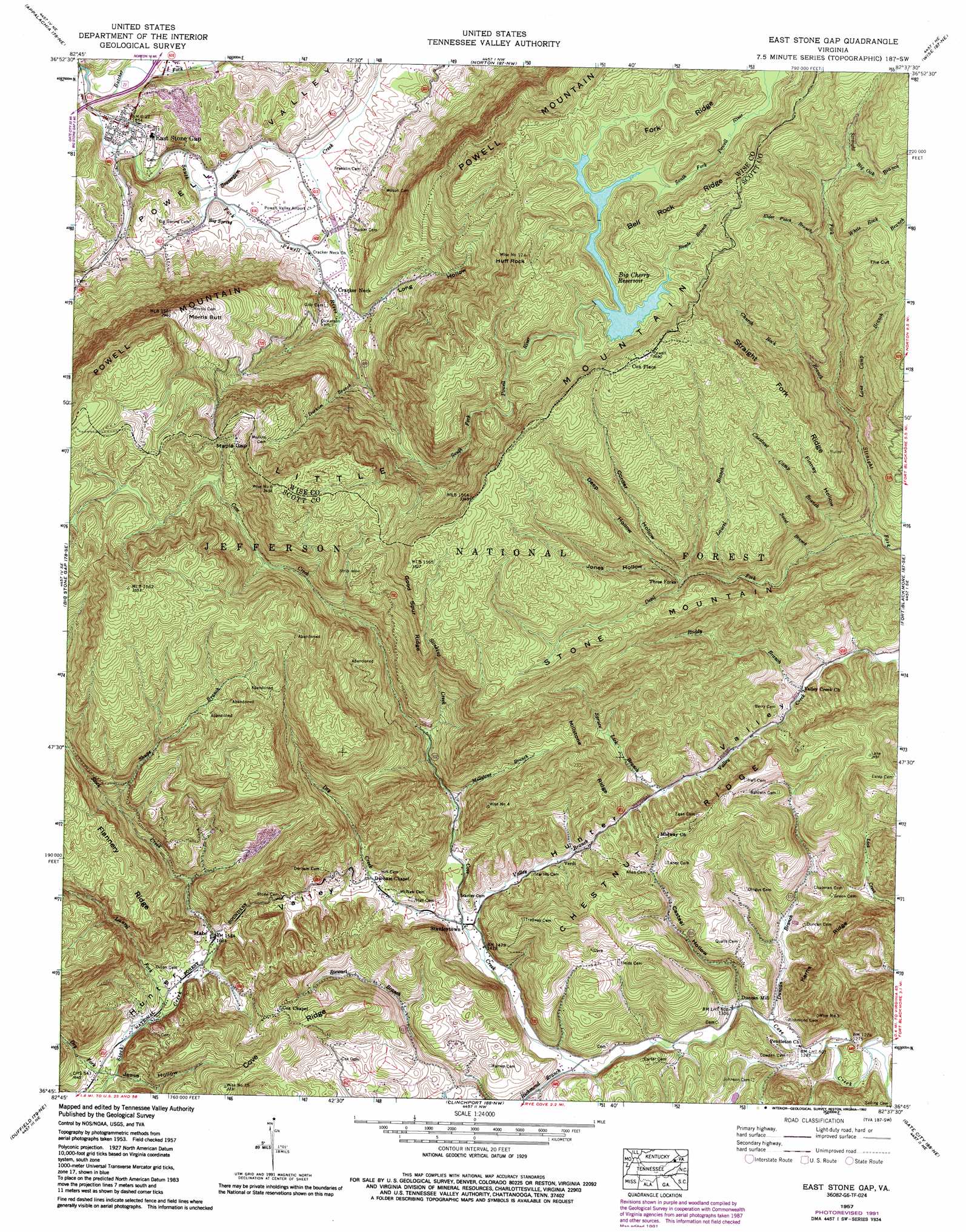
USGS Topo Quad 36082g6 - 1:24,000 scale
| Topo Map Name: | East Stone Gap |
| USGS Topo Quad ID: | 36082g6 |
| Print Size: | ca. 21 1/4" wide x 27" high |
| Southeast Coordinates: | 36.75° N latitude / 82.625° W longitude |
| Map Center Coordinates: | 36.8125° N latitude / 82.6875° W longitude |
| U.S. State: | VA |
| Filename: | o36082g6.jpg |
| Download Map JPG Image: | East Stone Gap topo map 1:24,000 scale |
| Map Type: | Topographic |
| Topo Series: | 7.5´ |
| Map Scale: | 1:24,000 |
| Source of Map Images: | United States Geological Survey (USGS) |
| Alternate Map Versions: |
East Stone Gap VA 1935 Download PDF Buy paper map East Stone Gap VA 1957, updated 1959 Download PDF Buy paper map East Stone Gap VA 1957, updated 1970 Download PDF Buy paper map East Stone Gap VA 1957, updated 1978 Download PDF Buy paper map East Stone Gap VA 1957, updated 1992 Download PDF Buy paper map East Stone Gap VA 2011 Download PDF Buy paper map East Stone Gap VA 2013 Download PDF Buy paper map East Stone Gap VA 2016 Download PDF Buy paper map |
| FStopo: | US Forest Service topo East Stone Gap is available: Download FStopo PDF Download FStopo TIF |
1:24,000 Topo Quads surrounding East Stone Gap
Roxana |
Whitesburg |
Flat Gap |
Pound |
Caney Ridge |
Benham |
Appalachia |
Norton |
Wise |
Coeburn |
Keokee |
Big Stone Gap |
East Stone Gap |
Fort Blackmore |
Dungannon |
Stickleyville |
Duffield |
Clinchport |
Gate City |
Hilton |
Looneys Gap |
Plum Grove |
Church Hill |
Kingsport |
Indian Springs |
> Back to 36082e1 at 1:100,000 scale
> Back to 36082a1 at 1:250,000 scale
> Back to U.S. Topo Maps home
East Stone Gap topo map: Gazetteer
East Stone Gap: Airports
Powell Valley Airport elevation 486m 1594′East Stone Gap: Dams
Big Cherry Dam elevation 953m 3126′East Stone Gap: Gaps
Cracker Neck elevation 687m 2253′Maple Gap elevation 946m 3103′
The Cut elevation 896m 2939′
East Stone Gap: Populated Places
Cox Place elevation 1056m 3464′Cracker Neck elevation 512m 1679′
Duncan Mill elevation 414m 1358′
East Stone Gap elevation 469m 1538′
Mintons Store elevation 494m 1620′
Riggs (historical) elevation 400m 1312′
Stanleytown elevation 457m 1499′
Three Forks elevation 673m 2208′
Verdi elevation 522m 1712′
East Stone Gap: Reservoirs
Big Cherry Reservoir elevation 953m 3126′East Stone Gap: Ridges
Bell Rock Ridge elevation 1051m 3448′Chestnut Ridge elevation 575m 1886′
Fork Ridge elevation 1004m 3293′
Good Spur Ridge elevation 981m 3218′
Millstone Ridge elevation 659m 2162′
Straight Fork Ridge elevation 831m 2726′
East Stone Gap: Springs
Big Spring elevation 482m 1581′East Stone Gap: Streams
Beaverdam Creek elevation 477m 1564′Big Oak Branch elevation 864m 2834′
Butcher Fork elevation 458m 1502′
Chestnut Camp Branch elevation 506m 1660′
Church Rock Branch elevation 569m 1866′
Devil Fork elevation 617m 2024′
Dry Creek elevation 452m 1482′
Dry Fork elevation 453m 1486′
Duncan Branch elevation 392m 1286′
Durham Branch elevation 558m 1830′
Elder Patch Branch elevation 785m 2575′
Lane Camp Branch elevation 569m 1866′
Laurel Branch elevation 640m 2099′
Laurel Fork elevation 487m 1597′
Millstone Branch elevation 503m 1650′
Richmond Branch elevation 413m 1354′
Roads Branch elevation 956m 3136′
Roddy Branch elevation 472m 1548′
Saint Branch elevation 530m 1738′
Shupe Branch elevation 639m 2096′
Spruce Lick Branch elevation 481m 1578′
Stewart Branch elevation 484m 1587′
Stinking Creek elevation 545m 1788′
Valley Creek elevation 448m 1469′
White Rock Branch elevation 775m 2542′
Wildcat Creek elevation 461m 1512′
East Stone Gap: Summits
Huff Rock elevation 1070m 3510′Little Mountain elevation 883m 2896′
Morris Butt elevation 822m 2696′
East Stone Gap: Valleys
Casteel Hollow elevation 398m 1305′Corder Hollow elevation 646m 2119′
Deep Hollow elevation 653m 2142′
Finney Hollow elevation 591m 1938′
Jesse Hollow elevation 456m 1496′
Jones Hollow elevation 691m 2267′
Long Hollow elevation 518m 1699′
Powell Valley elevation 458m 1502′
East Stone Gap digital topo map on disk
Buy this East Stone Gap topo map showing relief, roads, GPS coordinates and other geographical features, as a high-resolution digital map file on DVD:
Western Virginia & Southern West Virginia
Buy digital topo maps: Western Virginia & Southern West Virginia