Saint Paul Topo Map Virginia
To zoom in, hover over the map of Saint Paul
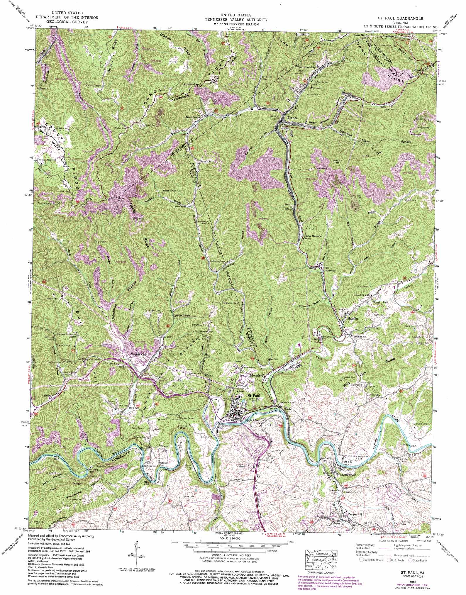
USGS Topo Quad 36082h3 - 1:24,000 scale
| Topo Map Name: | Saint Paul |
| USGS Topo Quad ID: | 36082h3 |
| Print Size: | ca. 21 1/4" wide x 27" high |
| Southeast Coordinates: | 36.875° N latitude / 82.25° W longitude |
| Map Center Coordinates: | 36.9375° N latitude / 82.3125° W longitude |
| U.S. State: | VA |
| Filename: | o36082h3.jpg |
| Download Map JPG Image: | Saint Paul topo map 1:24,000 scale |
| Map Type: | Topographic |
| Topo Series: | 7.5´ |
| Map Scale: | 1:24,000 |
| Source of Map Images: | United States Geological Survey (USGS) |
| Alternate Map Versions: |
St Paul VA 1935 Download PDF Buy paper map St Paul VA 1958, updated 1960 Download PDF Buy paper map St Paul VA 1958, updated 1971 Download PDF Buy paper map St Paul VA 1958, updated 1978 Download PDF Buy paper map St Paul VA 1958, updated 1991 Download PDF Buy paper map St Paul VA 1958, updated 1991 Download PDF Buy paper map Saint Paul VA 2011 Download PDF Buy paper map Saint Paul VA 2013 Download PDF Buy paper map Saint Paul VA 2016 Download PDF Buy paper map |
1:24,000 Topo Quads surrounding Saint Paul
Jenkins East |
Clintwood |
Haysi |
Prater |
Vansant |
Pound |
Caney Ridge |
Nora |
Duty |
Big A Mountain |
Wise |
Coeburn |
Saint Paul |
Carbo |
Lebanon |
Fort Blackmore |
Dungannon |
Moll Creek |
Hansonville |
Brumley |
Gate City |
Hilton |
Mendota |
Wallace |
Wyndale |
> Back to 36082e1 at 1:100,000 scale
> Back to 36082a1 at 1:250,000 scale
> Back to U.S. Topo Maps home
Saint Paul topo map: Gazetteer
Saint Paul: Bridges
Charles Bickley Memorial Bridge elevation 445m 1459′Saint Paul: Crossings
Burtons Ford elevation 434m 1423′Saint Paul: Gaps
Austin Gap elevation 749m 2457′Flint Gap elevation 867m 2844′
Low Gap elevation 806m 2644′
Trammel Gap elevation 783m 2568′
Saint Paul: Populated Places
Bickley Mill elevation 500m 1640′Boody elevation 453m 1486′
Burtons Ford elevation 435m 1427′
Castlewood elevation 492m 1614′
Dante elevation 537m 1761′
Dorado elevation 519m 1702′
Dwina elevation 480m 1574′
Hamlin elevation 497m 1630′
Hazel elevation 858m 2814′
John elevation 530m 1738′
Lonesome (historical) elevation 522m 1712′
Morefield elevation 457m 1499′
Rural elevation 645m 2116′
Saint Paul elevation 458m 1502′
Sun elevation 507m 1663′
Temple Hill elevation 510m 1673′
Trammel (historical) elevation 783m 2568′
Virginia City elevation 482m 1581′
West Dante elevation 578m 1896′
Saint Paul: Ridges
Dismal Ridge elevation 816m 2677′Flat Top Ridge elevation 869m 2851′
Nancy Ridge elevation 695m 2280′
Whetstone Ridge elevation 599m 1965′
Saint Paul: Springs
Big Spring elevation 496m 1627′Saint Paul: Streams
Bee Branch elevation 528m 1732′Big Branch elevation 542m 1778′
Big Spring Branch elevation 447m 1466′
Castle Run elevation 438m 1437′
Crooked Branch elevation 486m 1594′
Granny Branch elevation 505m 1656′
Gravel Lick Creek elevation 497m 1630′
Grindstone Branch elevation 502m 1646′
Hamlin Branch elevation 505m 1656′
Honey Branch elevation 461m 1512′
Honeycomb Branch elevation 543m 1781′
Kilgore Creek elevation 605m 1984′
Laurel Branch elevation 549m 1801′
Left Fork Lick Creek elevation 537m 1761′
Lick Creek elevation 444m 1456′
Meade Creek elevation 480m 1574′
Meadows Branch elevation 546m 1791′
Moses Branch elevation 437m 1433′
Right Fork Lick Creek elevation 537m 1761′
Robinette Branch elevation 444m 1456′
Russell Creek elevation 434m 1423′
Russian Branch elevation 446m 1463′
Seven Spring Creek elevation 471m 1545′
Saint Paul: Summits
Bull Hill elevation 611m 2004′Saint Paul: Tunnels
Big Bull Tunnel elevation 601m 1971′Craigen Tunnel elevation 514m 1686′
Holbrook Tunnel elevation 633m 2076′
Little Bull Tunnel elevation 576m 1889′
Sandy Ridge Tunnel elevation 822m 2696′
Shannon Tunnel elevation 496m 1627′
Saint Paul: Valleys
Bear Wallow Hollow elevation 548m 1797′Caledonia Hollow elevation 497m 1630′
Cigarette Hollow elevation 537m 1761′
Curley Hollow elevation 488m 1601′
Dwina Hollow elevation 491m 1610′
Gose Hollow elevation 461m 1512′
Hall Hollow elevation 451m 1479′
Hardy Hollow elevation 463m 1519′
Hasn Hollow elevation 435m 1427′
Kimberland Hollow elevation 454m 1489′
Maize Hollow elevation 505m 1656′
Squirrel Hollow elevation 542m 1778′
Straight Hollow elevation 543m 1781′
Saint Paul digital topo map on disk
Buy this Saint Paul topo map showing relief, roads, GPS coordinates and other geographical features, as a high-resolution digital map file on DVD:
Western Virginia & Southern West Virginia
Buy digital topo maps: Western Virginia & Southern West Virginia