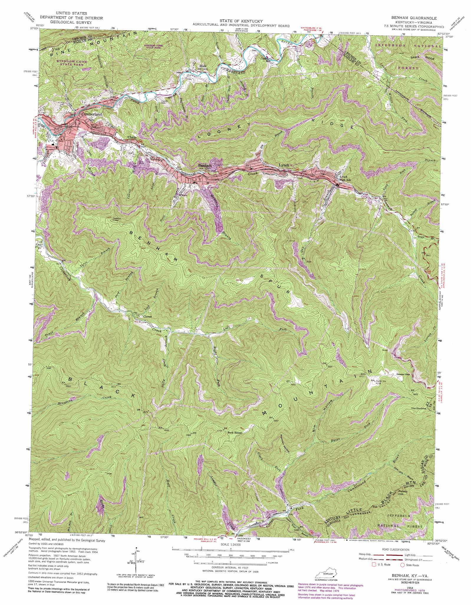
Benham Topo Map Kentucky
To zoom in, hover over the map of Benham
USGS Topo Quad 36082h8 - 1:24,000 scale
| Topo Map Name: | Benham |
| USGS Topo Quad ID: | 36082h8 |
| Print Size: | ca. 21 1/4" wide x 27" high |
| Southeast Coordinates: | 36.875° N latitude / 82.875° W longitude |
| Map Center Coordinates: | 36.9375° N latitude / 82.9375° W longitude |
| U.S. States: | KY, VA |
| Filename: | o36082h8.jpg |
| Download Map JPG Image: | Benham topo map 1:24,000 scale |
| Map Type: | Topographic |
| Topo Series: | 7.5´ |
| Map Scale: | 1:24,000 |
| Source of Map Images: | United States Geological Survey (USGS) |
| Alternate Map Versions: |
Benham KY 1935 Download PDF Buy paper map Benham KY 1954, updated 1956 Download PDF Buy paper map Benham KY 1954, updated 1964 Download PDF Buy paper map Benham KY 1954, updated 1979 Download PDF Buy paper map Benham KY 1954, updated 1990 Download PDF Buy paper map Benham KY 1976, updated 1981 Download PDF Buy paper map Benham KY 2011 Download PDF Buy paper map Benham KY 2013 Download PDF Buy paper map Benham KY 2016 Download PDF Buy paper map |
| FStopo: | US Forest Service topo Benham is available: Download FStopo PDF Download FStopo TIF |
1:24,000 Topo Quads surrounding Benham
Hazard South |
Vicco |
Blackey |
Mayking |
Jenkins West |
Leatherwood |
Tilford |
Roxana |
Whitesburg |
Flat Gap |
Nolansburg |
Louellen |
Benham |
Appalachia |
Norton |
Evarts |
Pennington Gap |
Keokee |
Big Stone Gap |
East Stone Gap |
Hubbard Springs |
Ben Hur |
Stickleyville |
Duffield |
Clinchport |
> Back to 36082e1 at 1:100,000 scale
> Back to 36082a1 at 1:250,000 scale
> Back to U.S. Topo Maps home
Benham topo map: Gazetteer
Benham: Gaps
Deep Gap elevation 981m 3218′Garrison Gap elevation 1098m 3602′
Grassy Gap elevation 1215m 3986′
Low Gap elevation 1022m 3353′
Sugar Gap elevation 1185m 3887′
Benham: Mines
Lynch Tipple Mine (historical) elevation 532m 1745′Portal 30 elevation 541m 1774′
Portal 31 elevation 533m 1748′
Benham: Parks
Coal Miners Memorial Park elevation 486m 1594′Kingdom Come State Park elevation 768m 2519′
Benham: Populated Places
Benham elevation 485m 1591′Blair elevation 449m 1473′
Clover elevation 545m 1788′
Clutts elevation 462m 1515′
Cumberland elevation 440m 1443′
Lynch elevation 523m 1715′
Benham: Post Offices
Benham Post Office elevation 483m 1584′Blair Post Office (historical) elevation 449m 1473′
Clover Post Office (historical) elevation 561m 1840′
Cloverfork Post Office (historical) elevation 632m 2073′
Est Post Office (historical) elevation 456m 1496′
Lynch Post Office elevation 536m 1758′
Pee Vee Post Office (historical) elevation 463m 1519′
Benham: Ridges
Big Ridge elevation 1227m 4025′Divide Ridge elevation 973m 3192′
Looney Ridge elevation 957m 3139′
Middle Ridge elevation 845m 2772′
Rockhouse Ridge elevation 1174m 3851′
Sams Ridge elevation 654m 2145′
Yellow Buck Spur elevation 1160m 3805′
Benham: Streams
Barnett Branch elevation 607m 1991′Beechbottom Branch elevation 445m 1459′
Big Branch elevation 582m 1909′
Big Branch elevation 525m 1722′
Big Cove Branch elevation 446m 1463′
Camp Fork elevation 811m 2660′
Cave Branch elevation 473m 1551′
Charles Branch elevation 573m 1879′
Charlie Blair Branch elevation 448m 1469′
Cherry Fork elevation 809m 2654′
Clark Fork elevation 692m 2270′
Cloverlick Creek elevation 431m 1414′
Coal Bank Branch elevation 656m 2152′
Coldiron Branch elevation 455m 1492′
Coldiron Branch elevation 456m 1496′
Dave Lewis Branch elevation 461m 1512′
Deep Gap Branch elevation 803m 2634′
Drift Branch elevation 441m 1446′
Gap Branch elevation 545m 1788′
Lane Branch elevation 486m 1594′
Laurel Branch elevation 462m 1515′
Laurel Hill Branch elevation 547m 1794′
Left Fork Cloverlick Creek elevation 599m 1965′
Lick Branch elevation 533m 1748′
Little Fork elevation 767m 2516′
Long Rock Branch elevation 579m 1899′
Looney Creek elevation 438m 1437′
Louder Creek elevation 629m 2063′
Maggard Branch elevation 485m 1591′
Orchard Branch elevation 448m 1469′
Razor Fork elevation 654m 2145′
Right Fork Cloverlick Creek elevation 598m 1961′
Right Fork Looney Creek elevation 652m 2139′
Sally Huff Branch elevation 559m 1833′
Scott Branch elevation 458m 1502′
Scott Branch elevation 499m 1637′
Shop Branch elevation 522m 1712′
Thorps Branch elevation 523m 1715′
Toms Branch elevation 448m 1469′
Trace Branch elevation 619m 2030′
Trace Branch elevation 495m 1624′
Tyree Branch elevation 491m 1610′
Upper Trace Branch elevation 650m 2132′
Wilson Fork elevation 524m 1719′
Benham: Summits
Black Mountain elevation 1259m 4130′Indian Hill elevation 488m 1601′
Potato Hill elevation 1123m 3684′
The Doubles elevation 1247m 4091′
Benham: Valleys
Nim Hollow elevation 759m 2490′Raccoon Hollow elevation 743m 2437′
Benham digital topo map on disk
Buy this Benham topo map showing relief, roads, GPS coordinates and other geographical features, as a high-resolution digital map file on DVD:
Western Virginia & Southern West Virginia
Buy digital topo maps: Western Virginia & Southern West Virginia