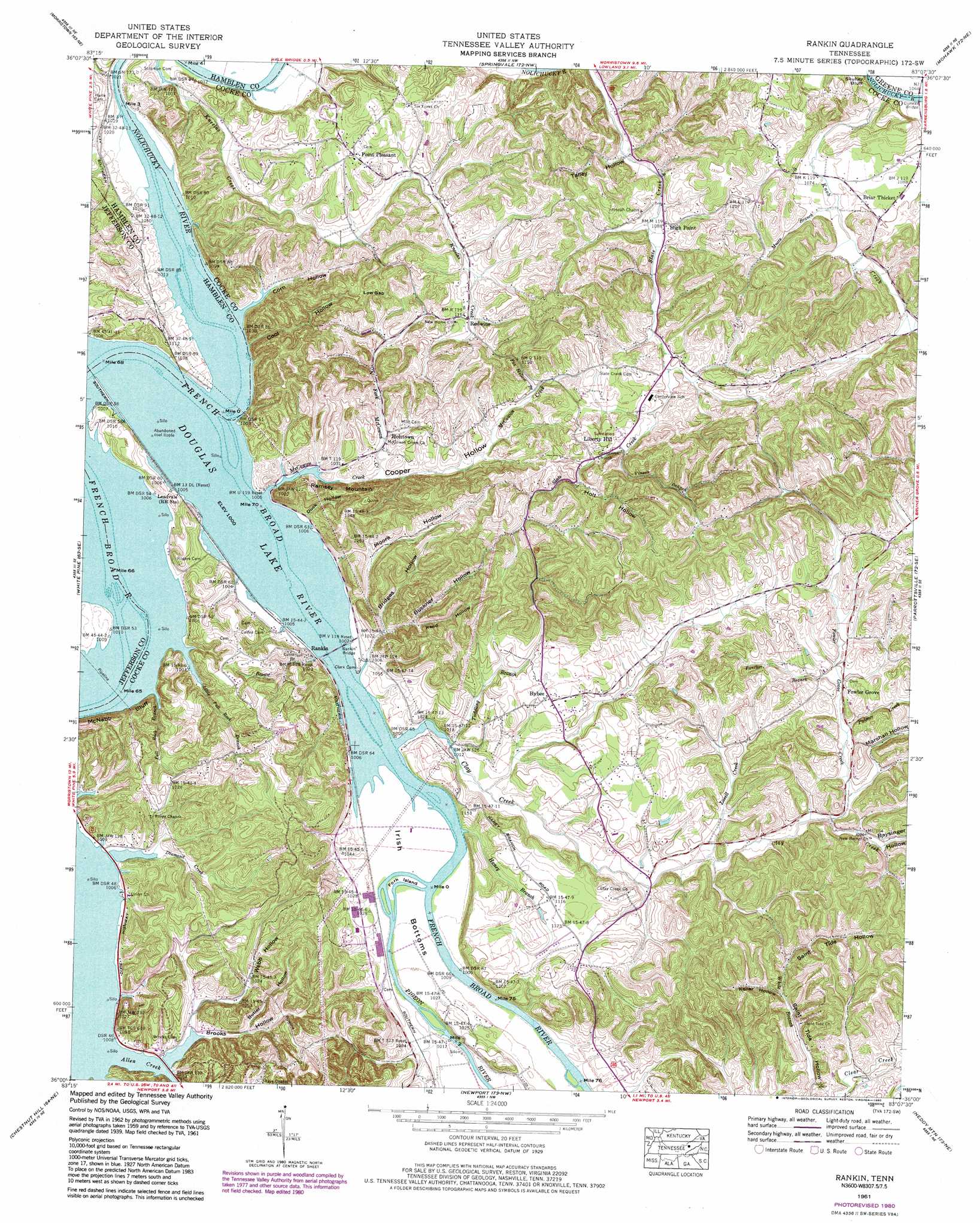
Rankin Topo Map Tennessee
To zoom in, hover over the map of Rankin
USGS Topo Quad 36083a2 - 1:24,000 scale
| Topo Map Name: | Rankin |
| USGS Topo Quad ID: | 36083a2 |
| Print Size: | ca. 21 1/4" wide x 27" high |
| Southeast Coordinates: | 36° N latitude / 83.125° W longitude |
| Map Center Coordinates: | 36.0625° N latitude / 83.1875° W longitude |
| U.S. State: | TN |
| Filename: | o36083a2.jpg |
| Download Map JPG Image: | Rankin topo map 1:24,000 scale |
| Map Type: | Topographic |
| Topo Series: | 7.5´ |
| Map Scale: | 1:24,000 |
| Source of Map Images: | United States Geological Survey (USGS) |
| Alternate Map Versions: |
Rankin TN 1935 Download PDF Buy paper map Rankin TN 1939 Download PDF Buy paper map Rankin TN 1939, updated 1960 Download PDF Buy paper map Rankin TN 1961, updated 1963 Download PDF Buy paper map Rankin TN 1961, updated 1980 Download PDF Buy paper map Rankin TN 2010 Download PDF Buy paper map Rankin TN 2013 Download PDF Buy paper map Rankin TN 2016 Download PDF Buy paper map |
1:24,000 Topo Quads surrounding Rankin
Avondale |
Bean Station |
Russellville |
Bulls Gap |
Mccloud |
Talbott |
Morristown |
Springvale |
Mohawk |
Mosheim |
Jefferson City |
White Pine |
Rankin |
Parrotsville |
Cedar Creek |
Shady Grove |
Chestnut Hill |
Newport |
Neddy Mountain |
Paint Rock |
Richardson Cove |
Jones Cove |
Hartford |
Waterville |
Lemon Gap |
> Back to 36083a1 at 1:100,000 scale
> Back to 36082a1 at 1:250,000 scale
> Back to U.S. Topo Maps home
Rankin topo map: Gazetteer
Rankin: Bars
Chunns Shoals elevation 305m 1000′Robinson Ford Shoals elevation 305m 1000′
Ten Island Shoals elevation 305m 1000′
Rankin: Bends
Irish Bottoms elevation 306m 1003′Rankin: Bridges
Conway Bridge elevation 320m 1049′Deep Ford Bridge (historical) elevation 310m 1017′
Rankin: Cliffs
McNabb Bluff elevation 351m 1151′Rankin: Crossings
Robinson Ford (historical) elevation 305m 1000′Solomon Ferry (historical) elevation 305m 1000′
Rankin: Flats
Rankin Bottoms elevation 305m 1000′Rankin: Gaps
Low Gap elevation 381m 1250′Rankin: Islands
Fork Island elevation 306m 1003′Harle Island (historical) elevation 305m 1000′
Jones Clark Island (historical) elevation 305m 1000′
Morgan Island (historical) elevation 305m 1000′
Morris Island (historical) elevation 305m 1000′
Peats Island elevation 307m 1007′
Stokelys Island (historical) elevation 305m 1000′
Ten Islands (historical) elevation 305m 1000′
Rankin: Populated Places
Briar Thicket elevation 333m 1092′Bybee elevation 340m 1115′
Fowler Grove elevation 346m 1135′
High Point elevation 330m 1082′
Holttown elevation 311m 1020′
Leadvale elevation 307m 1007′
Liberty Hill elevation 355m 1164′
Lilac (historical) elevation 322m 1056′
Point Pleasant elevation 355m 1164′
Rankin elevation 312m 1023′
Redwine elevation 348m 1141′
Rankin: Post Offices
Bybee Post Office elevation 339m 1112′Rankin: Ridges
Fowler Ridge elevation 349m 1145′Rankin: Streams
Allen Creek elevation 305m 1000′Brown Branch elevation 305m 1000′
Clay Creek elevation 305m 1000′
Diamond Creek elevation 305m 1000′
Fall Rock Branch elevation 305m 1000′
Fancher Branch elevation 341m 1118′
Fowler Grove Creek elevation 326m 1069′
Fox Hollow Branch elevation 330m 1082′
Haney Branch elevation 305m 1000′
Knob Creek elevation 321m 1053′
Little Fall Rock Branch elevation 305m 1000′
Lovell Creek elevation 319m 1046′
McCowan Creek elevation 305m 1000′
Moore Branch elevation 328m 1076′
Nolichucky River elevation 305m 1000′
North Fork McCowan Creek elevation 308m 1010′
Palmer Creek elevation 330m 1082′
Pigeon River elevation 305m 1000′
Taddling Branch elevation 305m 1000′
Vinson Branch elevation 340m 1115′
White Branch elevation 337m 1105′
Rankin: Summits
Ramsey Mountain elevation 429m 1407′Rankin: Valleys
Baysinger Hollow elevation 329m 1079′Benson Hollow elevation 370m 1213′
Bridges Hollow elevation 308m 1010′
Brooks Hollow elevation 305m 1000′
Brown Hollow elevation 305m 1000′
Buckner Hollow elevation 308m 1010′
Butler Hollow elevation 316m 1036′
Cool Hollow elevation 305m 1000′
Cooper Hollow elevation 305m 1000′
Corn Hollow elevation 305m 1000′
Duck Hollow elevation 306m 1003′
Holt Hollow elevation 346m 1135′
Keller Hollow elevation 339m 1112′
Marshall Hollow elevation 326m 1069′
Moore Hollow elevation 333m 1092′
Moore Hollow elevation 308m 1010′
Reed Hollow elevation 314m 1030′
Saint Tide Hollow elevation 327m 1072′
Sawyer Hollow elevation 313m 1026′
Talley Hollow elevation 312m 1023′
Webb Hollow elevation 305m 1000′
Rankin digital topo map on disk
Buy this Rankin topo map showing relief, roads, GPS coordinates and other geographical features, as a high-resolution digital map file on DVD:
Western Virginia & Southern West Virginia
Buy digital topo maps: Western Virginia & Southern West Virginia