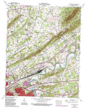
John Sevier Topo Map Tennessee
To zoom in, hover over the map of John Sevier
USGS Topo Quad 36083a7 - 1:24,000 scale
| Topo Map Name: | John Sevier |
| USGS Topo Quad ID: | 36083a7 |
| Print Size: | ca. 21 1/4" wide x 27" high |
| Southeast Coordinates: | 36° N latitude / 83.75° W longitude |
| Map Center Coordinates: | 36.0625° N latitude / 83.8125° W longitude |
| U.S. State: | TN |
| Filename: | o36083a7.jpg |
| Download Map JPG Image: | John Sevier topo map 1:24,000 scale |
| Map Type: | Topographic |
| Topo Series: | 7.5´ |
| Map Scale: | 1:24,000 |
| Source of Map Images: | United States Geological Survey (USGS) |
| Alternate Map Versions: |
John Sevier TN 1936 Download PDF Buy paper map John Sevier TN 1940 Download PDF Buy paper map John Sevier TN 1940, updated 1950 Download PDF Buy paper map John Sevier TN 1953, updated 1954 Download PDF Buy paper map John Sevier TN 1953, updated 1955 Download PDF Buy paper map John Sevier TN 1966, updated 1968 Download PDF Buy paper map John Sevier TN 1978, updated 1978 Download PDF Buy paper map John Sevier TN 1978, updated 1993 Download PDF Buy paper map John Sevier TN 2010 Download PDF Buy paper map John Sevier TN 2013 Download PDF Buy paper map John Sevier TN 2016 Download PDF Buy paper map |
1:24,000 Topo Quads surrounding John Sevier
> Back to 36083a1 at 1:100,000 scale
> Back to 36082a1 at 1:250,000 scale
> Back to U.S. Topo Maps home
John Sevier topo map: Gazetteer
John Sevier: Bars
Double Fish Trap Shoals elevation 250m 820′John Sevier: Bridges
J Will Taylor Bridge elevation 249m 816′James Edward Burke Bridge elevation 256m 839′
Ralph Adcock Bridge elevation 248m 813′
Ruggles Ferry Bridge (historical) elevation 249m 816′
John Sevier: Crossings
Armstrongs Ford elevation 249m 816′Interchange 392 elevation 286m 938′
Interchange 393 elevation 280m 918′
Interchange 394 elevation 260m 853′
Interchange 398 elevation 285m 935′
Ruggles Ferry (historical) elevation 249m 816′
John Sevier: Gaps
Fulton Gap elevation 295m 967′John Sevier: Islands
Armstrong Island elevation 254m 833′Cabbage Island elevation 250m 820′
John Sevier: Parks
Volunteer Park elevation 256m 839′John Sevier: Populated Places
Antioch elevation 304m 997′Arminda elevation 311m 1020′
Brookfield Acres elevation 347m 1138′
Carpenter Addition elevation 287m 941′
Caswell elevation 281m 921′
Chilhowee Hills elevation 265m 869′
Eastwood elevation 285m 935′
Happy Acres elevation 341m 1118′
Harbison Crossroads elevation 337m 1105′
Highpoint (historical) elevation 268m 879′
Holston Mobile Home Park elevation 280m 918′
John Sevier elevation 277m 908′
Kings Valley elevation 300m 984′
Loveland elevation 301m 987′
Maloneyville elevation 318m 1043′
Mayo (historical) elevation 290m 951′
McMillan elevation 263m 862′
Millertown elevation 286m 938′
Plantation Acres Mobile Home Park elevation 297m 974′
Ridgeview Heights elevation 399m 1309′
Ritta elevation 311m 1020′
Sentertown elevation 310m 1017′
Shipetown elevation 330m 1082′
Skaggston elevation 302m 990′
Spring Place elevation 295m 967′
Sunrise elevation 305m 1000′
Three Points elevation 285m 935′
Wooddale elevation 293m 961′
John Sevier: Rapids
Craigheads Shoals elevation 248m 813′John Sevier: Reservoirs
Mill Lake elevation 342m 1122′John Sevier: Ridges
McAnnally Ridge elevation 427m 1400′John Sevier: Springs
Cardwell Spring elevation 313m 1026′Crawford Spring elevation 311m 1020′
Cruze Spring elevation 348m 1141′
Duggan Spring elevation 324m 1062′
Link Spring elevation 308m 1010′
Mathews Spring elevation 316m 1036′
McMillan Spring elevation 314m 1030′
Netherland Heights Spring elevation 303m 994′
Vandergrift Spring elevation 341m 1118′
Wise Spring elevation 351m 1151′
John Sevier: Streams
Fawver Creek elevation 250m 820′Hogskin Branch elevation 298m 977′
Huckleberry Springs Branch elevation 285m 935′
Inman Branch elevation 256m 839′
Kerns Branch elevation 322m 1056′
Legg Creek elevation 249m 816′
Love Creek elevation 249m 816′
Mac Cash Branch elevation 251m 823′
Mile Branch elevation 304m 997′
Molly Branch elevation 295m 967′
Roseberry Creek elevation 254m 833′
Sinking Creek elevation 254m 833′
South Fork Beaver Creek elevation 328m 1076′
Strong Creek elevation 250m 820′
Woods Creek elevation 249m 816′
John Sevier: Summits
House Mountain elevation 629m 2063′John Pratt Hill elevation 341m 1118′
John Sevier digital topo map on disk
Buy this John Sevier topo map showing relief, roads, GPS coordinates and other geographical features, as a high-resolution digital map file on DVD:
Western Virginia & Southern West Virginia
Buy digital topo maps: Western Virginia & Southern West Virginia


