Morristown Topo Map Tennessee
To zoom in, hover over the map of Morristown
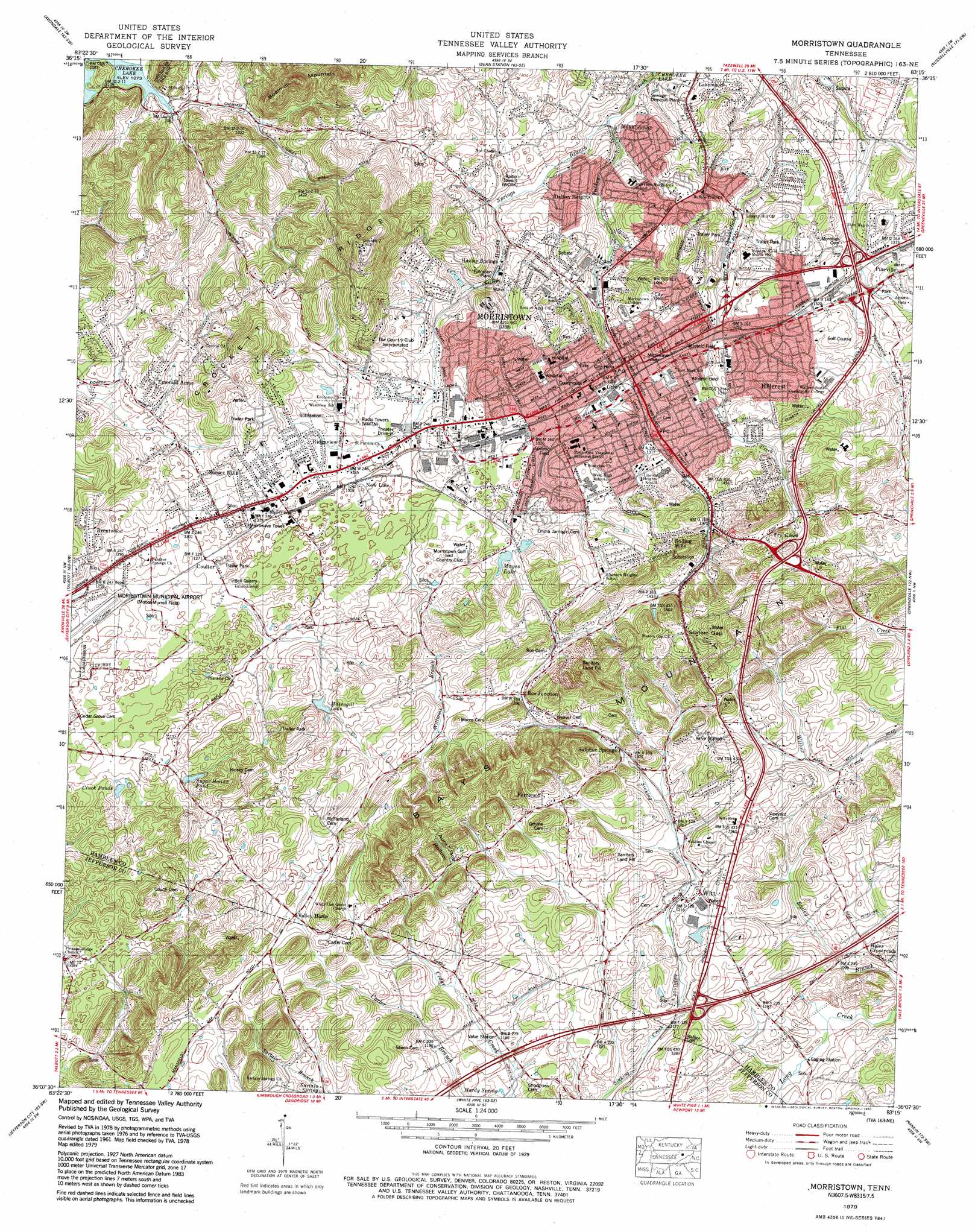
USGS Topo Quad 36083b3 - 1:24,000 scale
| Topo Map Name: | Morristown |
| USGS Topo Quad ID: | 36083b3 |
| Print Size: | ca. 21 1/4" wide x 27" high |
| Southeast Coordinates: | 36.125° N latitude / 83.25° W longitude |
| Map Center Coordinates: | 36.1875° N latitude / 83.3125° W longitude |
| U.S. State: | TN |
| Filename: | o36083b3.jpg |
| Download Map JPG Image: | Morristown topo map 1:24,000 scale |
| Map Type: | Topographic |
| Topo Series: | 7.5´ |
| Map Scale: | 1:24,000 |
| Source of Map Images: | United States Geological Survey (USGS) |
| Alternate Map Versions: |
Morristown TN 1935 Download PDF Buy paper map Morristown TN 1939 Download PDF Buy paper map Morristown TN 1939, updated 1954 Download PDF Buy paper map Morristown TN 1961, updated 1963 Download PDF Buy paper map Morristown TN 1961, updated 1971 Download PDF Buy paper map Morristown TN 1979, updated 1980 Download PDF Buy paper map Morristown TN 1979, updated 1980 Download PDF Buy paper map Morristown TN 2010 Download PDF Buy paper map Morristown TN 2013 Download PDF Buy paper map Morristown TN 2016 Download PDF Buy paper map |
1:24,000 Topo Quads surrounding Morristown
Tazewell |
Howard Quarter |
Swan Island |
Lee Valley |
Camelot |
Dutch Valley |
Avondale |
Bean Station |
Russellville |
Bulls Gap |
Joppa |
Talbott |
Morristown |
Springvale |
Mohawk |
New Market |
Jefferson City |
White Pine |
Rankin |
Parrotsville |
Douglas Dam |
Shady Grove |
Chestnut Hill |
Newport |
Neddy Mountain |
> Back to 36083a1 at 1:100,000 scale
> Back to 36082a1 at 1:250,000 scale
> Back to U.S. Topo Maps home
Morristown topo map: Gazetteer
Morristown: Airports
Moore-Murrell Airport elevation 395m 1295′Morristown: Crossings
Interchange 8 elevation 374m 1227′Morristown: Gaps
Statem Gap elevation 459m 1505′Morristown: Lakes
Barrett Pond elevation 383m 1256′Cluck Ponds elevation 375m 1230′
Masengill Lake elevation 411m 1348′
Sugar Hollow Pond elevation 394m 1292′
Morristown: Mines
Bell Quarry elevation 383m 1256′Morristown: Parks
Barron Park elevation 439m 1440′Jaycee Park elevation 396m 1299′
Lon Price Park elevation 433m 1420′
Morristown College Historic District elevation 426m 1397′
Morristown: Populated Places
Beechnut Subdivision elevation 438m 1437′Brentwood elevation 424m 1391′
Campbell Acres elevation 393m 1289′
Carter Acres elevation 390m 1279′
Casablanca elevation 443m 1453′
Corpening HIlls elevation 391m 1282′
Coulter elevation 386m 1266′
Crockett Ridge elevation 405m 1328′
Dalton Heights elevation 378m 1240′
Depew Addition elevation 424m 1391′
Dogwood Hills elevation 453m 1486′
Drinnon Heights elevation 372m 1220′
Echo Hills elevation 422m 1384′
Edgewood elevation 392m 1286′
Emerald Acres elevation 424m 1391′
Eureka Hills elevation 472m 1548′
Fernwood elevation 420m 1377′
Fernwood Heights elevation 410m 1345′
Greenwood Acres elevation 442m 1450′
Hales Crossroads elevation 339m 1112′
Hallmark Estates elevation 407m 1335′
Havley Springs elevation 366m 1200′
Hidden Acres elevation 443m 1453′
Hillcrest elevation 416m 1364′
Holly Hills elevation 442m 1450′
Kilgore Subdivision elevation 366m 1200′
Lakeview elevation 405m 1328′
Landmark Estates elevation 462m 1515′
Liberty Heights elevation 401m 1315′
Lynndale elevation 347m 1138′
Mapleview Acres elevation 397m 1302′
Monte Vista Estates elevation 444m 1456′
Morristown elevation 397m 1302′
Mulberry Acres elevation 383m 1256′
North Brook elevation 383m 1256′
Oakwood elevation 401m 1315′
Ridgeview elevation 409m 1341′
Roe elevation 426m 1397′
Roe Junction elevation 424m 1391′
Rolling Hills elevation 444m 1456′
Sequooyah Estates elevation 429m 1407′
Southern Heights elevation 444m 1456′
Sulphur Springs elevation 399m 1309′
Sunset Hills elevation 410m 1345′
Taylor Estates elevation 403m 1322′
The Colonies elevation 446m 1463′
The Meadows elevation 409m 1341′
Tigertown elevation 415m 1361′
Vantage View elevation 414m 1358′
West Hills elevation 416m 1364′
Westivew Woods elevation 420m 1377′
Westview elevation 433m 1420′
Wildwood elevation 427m 1400′
Witt elevation 366m 1200′
Witt Acres elevation 384m 1259′
Morristown: Post Offices
Henry Street Station Morristown Post Office elevation 390m 1279′Morristown Post Office elevation 402m 1318′
Morristown: Reservoirs
Mayes Lake elevation 409m 1341′Morristown: Ridges
Crockett Ridge elevation 462m 1515′Long Ridge elevation 448m 1469′
Morristown: Springs
Hardy Spring elevation 352m 1154′Sartain Spring elevation 381m 1250′
Sulphur Spring elevation 400m 1312′
Morristown: Streams
Havley Springs Branch elevation 338m 1108′Moyer Branch elevation 327m 1072′
Springs Branch elevation 339m 1112′
Thompson Creek elevation 387m 1269′
West Fork Creek elevation 393m 1289′
West Fork Turkey Creek elevation 393m 1289′
Williams Branch elevation 389m 1276′
Morristown: Trails
Buffalo Trail elevation 366m 1200′Morristown: Valleys
Aunt Jane Hollow elevation 411m 1348′Morristown digital topo map on disk
Buy this Morristown topo map showing relief, roads, GPS coordinates and other geographical features, as a high-resolution digital map file on DVD:
Western Virginia & Southern West Virginia
Buy digital topo maps: Western Virginia & Southern West Virginia