Talbott Topo Map Tennessee
To zoom in, hover over the map of Talbott
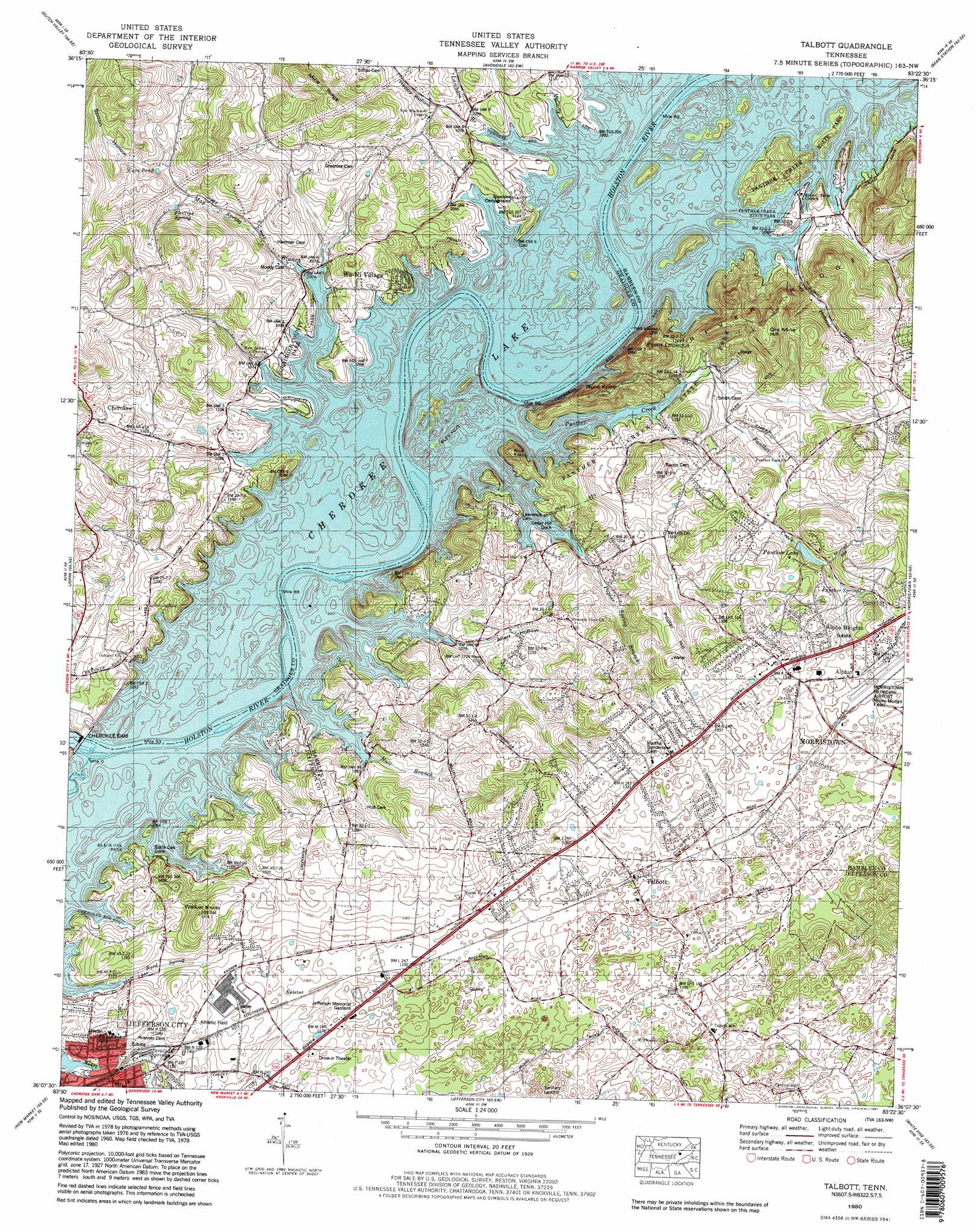
USGS Topo Quad 36083b4 - 1:24,000 scale
| Topo Map Name: | Talbott |
| USGS Topo Quad ID: | 36083b4 |
| Print Size: | ca. 21 1/4" wide x 27" high |
| Southeast Coordinates: | 36.125° N latitude / 83.375° W longitude |
| Map Center Coordinates: | 36.1875° N latitude / 83.4375° W longitude |
| U.S. State: | TN |
| Filename: | o36083b4.jpg |
| Download Map JPG Image: | Talbott topo map 1:24,000 scale |
| Map Type: | Topographic |
| Topo Series: | 7.5´ |
| Map Scale: | 1:24,000 |
| Source of Map Images: | United States Geological Survey (USGS) |
| Alternate Map Versions: |
Talbott TN 1935 Download PDF Buy paper map Talbott TN 1938, updated 1954 Download PDF Buy paper map Talbott TN 1940 Download PDF Buy paper map Talbott TN 1960, updated 1963 Download PDF Buy paper map Talbott TN 1980, updated 1981 Download PDF Buy paper map Talbott TN 1980, updated 1981 Download PDF Buy paper map Talbott TN 2010 Download PDF Buy paper map Talbott TN 2013 Download PDF Buy paper map Talbott TN 2016 Download PDF Buy paper map |
1:24,000 Topo Quads surrounding Talbott
Clouds |
Tazewell |
Howard Quarter |
Swan Island |
Lee Valley |
Powder Springs |
Dutch Valley |
Avondale |
Bean Station |
Russellville |
Luttrell |
Joppa |
Talbott |
Morristown |
Springvale |
Mascot |
New Market |
Jefferson City |
White Pine |
Rankin |
Boyds Creek |
Douglas Dam |
Shady Grove |
Chestnut Hill |
Newport |
> Back to 36083a1 at 1:100,000 scale
> Back to 36082a1 at 1:250,000 scale
> Back to U.S. Topo Maps home
Talbott topo map: Gazetteer
Talbott: Bars
Mays Ford Shoals elevation 327m 1072′Mossy Creek Shoals elevation 327m 1072′
Panthers Shoals elevation 327m 1072′
Talbott: Bends
Horseshoe Bend elevation 361m 1184′Talbott: Cliffs
Point Lookout elevation 450m 1476′Talbott: Crossings
Austin Ferry (historical) elevation 327m 1072′Collins Ford (historical) elevation 327m 1072′
Collons Ferry (historical) elevation 327m 1072′
Sycamore Ford (historical) elevation 327m 1072′
Talbott: Dams
Cherokee Dam elevation 330m 1082′Talbott: Islands
Bacon Island (historical) elevation 327m 1072′Mayes Islands (historical) elevation 327m 1072′
Mossy Creek Islands (historical) elevation 327m 1072′
Tarr Island (historical) elevation 327m 1072′
Talbott: Lakes
Cave Pond elevation 368m 1207′Long Pond (historical) elevation 327m 1072′
Talbott: Mines
Jarnagan Mine elevation 351m 1151′Mossy Creek Mine elevation 333m 1092′
Mount Pleasant Quarry elevation 371m 1217′
Panther Creek Quarry elevation 358m 1174′
Pearce Branch Quarry elevation 327m 1072′
River Ridge Quarry elevation 339m 1112′
Talbott Quarry elevation 360m 1181′
Talbott: Parks
Black Oak Park elevation 341m 1118′Grainger County Park elevation 332m 1089′
Johnson Ball Park elevation 351m 1151′
Nelson Merry Park elevation 373m 1223′
Panther Creek State Park elevation 341m 1118′
Talbott: Populated Places
Alpha elevation 391m 1282′Alpha Heights elevation 393m 1289′
Arrow Hills elevation 422m 1384′
Beacon Hills elevation 413m 1354′
Bluegrass elevation 394m 1292′
Briarcliff View elevation 413m 1354′
Britton Acres elevation 388m 1272′
Buell Acres elevation 389m 1276′
Cedar Hill Park elevation 337m 1105′
Cedar Hills elevation 380m 1246′
Cedar Hills elevation 334m 1095′
Cherokee elevation 374m 1227′
Fox Den elevation 414m 1358′
Green Acres elevation 361m 1184′
Hunters Ridge elevation 372m 1220′
Jackson Heights elevation 372m 1220′
Kathy Hills elevation 381m 1250′
Keister elevation 352m 1154′
Lake Park elevation 365m 1197′
Lakeshore Gardens elevation 393m 1289′
Lowe Acres elevation 361m 1184′
May Acres elevation 373m 1223′
May Springs (historical) elevation 327m 1072′
Meadowview elevation 391m 1282′
Melody Acres elevation 427m 1400′
Navaho Hills elevation 409m 1341′
Oakland elevation 348m 1141′
Panther Creek (historical) elevation 370m 1213′
Panther Hills elevation 396m 1299′
Panther Lake elevation 382m 1253′
Patterson Hills elevation 345m 1131′
Pleasant view elevation 368m 1207′
Pleasantview Acres elevation 368m 1207′
Point Seven elevation 342m 1122′
Prima Estates elevation 419m 1374′
Purkey Estates elevation 419m 1374′
Quail Hollow elevation 407m 1335′
Rambling Hills elevation 411m 1348′
Rock Town elevation 358m 1174′
Rolling Acres elevation 399m 1309′
Seven Oaks elevation 364m 1194′
Shiloh elevation 391m 1282′
Smokerise elevation 403m 1322′
Stithsville (historical) elevation 327m 1072′
Talbott elevation 368m 1207′
Wa-Ni Village elevation 328m 1076′
West Lake Estates elevation 340m 1115′
Westgate elevation 368m 1207′
Wilderness Shores elevation 358m 1174′
Willow Springs elevation 385m 1263′
Withers Subdivision elevation 346m 1135′
Wood Acres elevation 390m 1279′
Woodcrest Hills elevation 351m 1151′
Talbott: Post Offices
Jefferson City Post Office elevation 348m 1141′Talbott: Rapids
Horseshoe Bend Rapids elevation 327m 1072′Talbott: Reservoirs
Cherokee Lake elevation 330m 1082′Panther Lake elevation 353m 1158′
Talbott: Ridges
Mine Ridge elevation 459m 1505′River Ridge elevation 441m 1446′
Talbott: Springs
Blackwell Spring elevation 327m 1072′Byrd Spring elevation 327m 1072′
Jarnigan Spring elevation 329m 1079′
Lawrence Spring elevation 327m 1072′
May Spring elevation 327m 1072′
Panther Springs elevation 364m 1194′
Phillips Spring elevation 384m 1259′
Turley Spring elevation 327m 1072′
Talbott: Streams
Black Oak Creek elevation 327m 1072′Blackwell Branch elevation 327m 1072′
Hull Branch elevation 327m 1072′
Lambdin Branch elevation 327m 1072′
May Spring Branch elevation 327m 1072′
McCarty Branch elevation 327m 1072′
Panther Creek elevation 327m 1072′
Pearce Branch elevation 327m 1072′
Poplar Spring Branch elevation 327m 1072′
Talbott: Summits
Hunt Knob elevation 419m 1374′Murrell Hill elevation 384m 1259′
Ore Mine Hill elevation 472m 1548′
Poplar Hill elevation 411m 1348′
Rice Knob elevation 389m 1276′
Walker Knob elevation 403m 1322′
Talbott: Valleys
Allen Hollow elevation 327m 1072′Happy Hollow elevation 327m 1072′
Ivey Hollow elevation 348m 1141′
Spoon Hollow elevation 380m 1246′
Talbott digital topo map on disk
Buy this Talbott topo map showing relief, roads, GPS coordinates and other geographical features, as a high-resolution digital map file on DVD:
Western Virginia & Southern West Virginia
Buy digital topo maps: Western Virginia & Southern West Virginia