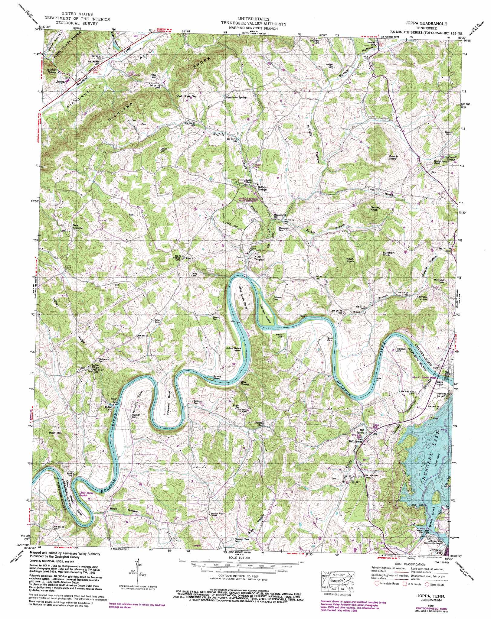
Joppa Topo Map Tennessee
To zoom in, hover over the map of Joppa
USGS Topo Quad 36083b5 - 1:24,000 scale
| Topo Map Name: | Joppa |
| USGS Topo Quad ID: | 36083b5 |
| Print Size: | ca. 21 1/4" wide x 27" high |
| Southeast Coordinates: | 36.125° N latitude / 83.5° W longitude |
| Map Center Coordinates: | 36.1875° N latitude / 83.5625° W longitude |
| U.S. State: | TN |
| Filename: | o36083b5.jpg |
| Download Map JPG Image: | Joppa topo map 1:24,000 scale |
| Map Type: | Topographic |
| Topo Series: | 7.5´ |
| Map Scale: | 1:24,000 |
| Source of Map Images: | United States Geological Survey (USGS) |
| Alternate Map Versions: |
Joppa TN 1935 Download PDF Buy paper map Joppa TN 1938, updated 1954 Download PDF Buy paper map Joppa TN 1939 Download PDF Buy paper map Joppa TN 1961, updated 1962 Download PDF Buy paper map Joppa TN 1961, updated 1977 Download PDF Buy paper map Joppa TN 1961, updated 1987 Download PDF Buy paper map Joppa TN 2010 Download PDF Buy paper map Joppa TN 2013 Download PDF Buy paper map Joppa TN 2016 Download PDF Buy paper map |
1:24,000 Topo Quads surrounding Joppa
Ausmus |
Clouds |
Tazewell |
Howard Quarter |
Swan Island |
Maynardville |
Powder Springs |
Dutch Valley |
Avondale |
Bean Station |
Graveston |
Luttrell |
Joppa |
Talbott |
Morristown |
John Sevier |
Mascot |
New Market |
Jefferson City |
White Pine |
Shooks Gap |
Boyds Creek |
Douglas Dam |
Shady Grove |
Chestnut Hill |
> Back to 36083a1 at 1:100,000 scale
> Back to 36082a1 at 1:250,000 scale
> Back to U.S. Topo Maps home
Joppa topo map: Gazetteer
Joppa: Bars
Buffalo Shoals elevation 276m 905′Combs Shoals elevation 282m 925′
Lost Creek Shoals elevation 268m 879′
Smoky Shoals elevation 274m 898′
Joppa: Bends
Haworth Bend elevation 302m 990′Horse Shoe Bend elevation 314m 1030′
Mule Shoe Bend elevation 280m 918′
Vineyard Bend elevation 294m 964′
Joppa: Bridges
John K Shields Bridge elevation 283m 928′Walker Bridge elevation 285m 935′
Joppa: Crossings
Dyers Ferry (historical) elevation 285m 935′Indian Cave Ferry (historical) elevation 270m 885′
Oars Ferry (historical) elevation 277m 908′
Smith Ferry (historical) elevation 277m 908′
Trogdons Ford elevation 274m 898′
Joppa: Gaps
Owl Hole Gap elevation 361m 1184′Joppa: Islands
Gilmore Island elevation 285m 935′Julian Nance Island elevation 275m 902′
Smoky Island elevation 273m 895′
Joppa: Lakes
Paskell Pond (historical) elevation 370m 1213′Joppa: Mines
Mitchell Quarry elevation 302m 990′Joppa: Parks
Buffalo Springs Game Farm elevation 355m 1164′Buffalo Springs State Game Farm elevation 349m 1145′
Joppa: Populated Places
Agreeable (historical) elevation 360m 1181′Buffalo Springs elevation 316m 1036′
Hammer Store elevation 375m 1230′
Joppa elevation 290m 951′
Massengill Mill elevation 300m 984′
Mill Spring elevation 300m 984′
New Corinth elevation 403m 1322′
Sycamore Spring elevation 367m 1204′
Tampico elevation 283m 928′
Joppa: Rapids
Little Jump Rapids elevation 267m 875′Joppa: Ridges
Indian Ridge elevation 436m 1430′Poor Valley Knobs elevation 385m 1263′
Joppa: Springs
Blue Spring elevation 281m 921′Buck Hollow Spring elevation 280m 918′
Buffalo Spring elevation 311m 1020′
Indian Cave Spring elevation 305m 1000′
Mill Spring elevation 301m 987′
Mitchell Spring elevation 399m 1309′
Sulphur Spring elevation 288m 944′
Sycamore Spring elevation 377m 1236′
Joppa: Streams
Bethel Branch elevation 297m 974′Buck Hollow Creek elevation 267m 875′
Buffalo Creek elevation 276m 905′
Byrd Spring Branch elevation 327m 1072′
Dry Branch elevation 271m 889′
Higgs Branch elevation 285m 935′
Mill Spring Creek elevation 280m 918′
Mossy Creek elevation 327m 1072′
West Branch elevation 277m 908′
Joppa: Summits
Burkhart Knob elevation 461m 1512′Combs Knob elevation 428m 1404′
Garvey Knob elevation 466m 1528′
Noah Knob elevation 461m 1512′
Rich Hill elevation 405m 1328′
Roach Knob elevation 501m 1643′
Joppa: Valleys
Buck Hollow elevation 271m 889′Buffalo Hollow elevation 297m 974′
Livingston Hollow elevation 301m 987′
Shackle Hollow elevation 282m 925′
Tate Hollow elevation 315m 1033′
Joppa digital topo map on disk
Buy this Joppa topo map showing relief, roads, GPS coordinates and other geographical features, as a high-resolution digital map file on DVD:
Western Virginia & Southern West Virginia
Buy digital topo maps: Western Virginia & Southern West Virginia