Bean Station Topo Map Tennessee
To zoom in, hover over the map of Bean Station
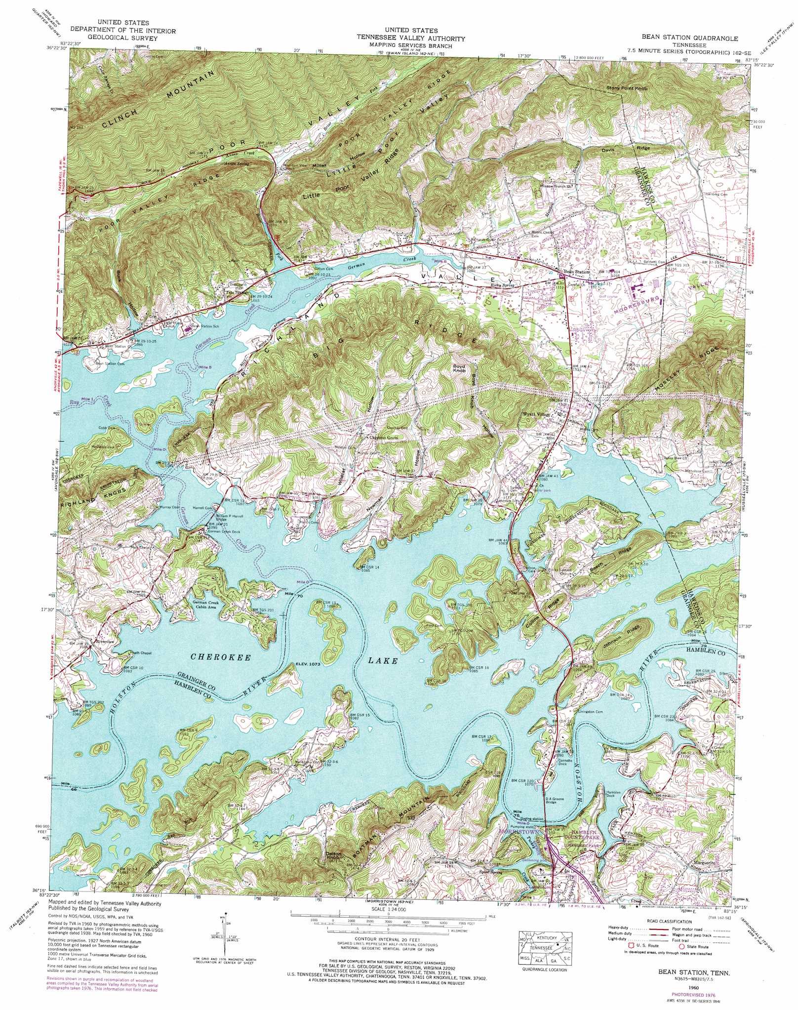
USGS Topo Quad 36083c3 - 1:24,000 scale
| Topo Map Name: | Bean Station |
| USGS Topo Quad ID: | 36083c3 |
| Print Size: | ca. 21 1/4" wide x 27" high |
| Southeast Coordinates: | 36.25° N latitude / 83.25° W longitude |
| Map Center Coordinates: | 36.3125° N latitude / 83.3125° W longitude |
| U.S. State: | TN |
| Filename: | o36083c3.jpg |
| Download Map JPG Image: | Bean Station topo map 1:24,000 scale |
| Map Type: | Topographic |
| Topo Series: | 7.5´ |
| Map Scale: | 1:24,000 |
| Source of Map Images: | United States Geological Survey (USGS) |
| Alternate Map Versions: |
Bean Station TN 1935 Download PDF Buy paper map Bean Station TN 1938, updated 1954 Download PDF Buy paper map Bean Station TN 1939 Download PDF Buy paper map Bean Station TN 1939 Download PDF Buy paper map Bean Station TN 1960, updated 1962 Download PDF Buy paper map Bean Station TN 1960, updated 1977 Download PDF Buy paper map Bean Station TN 2010 Download PDF Buy paper map Bean Station TN 2013 Download PDF Buy paper map Bean Station TN 2016 Download PDF Buy paper map |
1:24,000 Topo Quads surrounding Bean Station
Wheeler |
Coleman Gap |
Back Valley |
Sneedville |
Kyles Ford |
Tazewell |
Howard Quarter |
Swan Island |
Lee Valley |
Camelot |
Dutch Valley |
Avondale |
Bean Station |
Russellville |
Bulls Gap |
Joppa |
Talbott |
Morristown |
Springvale |
Mohawk |
New Market |
Jefferson City |
White Pine |
Rankin |
Parrotsville |
> Back to 36083a1 at 1:100,000 scale
> Back to 36082a1 at 1:250,000 scale
> Back to U.S. Topo Maps home
Bean Station topo map: Gazetteer
Bean Station: Bars
Coulters Shoals elevation 327m 1072′German Shoals elevation 327m 1072′
Harris Shoals elevation 327m 1072′
Marshalls Shoals elevation 327m 1072′
Marshalls Shoals elevation 327m 1072′
Sheltons Shoals elevation 327m 1072′
Bean Station: Bridges
D A Green Bridge elevation 327m 1072′William P Harrell Bridge elevation 327m 1072′
Bean Station: Crossings
Long Ferry (historical) elevation 327m 1072′Marshalls Ferry (historical) elevation 327m 1072′
Marshalls Ford (historical) elevation 327m 1072′
Sheltons Ford (historical) elevation 327m 1072′
Bean Station: Islands
Payne Island (historical) elevation 327m 1072′Sycamore Island (historical) elevation 327m 1072′
Bean Station: Parks
Grainger County Park elevation 335m 1099′Hamblen County Park elevation 355m 1164′
Harrell Park elevation 334m 1095′
Bean Station: Populated Places
Bean Station elevation 350m 1148′Beans elevation 337m 1105′
Cherokee Park elevation 351m 1151′
Corbin Estates elevation 367m 1204′
Crosby elevation 337m 1105′
East Ridge elevation 391m 1282′
Gaby Hills elevation 383m 1256′
Holston (historical) elevation 333m 1092′
Indian HIlls elevation 341m 1118′
Lakemoore elevation 359m 1177′
Lakewood Estates elevation 351m 1151′
Marguerite elevation 352m 1154′
Mary Chapel elevation 355m 1164′
Meadow Branch elevation 352m 1154′
Mountain View Meadows elevation 353m 1158′
Noeton (historical) elevation 327m 1072′
Ridgewood elevation 383m 1256′
Riverview elevation 335m 1099′
Rocky Summit (historical) elevation 328m 1076′
Tate Springs elevation 341m 1118′
Timbercrest elevation 340m 1115′
Wyatt Village elevation 342m 1122′
Bean Station: Post Offices
Bean Station Post Office elevation 350m 1148′Bean Station: Ridges
Beech Ridge elevation 377m 1236′Big Ridge elevation 490m 1607′
Boatman Mountain elevation 506m 1660′
Collins Ridge elevation 339m 1112′
Davis Ridge elevation 424m 1391′
Johnson Ridge elevation 376m 1233′
Little Poor Valley Ridge elevation 534m 1751′
Moseley Ridge elevation 590m 1935′
Bean Station: Springs
Annex Spring elevation 347m 1138′Cave Spring elevation 327m 1072′
Heath Spring elevation 327m 1072′
Rocky Spring elevation 328m 1076′
Spout Spring elevation 340m 1115′
Bean Station: Streams
Annex Creek elevation 332m 1089′Briar Fork elevation 327m 1072′
Gap Branch elevation 327m 1072′
German Creek elevation 327m 1072′
Manns Creek elevation 327m 1072′
Meadow Branch elevation 328m 1076′
Mill Spring Branch (historical) elevation 327m 1072′
Miller Branch elevation 331m 1085′
Ray Creek elevation 327m 1072′
Spring Creek elevation 327m 1072′
Stubblefield Creek elevation 343m 1125′
Turkey Creek elevation 327m 1072′
Wildcat Branch elevation 329m 1079′
Bean Station: Summits
Boyd Knob elevation 484m 1587′Dalton Knob elevation 502m 1646′
Stony Point Knob elevation 556m 1824′
Bean Station: Valleys
Boyd Knob Hollow elevation 327m 1072′Briar Hollow elevation 333m 1092′
Buck Hollow elevation 327m 1072′
Cave Spring Valley elevation 327m 1072′
Little Poor Valley elevation 335m 1099′
Miller Hollow elevation 335m 1099′
Mooresburg Valley elevation 327m 1072′
Newman Hollow elevation 327m 1072′
Sugar Hollow elevation 374m 1227′
Wildcat Hollow elevation 327m 1072′
Bean Station: Woods
Chestnut Grove elevation 390m 1279′Bean Station digital topo map on disk
Buy this Bean Station topo map showing relief, roads, GPS coordinates and other geographical features, as a high-resolution digital map file on DVD:
Western Virginia & Southern West Virginia
Buy digital topo maps: Western Virginia & Southern West Virginia