Lee Valley Topo Map Tennessee
To zoom in, hover over the map of Lee Valley
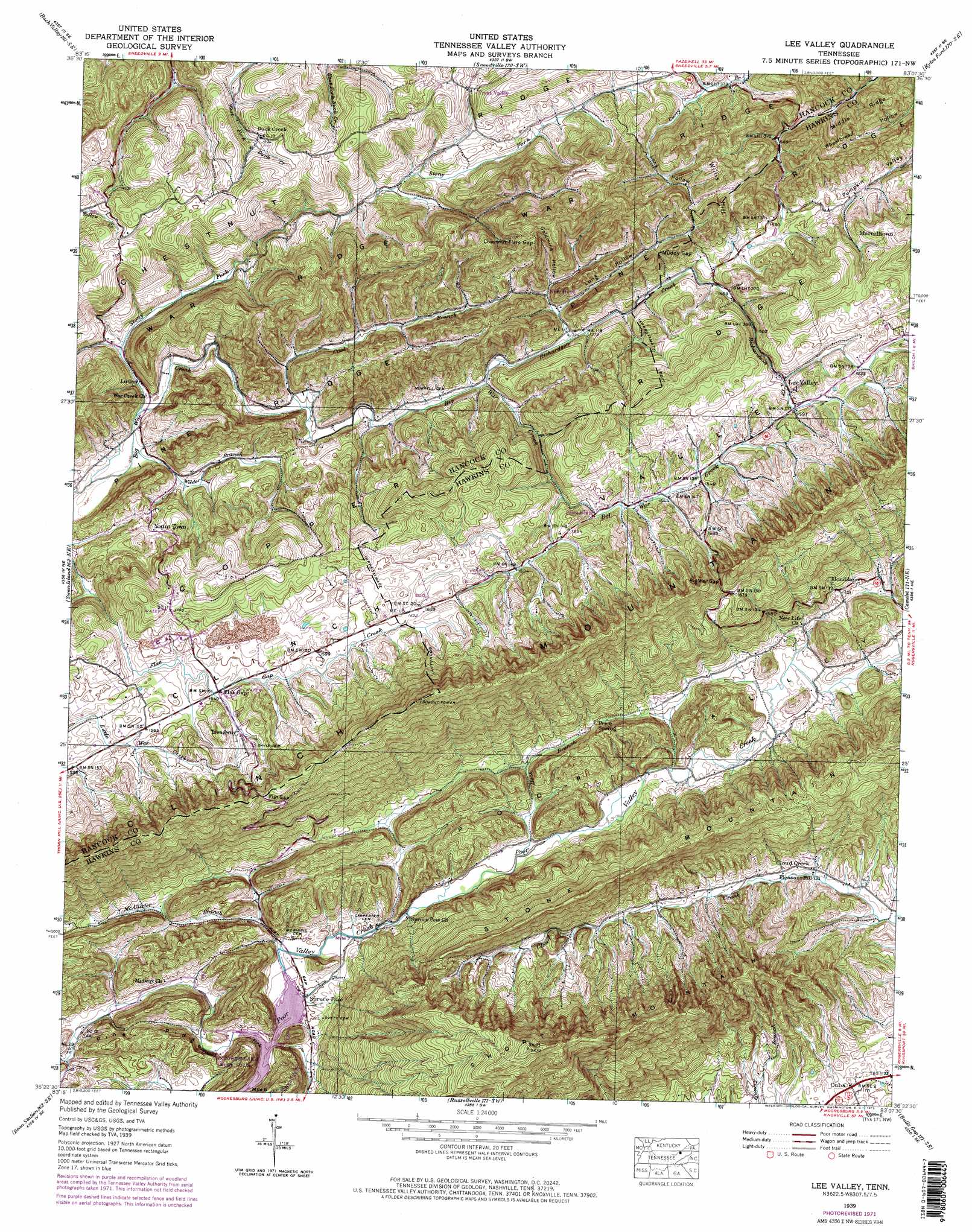
USGS Topo Quad 36083d2 - 1:24,000 scale
| Topo Map Name: | Lee Valley |
| USGS Topo Quad ID: | 36083d2 |
| Print Size: | ca. 21 1/4" wide x 27" high |
| Southeast Coordinates: | 36.375° N latitude / 83.125° W longitude |
| Map Center Coordinates: | 36.4375° N latitude / 83.1875° W longitude |
| U.S. State: | TN |
| Filename: | o36083d2.jpg |
| Download Map JPG Image: | Lee Valley topo map 1:24,000 scale |
| Map Type: | Topographic |
| Topo Series: | 7.5´ |
| Map Scale: | 1:24,000 |
| Source of Map Images: | United States Geological Survey (USGS) |
| Alternate Map Versions: |
Lee Valley TN 1935 Download PDF Buy paper map Lee Valley TN 1939, updated 1956 Download PDF Buy paper map Lee Valley TN 1939, updated 1973 Download PDF Buy paper map Lee Valley TN 1939, updated 1973 Download PDF Buy paper map Lee Valley TN 1940 Download PDF Buy paper map Lee Valley TN 2010 Download PDF Buy paper map Lee Valley TN 2013 Download PDF Buy paper map Lee Valley TN 2016 Download PDF Buy paper map |
1:24,000 Topo Quads surrounding Lee Valley
Ewing |
Rose Hill |
Hubbard Springs |
Ben Hur |
Stickleyville |
Coleman Gap |
Back Valley |
Sneedville |
Kyles Ford |
Looneys Gap |
Howard Quarter |
Swan Island |
Lee Valley |
Camelot |
Burem |
Avondale |
Bean Station |
Russellville |
Bulls Gap |
Mccloud |
Talbott |
Morristown |
Springvale |
Mohawk |
Mosheim |
> Back to 36083a1 at 1:100,000 scale
> Back to 36082a1 at 1:250,000 scale
> Back to U.S. Topo Maps home
Lee Valley topo map: Gazetteer
Lee Valley: Gaps
Big War Gap elevation 581m 1906′Chestnut Flats Gap elevation 567m 1860′
Flat Gap elevation 619m 2030′
Muddy Gap elevation 517m 1696′
Lee Valley: Mines
Price Quarry elevation 358m 1174′Lee Valley: Populated Places
Cloud Creek elevation 362m 1187′Cuba elevation 353m 1158′
Duck Creek elevation 467m 1532′
Friendship elevation 460m 1509′
Klondike elevation 402m 1318′
Lee Valley elevation 478m 1568′
Luther elevation 381m 1250′
Murrelltown elevation 575m 1886′
New Hope elevation 440m 1443′
Spruce Pine elevation 329m 1079′
Treadway elevation 486m 1594′
Trent Valley elevation 509m 1669′
Yount Town elevation 449m 1473′
Lee Valley: Post Offices
Treadway Post Office elevation 477m 1564′Lee Valley: Ranges
Clinch Mountain elevation 603m 1978′Lee Valley: Ridges
Chestnut Ridge elevation 532m 1745′Middle Ridge elevation 552m 1811′
Pine Ridge elevation 428m 1404′
Lee Valley: Springs
Price Spring elevation 385m 1263′Lee Valley: Streams
Caney Fork elevation 328m 1076′Cool Branch elevation 391m 1282′
Heck Branch elevation 336m 1102′
McAllister Branch elevation 328m 1076′
Richardson Creek elevation 407m 1335′
Stony Fork elevation 377m 1236′
Wilder Branch elevation 375m 1230′
Lee Valley: Summits
Short Mountain elevation 808m 2650′Willis Hill elevation 598m 1961′
Lee Valley: Valleys
Bear Hollow elevation 422m 1384′Goldmine Hollow elevation 451m 1479′
Long Hollow elevation 431m 1414′
Long Hollow elevation 440m 1443′
Seal Hollow elevation 444m 1456′
Lee Valley digital topo map on disk
Buy this Lee Valley topo map showing relief, roads, GPS coordinates and other geographical features, as a high-resolution digital map file on DVD:
Western Virginia & Southern West Virginia
Buy digital topo maps: Western Virginia & Southern West Virginia