Kyles Ford Topo Map Tennessee
To zoom in, hover over the map of Kyles Ford
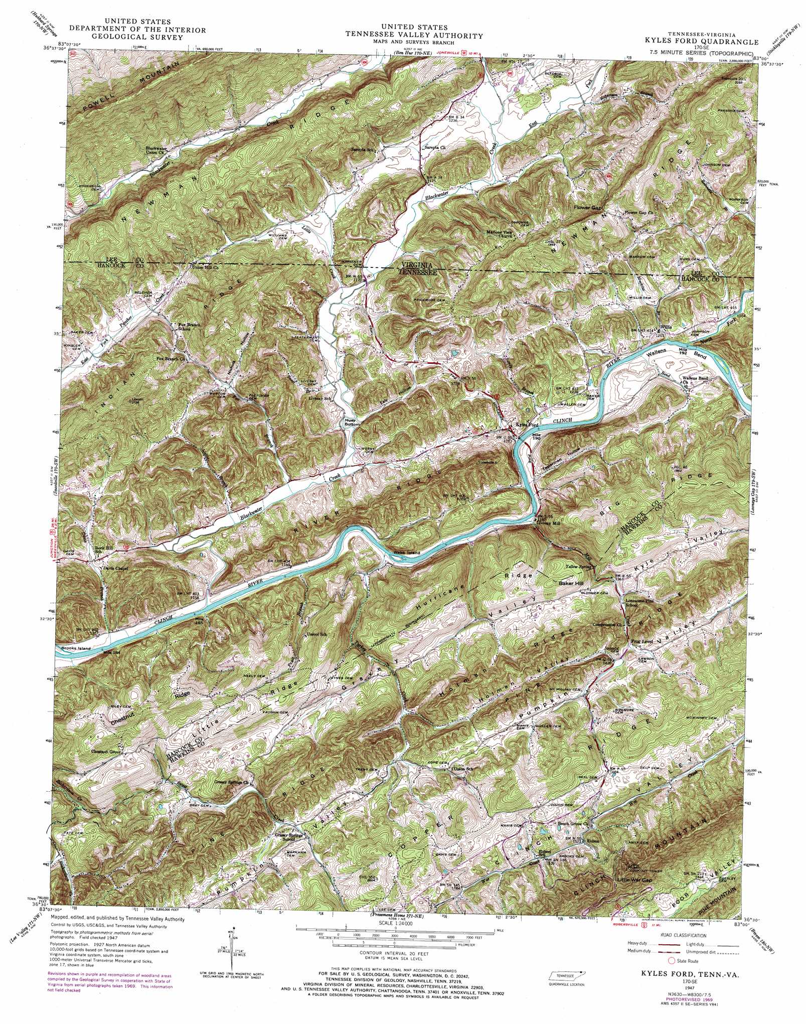
USGS Topo Quad 36083e1 - 1:24,000 scale
| Topo Map Name: | Kyles Ford |
| USGS Topo Quad ID: | 36083e1 |
| Print Size: | ca. 21 1/4" wide x 27" high |
| Southeast Coordinates: | 36.5° N latitude / 83° W longitude |
| Map Center Coordinates: | 36.5625° N latitude / 83.0625° W longitude |
| U.S. States: | TN, VA |
| Filename: | o36083e1.jpg |
| Download Map JPG Image: | Kyles Ford topo map 1:24,000 scale |
| Map Type: | Topographic |
| Topo Series: | 7.5´ |
| Map Scale: | 1:24,000 |
| Source of Map Images: | United States Geological Survey (USGS) |
| Alternate Map Versions: |
Kyles Ford TN 1935 Download PDF Buy paper map Kyles Ford TN 1950 Download PDF Buy paper map Kyles Ford TN 1969, updated 1970 Download PDF Buy paper map Kyles Ford TN 1976, updated 1981 Download PDF Buy paper map Kyles Ford TN 2010 Download PDF Buy paper map Kyles Ford TN 2013 Download PDF Buy paper map Kyles Ford TN 2016 Download PDF Buy paper map |
1:24,000 Topo Quads surrounding Kyles Ford
Harlan |
Evarts |
Pennington Gap |
Keokee |
Big Stone Gap |
Rose Hill |
Hubbard Springs |
Ben Hur |
Stickleyville |
Duffield |
Back Valley |
Sneedville |
Kyles Ford |
Looneys Gap |
Plum Grove |
Swan Island |
Lee Valley |
Camelot |
Burem |
Stony Point |
Bean Station |
Russellville |
Bulls Gap |
Mccloud |
Baileyton |
> Back to 36083e1 at 1:100,000 scale
> Back to 36082a1 at 1:250,000 scale
> Back to U.S. Topo Maps home
Kyles Ford topo map: Gazetteer
Kyles Ford: Bars
Kyles Shoals elevation 345m 1131′Kyles Ford: Bends
Huey Bottom elevation 353m 1158′Wallens Bend elevation 352m 1154′
Kyles Ford: Bridges
Kyles Ford Bridge elevation 346m 1135′Kyles Ford: Gaps
Flower Gap elevation 495m 1624′Little War Gap elevation 602m 1975′
War Gap elevation 421m 1381′
Kyles Ford: Islands
Webb Island elevation 347m 1138′Kyles Ford: Populated Places
Chestnut Grove elevation 507m 1663′Eidson elevation 464m 1522′
Fox Branch elevation 385m 1263′
Kyles Ford elevation 357m 1171′
Livesay Mill elevation 351m 1151′
Rock Hill elevation 376m 1233′
Willis elevation 365m 1197′
Kyles Ford: Post Offices
Eidson Post Office elevation 518m 1699′Kyles Ford Post Office elevation 370m 1213′
Kyles Ford: Ranges
Copper Ridge elevation 607m 1991′Kyles Ford: Ridges
Holman Ridge elevation 574m 1883′Hurricane Ridge elevation 490m 1607′
Indian Ridge elevation 628m 2060′
Little Ridge elevation 561m 1840′
Newman Ridge elevation 565m 1853′
Newman Ridge elevation 493m 1617′
Pine Ridge elevation 590m 1935′
Pine Ridge elevation 548m 1797′
River Ridge elevation 417m 1368′
Kyles Ford: Springs
Eidson Spring elevation 469m 1538′Yellow Spring elevation 401m 1315′
Kyles Ford: Streams
Bend Branch elevation 346m 1135′Blackwater Creek elevation 346m 1135′
Blackwater Creek elevation 346m 1135′
Davis Branch elevation 345m 1131′
East Fork Blackwater Creek elevation 357m 1171′
Fox Branch elevation 362m 1187′
Little Creek elevation 353m 1158′
Little Creek elevation 354m 1161′
Machine Branch elevation 346m 1135′
Mill Creek elevation 346m 1135′
Nattie Branch elevation 348m 1141′
North Fork Clinch River elevation 347m 1138′
North Fork Clinch River elevation 347m 1138′
Pratt Branch elevation 345m 1131′
Robertson Branch elevation 366m 1200′
Sandy Branch elevation 346m 1135′
Sweet Branch elevation 353m 1158′
Sweet Creek elevation 393m 1289′
Turkey Creek elevation 345m 1131′
Kyles Ford: Summits
Baker Hill elevation 530m 1738′Kyles Ford: Valleys
Black Sheep Hollow elevation 436m 1430′Ealy Hollow elevation 353m 1158′
Gravely Valley elevation 459m 1505′
Helton Hollow elevation 443m 1453′
Holman Valley elevation 430m 1410′
Nichols Hollow elevation 383m 1256′
Testerman Hollow elevation 352m 1154′
Wheatbread Hollow elevation 413m 1354′
Kyles Ford digital topo map on disk
Buy this Kyles Ford topo map showing relief, roads, GPS coordinates and other geographical features, as a high-resolution digital map file on DVD:
Western Virginia & Southern West Virginia
Buy digital topo maps: Western Virginia & Southern West Virginia