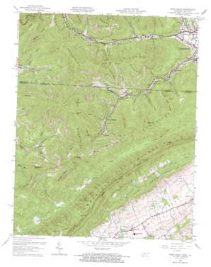
Fork Ridge Topo Map Tennessee
To zoom in, hover over the map of Fork Ridge
USGS Topo Quad 36083e7 - 1:24,000 scale
| Topo Map Name: | Fork Ridge |
| USGS Topo Quad ID: | 36083e7 |
| Print Size: | ca. 21 1/4" wide x 27" high |
| Southeast Coordinates: | 36.5° N latitude / 83.75° W longitude |
| Map Center Coordinates: | 36.5625° N latitude / 83.8125° W longitude |
| U.S. States: | TN, KY |
| Filename: | o36083e7.jpg |
| Download Map JPG Image: | Fork Ridge topo map 1:24,000 scale |
| Map Type: | Topographic |
| Topo Series: | 7.5´ |
| Map Scale: | 1:24,000 |
| Source of Map Images: | United States Geological Survey (USGS) |
| Alternate Map Versions: |
Mingo Mountains TN 1935 Download PDF Buy paper map Mingo Mountains TN 1950 Download PDF Buy paper map Fork Ridge TN 1959, updated 1960 Download PDF Buy paper map Fork Ridge TN 1959, updated 1973 Download PDF Buy paper map Fork Ridge TN 2010 Download PDF Buy paper map Fork Ridge TN 2013 Download PDF Buy paper map Fork Ridge TN 2016 Download PDF Buy paper map |
1:24,000 Topo Quads surrounding Fork Ridge
> Back to 36083e1 at 1:100,000 scale
> Back to 36082a1 at 1:250,000 scale
> Back to U.S. Topo Maps home
Fork Ridge topo map: Gazetteer
Fork Ridge: Dams
Spruce Lick Fresh Water Dam elevation 498m 1633′Spruce Lick Slurry Refuse Dam elevation 469m 1538′
Fork Ridge: Flats
Bowman Flats elevation 568m 1863′Cup Fields elevation 511m 1676′
Fork Ridge: Gaps
Big Coal Gap elevation 739m 2424′Carr Gap elevation 709m 2326′
Cup Gap elevation 679m 2227′
Hopper Gap elevation 721m 2365′
Jones Gap elevation 798m 2618′
Little Coal Gap elevation 712m 2335′
Rich Gap elevation 647m 2122′
Fork Ridge: Mines
Fork Ridge Mine elevation 540m 1771′Mooneyham Mine elevation 808m 2650′
Fork Ridge: Pillars
Arch Rock elevation 703m 2306′Fork Ridge: Populated Places
Bryson Mountain elevation 535m 1755′Capito elevation 533m 1748′
Edgewood elevation 401m 1315′
Fork Ridge elevation 475m 1558′
Manring elevation 562m 1843′
Motch elevation 428m 1404′
Noetown elevation 364m 1194′
Powell Valley elevation 385m 1263′
Premier elevation 377m 1236′
Reliance elevation 506m 1660′
Stony Fork Junction elevation 360m 1181′
Vanbebber Spring elevation 371m 1217′
Yellow Creek elevation 411m 1348′
Fork Ridge: Post Offices
Bosworth Post Office (historical) elevation 425m 1394′Fork Ridge: Reservoirs
Consolidation Coal Water Supply Lake elevation 498m 1633′Spruce Lick Slurry Refuse Impound elevation 469m 1538′
Fork Ridge: Ridges
Bald Spur elevation 915m 3001′Bull Ridge elevation 895m 2936′
Fork Ridge elevation 793m 2601′
Jones Spur elevation 864m 2834′
Maiden Ridge elevation 792m 2598′
Mingo Mountains elevation 732m 2401′
Turner Spur elevation 858m 2814′
White Oak Spur elevation 913m 2995′
Yellow Creek Ridge elevation 822m 2696′
Fork Ridge: Springs
Vanbebber Spring elevation 371m 1217′Fork Ridge: Streams
Beans Fork elevation 364m 1194′Beech Branch elevation 447m 1466′
Burrell Creek elevation 471m 1545′
Cabin Creek elevation 476m 1561′
Coal Creek elevation 603m 1978′
Coal Creek elevation 505m 1656′
Fortner Branch elevation 394m 1292′
Hignite Creek elevation 416m 1364′
Hurricane Creek elevation 447m 1466′
Jones Branch elevation 459m 1505′
Jones Branch elevation 475m 1558′
Langley Branch elevation 387m 1269′
Langley Branch elevation 385m 1263′
Long Branch elevation 453m 1486′
Marsee Branch elevation 433m 1420′
Martins Branch elevation 469m 1538′
Pigeon Roost Branch elevation 469m 1538′
Rock Lick Branch elevation 389m 1276′
Rockhouse Branch elevation 508m 1666′
Shade Branch elevation 404m 1325′
Slickrock Branch elevation 393m 1289′
Spruce Lick Branch elevation 465m 1525′
Steve Creek elevation 442m 1450′
Steve Creek elevation 443m 1453′
Sues Branch elevation 479m 1571′
Sugan Branch elevation 536m 1758′
Watson Branch elevation 425m 1394′
Fork Ridge: Summits
Bryson Mountain elevation 976m 3202′Chimney Rocks elevation 716m 2349′
Double Mountain elevation 715m 2345′
Horseshoe Mountain elevation 803m 2634′
Nicholson Mountain elevation 873m 2864′
North Mountain elevation 732m 2401′
Rich Mountain elevation 860m 2821′
Fork Ridge: Valleys
Bowman Hollow elevation 456m 1496′Buckeye Hollow elevation 475m 1558′
Buckeye Hollow elevation 472m 1548′
Cabin Hollow elevation 470m 1541′
Chalk Cave Hollow elevation 472m 1548′
Crane Roost Hollow elevation 465m 1525′
Hunt Town Hollow elevation 611m 2004′
Indian Springs Hollow elevation 463m 1519′
Klondike Hollow elevation 560m 1837′
Mingo Hollow elevation 359m 1177′
Mingo Hollow elevation 359m 1177′
Pigeon Roost Hollow elevation 475m 1558′
Stony Hollow elevation 367m 1204′
Stony Hollow elevation 366m 1200′
Sugar Hollow elevation 548m 1797′
Taylor Hollow elevation 472m 1548′
Watson Hollow elevation 441m 1446′
Fork Ridge digital topo map on disk
Buy this Fork Ridge topo map showing relief, roads, GPS coordinates and other geographical features, as a high-resolution digital map file on DVD:
Western Virginia & Southern West Virginia
Buy digital topo maps: Western Virginia & Southern West Virginia


