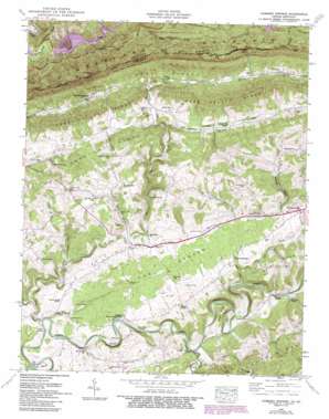
Hubbard Springs Topo Map Virginia
To zoom in, hover over the map of Hubbard Springs
USGS Topo Quad 36083f2 - 1:24,000 scale
| Topo Map Name: | Hubbard Springs |
| USGS Topo Quad ID: | 36083f2 |
| Print Size: | ca. 21 1/4" wide x 27" high |
| Southeast Coordinates: | 36.625° N latitude / 83.125° W longitude |
| Map Center Coordinates: | 36.6875° N latitude / 83.1875° W longitude |
| U.S. States: | VA, KY |
| Filename: | o36083f2.jpg |
| Download Map JPG Image: | Hubbard Springs topo map 1:24,000 scale |
| Map Type: | Topographic |
| Topo Series: | 7.5´ |
| Map Scale: | 1:24,000 |
| Source of Map Images: | United States Geological Survey (USGS) |
| Alternate Map Versions: |
Hubbard Springs VA 1935 Download PDF Buy paper map Hubbard Springs VA 1946, updated 1957 Download PDF Buy paper map Hubbard Springs VA 1946, updated 1970 Download PDF Buy paper map Hubbard Springs VA 1946, updated 1990 Download PDF Buy paper map Hubbard Springs VA 1946, updated 1992 Download PDF Buy paper map Hubbard Springs VA 1947, updated 1949 Download PDF Buy paper map Hubbard Springs VA 1976, updated 1981 Download PDF Buy paper map Hubbard Springs VA 2011 Download PDF Buy paper map Hubbard Springs VA 2013 Download PDF Buy paper map Hubbard Springs VA 2016 Download PDF Buy paper map |
1:24,000 Topo Quads surrounding Hubbard Springs
> Back to 36083e1 at 1:100,000 scale
> Back to 36082a1 at 1:250,000 scale
> Back to U.S. Topo Maps home
Hubbard Springs topo map: Gazetteer
Hubbard Springs: Arches
Natural Bridge elevation 391m 1282′Hubbard Springs: Bars
White Shoals elevation 372m 1220′Hubbard Springs: Bends
Tyler Bend elevation 395m 1295′Wilder Bend elevation 427m 1400′
Hubbard Springs: Bridges
Flanary Bridge elevation 376m 1233′Hurricane Bridge elevation 381m 1250′
Hubbard Springs: Crossings
Hall Ford elevation 368m 1207′Towell Ford elevation 374m 1227′
Hubbard Springs: Gaps
Cranks Gap elevation 895m 2936′Cranks Gap elevation 885m 2903′
Doubling Gap elevation 878m 2880′
Hubbard Gap elevation 451m 1479′
Hubbard Springs Gap elevation 799m 2621′
Hubbard Springs: Populated Places
Cedar Hill elevation 484m 1587′Fleenortown elevation 483m 1584′
Hockett elevation 476m 1561′
Hubbard Springs elevation 472m 1548′
Jonesville Camp Ground elevation 430m 1410′
Ocoonita elevation 511m 1676′
Hubbard Springs: Ranges
Cumberland Mountain elevation 612m 2007′Hubbard Springs: Reservoirs
Herb Smith Lake elevation 428m 1404′Hubbard Springs: Ridges
Chestnut Ridge elevation 476m 1561′Hubbard Springs: Springs
Beech Spring elevation 497m 1630′Spout Spring elevation 379m 1243′
Hubbard Springs: Streams
Batie Creek elevation 382m 1253′Dry Creek elevation 375m 1230′
Fleenortown Creek elevation 402m 1318′
Hardy Creek elevation 372m 1220′
Little Yellow Branch elevation 379m 1243′
Sugar Run elevation 424m 1391′
Town Branch elevation 382m 1253′
Trading Creek elevation 420m 1377′
Troublesome Creek elevation 433m 1420′
Wallen Creek elevation 377m 1236′
Hubbard Springs: Summits
Notch Rock elevation 893m 2929′Notch Rock elevation 866m 2841′
Yellow Rock elevation 858m 2814′
Yellow Rock elevation 857m 2811′
Hubbard Springs: Tunnels
Wagonroad Tunnel elevation 783m 2568′Wagonroad Tunnel elevation 764m 2506′
Hubbard Springs: Valleys
Caney Hollow elevation 417m 1368′Kinzer Hollow elevation 390m 1279′
Hubbard Springs: Woods
The Cedars elevation 415m 1361′Hubbard Springs digital topo map on disk
Buy this Hubbard Springs topo map showing relief, roads, GPS coordinates and other geographical features, as a high-resolution digital map file on DVD:
Western Virginia & Southern West Virginia
Buy digital topo maps: Western Virginia & Southern West Virginia


