Kayjay Topo Map Kentucky
To zoom in, hover over the map of Kayjay
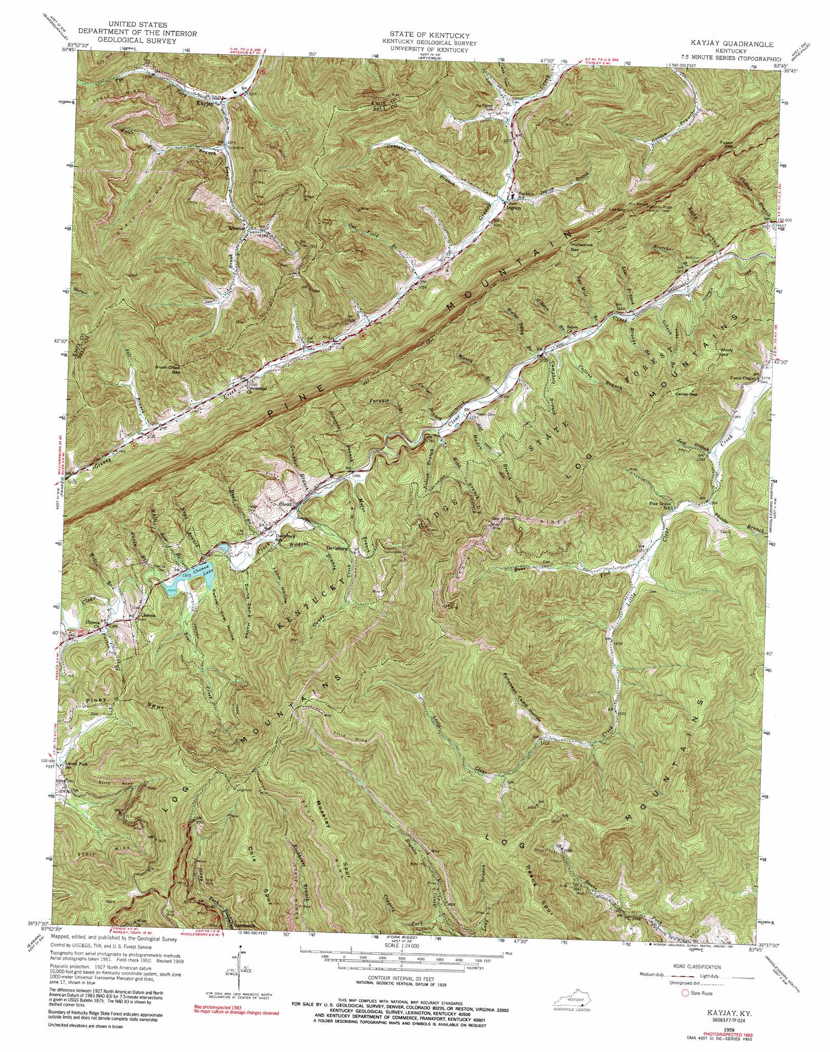
USGS Topo Quad 36083f7 - 1:24,000 scale
| Topo Map Name: | Kayjay |
| USGS Topo Quad ID: | 36083f7 |
| Print Size: | ca. 21 1/4" wide x 27" high |
| Southeast Coordinates: | 36.625° N latitude / 83.75° W longitude |
| Map Center Coordinates: | 36.6875° N latitude / 83.8125° W longitude |
| U.S. State: | KY |
| Filename: | o36083f7.jpg |
| Download Map JPG Image: | Kayjay topo map 1:24,000 scale |
| Map Type: | Topographic |
| Topo Series: | 7.5´ |
| Map Scale: | 1:24,000 |
| Source of Map Images: | United States Geological Survey (USGS) |
| Alternate Map Versions: |
Davisburg KY 1952, updated 1954 Download PDF Buy paper map Kayjay KY 1959, updated 1960 Download PDF Buy paper map Kayjay KY 1959, updated 1968 Download PDF Buy paper map Kayjay KY 1959, updated 1991 Download PDF Buy paper map Kayjay KY 2010 Download PDF Buy paper map Kayjay KY 2013 Download PDF Buy paper map Kayjay KY 2016 Download PDF Buy paper map |
1:24,000 Topo Quads surrounding Kayjay
Corbin |
Heidrick |
Fount |
Scalf |
Beverly |
Rockholds |
Barbourville |
Artemus |
Pineville |
Balkan |
Saxton |
Frakes |
Kayjay |
Middlesboro North |
Varilla |
Jellico East |
Eagan |
Fork Ridge |
Middlesboro South |
Wheeler |
La Follette |
Well Spring |
Ausmus |
Clouds |
Tazewell |
> Back to 36083e1 at 1:100,000 scale
> Back to 36082a1 at 1:250,000 scale
> Back to U.S. Topo Maps home
Kayjay topo map: Gazetteer
Kayjay: Forests
Kentucky Ridge State Forest elevation 591m 1938′Kayjay: Gaps
Brush Creek Gap elevation 418m 1371′Carter Gap elevation 629m 2063′
Fuson Gap elevation 650m 2132′
Horseshoe Gap elevation 592m 1942′
Lee Gap elevation 643m 2109′
Windy Gap elevation 513m 1683′
Kayjay: Mines
A Carrp Mine (historical) elevation 433m 1420′Tye Fork Coal Company (historical) elevation 485m 1591′
Kayjay: Populated Places
Chenoa elevation 441m 1446′Davisburg elevation 442m 1450′
Garmeada elevation 635m 2083′
Ingram elevation 314m 1030′
Kayjay elevation 327m 1072′
Olcott elevation 391m 1282′
Wheeler elevation 343m 1125′
Kayjay: Post Offices
Kayjay Post Office (historical) elevation 322m 1056′Wheeler Post Office (historical) elevation 340m 1115′
Kayjay: Ranges
Log Mountains elevation 893m 2929′Kayjay: Reservoirs
Chenoa Lake elevation 409m 1341′Kayjay: Ridges
Beans Spur elevation 896m 2939′Cole Spur elevation 846m 2775′
Log Mountains elevation 893m 2929′
Moseley Spur elevation 949m 3113′
Kayjay: Streams
Bear Branch elevation 320m 1049′Bear Creek elevation 409m 1341′
Becky Branch elevation 379m 1243′
Bens Fork elevation 404m 1325′
Bratcher Branch elevation 366m 1200′
Brooks Branch elevation 369m 1210′
Campbell Branch elevation 372m 1220′
Caney Creek elevation 387m 1269′
Carter Branch elevation 376m 1233′
Centers Branch elevation 313m 1026′
Collins Branch elevation 372m 1220′
Coppers Fork elevation 504m 1653′
Furnace Branch elevation 383m 1256′
Fuson Branch elevation 414m 1358′
Gamphor Branch elevation 393m 1289′
Gibson Branch elevation 372m 1220′
Gibson Branch elevation 366m 1200′
Head Branch elevation 389m 1276′
Ingram Branch elevation 325m 1066′
Law Branch elevation 309m 1013′
Lee Branch elevation 368m 1207′
Madon Branch elevation 375m 1230′
Major Branch elevation 387m 1269′
Mason Branch elevation 372m 1220′
Nelson Branch elevation 377m 1236′
Newt Branch elevation 404m 1325′
Oat Field Branch elevation 319m 1046′
Partin Branch elevation 424m 1391′
Phoebe Branch elevation 389m 1276′
Saw Mill Branch elevation 369m 1210′
Sill Branch elevation 341m 1118′
Simpson Branch elevation 386m 1266′
Tye Fork elevation 320m 1049′
Water Tank Branch elevation 372m 1220′
Webb Branch elevation 389m 1276′
White Row Branch elevation 414m 1358′
Wildcat Branch elevation 393m 1289′
Willis Branch elevation 424m 1391′
Wolfe Pen Branch elevation 326m 1069′
Kayjay: Summits
Brush Mountain elevation 483m 1584′Canada Peak elevation 933m 3061′
Kayjay: Valleys
Cannel Coal Hollow elevation 414m 1358′Dunns Camp Hollow elevation 395m 1295′
Loom Hollow elevation 398m 1305′
Puncheon Camp Hollow elevation 514m 1686′
Kayjay digital topo map on disk
Buy this Kayjay topo map showing relief, roads, GPS coordinates and other geographical features, as a high-resolution digital map file on DVD:
Western Virginia & Southern West Virginia
Buy digital topo maps: Western Virginia & Southern West Virginia