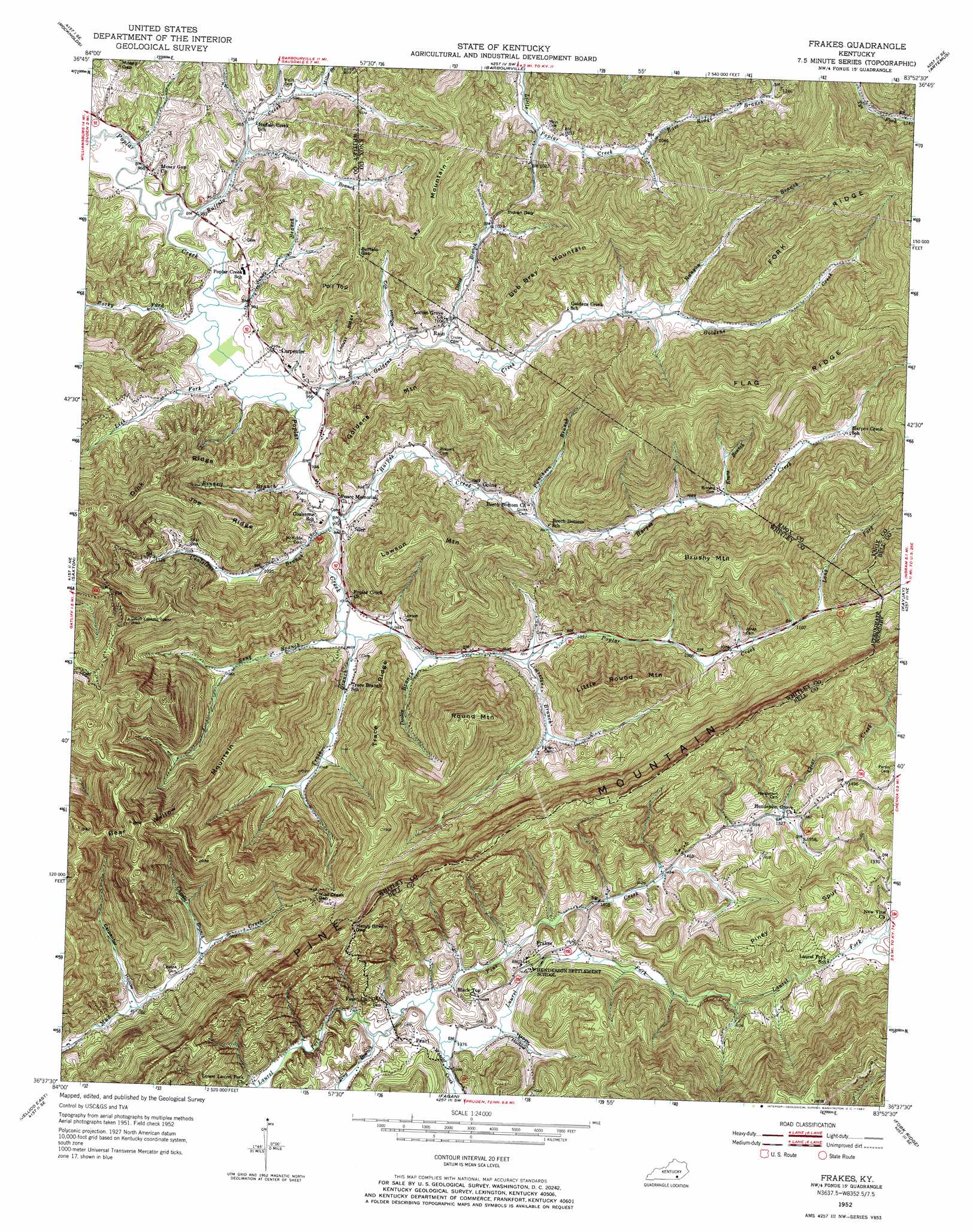
Frakes Topo Map Kentucky
To zoom in, hover over the map of Frakes
USGS Topo Quad 36083f8 - 1:24,000 scale
| Topo Map Name: | Frakes |
| USGS Topo Quad ID: | 36083f8 |
| Print Size: | ca. 21 1/4" wide x 27" high |
| Southeast Coordinates: | 36.625° N latitude / 83.875° W longitude |
| Map Center Coordinates: | 36.6875° N latitude / 83.9375° W longitude |
| U.S. State: | KY |
| Filename: | o36083f8.jpg |
| Download Map JPG Image: | Frakes topo map 1:24,000 scale |
| Map Type: | Topographic |
| Topo Series: | 7.5´ |
| Map Scale: | 1:24,000 |
| Source of Map Images: | United States Geological Survey (USGS) |
| Alternate Map Versions: |
Frakes KY 1952, updated 1954 Download PDF Buy paper map Frakes KY 1952, updated 1967 Download PDF Buy paper map Frakes KY 2010 Download PDF Buy paper map Frakes KY 2013 Download PDF Buy paper map Frakes KY 2016 Download PDF Buy paper map |
1:24,000 Topo Quads surrounding Frakes
Vox |
Corbin |
Heidrick |
Fount |
Scalf |
Wofford |
Rockholds |
Barbourville |
Artemus |
Pineville |
Williamsburg |
Saxton |
Frakes |
Kayjay |
Middlesboro North |
Jellico West |
Jellico East |
Eagan |
Fork Ridge |
Middlesboro South |
Ivydell |
La Follette |
Well Spring |
Ausmus |
Clouds |
> Back to 36083e1 at 1:100,000 scale
> Back to 36082a1 at 1:250,000 scale
> Back to U.S. Topo Maps home
Frakes topo map: Gazetteer
Frakes: Gaps
Buffalo Gap elevation 440m 1443′Henry Bowlin Gap elevation 602m 1975′
Indian Gap elevation 351m 1151′
Mud Creek Gap elevation 459m 1505′
Frakes: Populated Places
Carpenter elevation 310m 1017′Frakes elevation 454m 1489′
Goins elevation 329m 1079′
Pearl elevation 443m 1453′
Rain elevation 316m 1036′
Siler elevation 298m 977′
Frakes: Post Offices
Anchor Post Office (historical) elevation 413m 1354′Birdseye Post Office (historical) elevation 306m 1003′
Middlepoint Post Office (historical) elevation 322m 1056′
Frakes: Ridges
Dink Ridge elevation 506m 1660′Flag Ridge elevation 586m 1922′
Fork Ridge elevation 598m 1961′
Joe Ridge elevation 472m 1548′
Locust Ridge elevation 366m 1200′
Piney Spur elevation 598m 1961′
Trace Ridge elevation 492m 1614′
Frakes: Streams
Bennett Branch elevation 293m 961′Buffalo Creek elevation 288m 944′
Charlie Branch elevation 361m 1184′
Coalstone Branch elevation 294m 964′
Davis Branch elevation 299m 980′
Doolin Branch elevation 302m 990′
East Ridge Branch elevation 317m 1040′
Evans Branch elevation 328m 1076′
Goldens Creek elevation 293m 961′
Harpes Creek elevation 296m 971′
Jack Branch elevation 377m 1236′
Lick Fork elevation 291m 954′
Limestone Branch elevation 304m 997′
Long Fork elevation 341m 1118′
Miller Branch elevation 305m 1000′
Pine Creek elevation 418m 1371′
Powers Branch elevation 294m 964′
Puncheon Branch elevation 309m 1013′
Rocky Fork elevation 289m 948′
Runyon Branch elevation 320m 1049′
Sandy Branch elevation 290m 951′
Seng Branch elevation 296m 971′
Tiny Branch elevation 414m 1358′
Trace Branch elevation 296m 971′
Wheeler Creek elevation 417m 1368′
Frakes: Summits
Bear Wallow Mountain elevation 655m 2148′Bob Bray Mountain elevation 316m 1036′
Brushy Mountain elevation 585m 1919′
Goldens Mountain elevation 506m 1660′
Lawson Mountain elevation 585m 1919′
Lay Mountain elevation 510m 1673′
Little Round Mountain elevation 504m 1653′
Poll Top elevation 490m 1607′
Round Mountain elevation 599m 1965′
Frakes: Valleys
Carpenter Hollow elevation 351m 1151′Cox Hollow elevation 303m 994′
Happy Hollow elevation 420m 1377′
Frakes digital topo map on disk
Buy this Frakes topo map showing relief, roads, GPS coordinates and other geographical features, as a high-resolution digital map file on DVD:
Western Virginia & Southern West Virginia
Buy digital topo maps: Western Virginia & Southern West Virginia