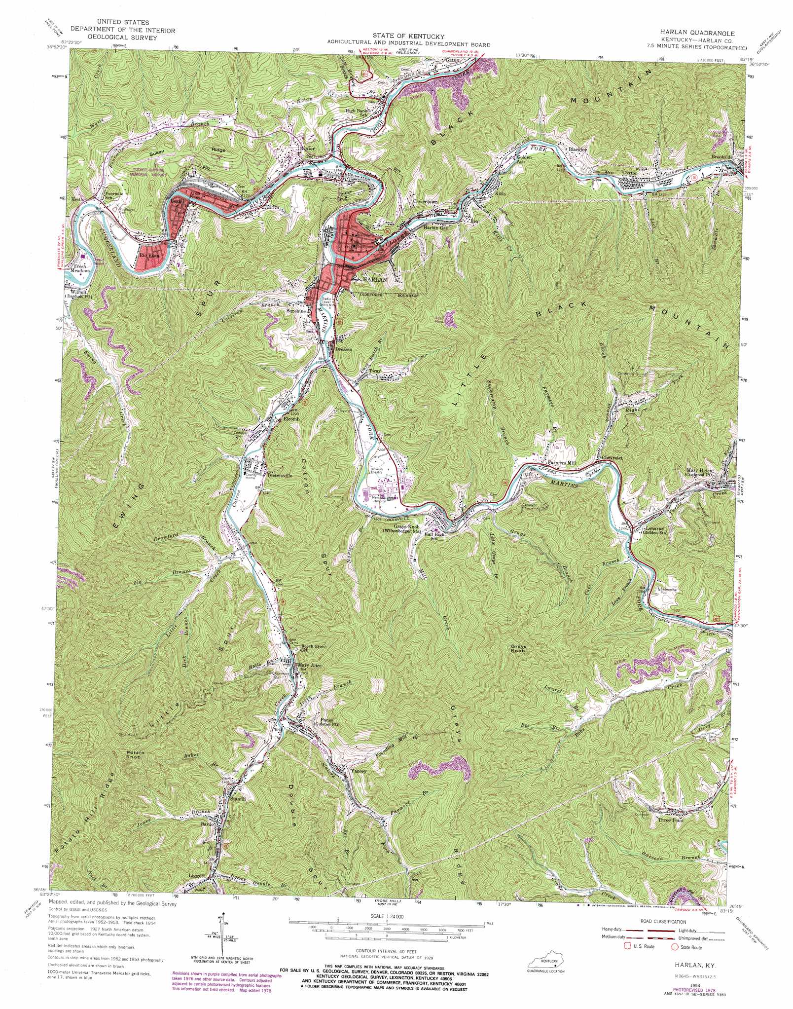
Harlan Topo Map Kentucky
To zoom in, hover over the map of Harlan
USGS Topo Quad 36083g3 - 1:24,000 scale
| Topo Map Name: | Harlan |
| USGS Topo Quad ID: | 36083g3 |
| Print Size: | ca. 21 1/4" wide x 27" high |
| Southeast Coordinates: | 36.75° N latitude / 83.25° W longitude |
| Map Center Coordinates: | 36.8125° N latitude / 83.3125° W longitude |
| U.S. State: | KY |
| Filename: | o36083g3.jpg |
| Download Map JPG Image: | Harlan topo map 1:24,000 scale |
| Map Type: | Topographic |
| Topo Series: | 7.5´ |
| Map Scale: | 1:24,000 |
| Source of Map Images: | United States Geological Survey (USGS) |
| Alternate Map Versions: |
Harlan KY 1954, updated 1956 Download PDF Buy paper map Harlan KY 1954, updated 1967 Download PDF Buy paper map Harlan KY 1954, updated 1977 Download PDF Buy paper map Harlan KY 1954, updated 1978 Download PDF Buy paper map Harlan KY 2010 Download PDF Buy paper map Harlan KY 2013 Download PDF Buy paper map Harlan KY 2016 Download PDF Buy paper map |
1:24,000 Topo Quads surrounding Harlan
Creekville |
Hoskinston |
Cutshin |
Leatherwood |
Tilford |
Beverly |
Helton |
Bledsoe |
Nolansburg |
Louellen |
Balkan |
Wallins Creek |
Harlan |
Evarts |
Pennington Gap |
Varilla |
Ewing |
Rose Hill |
Hubbard Springs |
Ben Hur |
Wheeler |
Coleman Gap |
Back Valley |
Sneedville |
Kyles Ford |
> Back to 36083e1 at 1:100,000 scale
> Back to 36082a1 at 1:250,000 scale
> Back to U.S. Topo Maps home
Harlan topo map: Gazetteer
Harlan: Airports
Tucker-Guthrie Memorial Airport elevation 462m 1515′Harlan: Dams
Martins Fork Dam elevation 389m 1276′Harlan: Flats
Black Bottom elevation 373m 1223′Harlan: Populated Places
Bardo elevation 448m 1469′Baxter elevation 369m 1210′
Blackjoe elevation 392m 1286′
Chevrolet elevation 404m 1325′
Clovertown elevation 359m 1177′
Coxton elevation 371m 1217′
Dressen elevation 382m 1253′
Elcomb elevation 418m 1371′
Farmers Mill elevation 387m 1269′
Fresh Meadows elevation 363m 1190′
Gatun elevation 358m 1174′
Golden Ash elevation 372m 1220′
Harlan elevation 363m 1190′
Harlan Gas elevation 362m 1187′
Keith elevation 349m 1145′
Kitts elevation 380m 1246′
Lenarue elevation 382m 1253′
Liggett elevation 456m 1496′
Loyall elevation 358m 1174′
Mary Alice elevation 403m 1322′
Mary Helen elevation 414m 1358′
Pansy elevation 416m 1364′
Rex elevation 403m 1322′
Rio Vista elevation 356m 1167′
Stanfill elevation 435m 1427′
Sunshine elevation 361m 1184′
Teetersville elevation 383m 1256′
Three Point elevation 438m 1437′
Tin Can Alley (historical) elevation 375m 1230′
Tway elevation 401m 1315′
Yancey elevation 464m 1522′
Harlan: Post Offices
Bardo Post Office (historical) elevation 439m 1440′Blackjoe Post Office (historical) elevation 390m 1279′
Brookside Post Office (historical) elevation 374m 1227′
Cello Post Office (historical) elevation 378m 1240′
Chevrolet Post Office (historical) elevation 376m 1233′
Coal Good Post Office (historical) elevation 434m 1423′
Coalgood Post Office elevation 414m 1358′
Coxton Post Office (historical) elevation 370m 1213′
Elcomb Post Office (historical) elevation 364m 1194′
George Post Office (historical) elevation 378m 1240′
Grays Knob Post Office (historical) elevation 372m 1220′
Gulston Post Office (historical) elevation 416m 1364′
Keith Post Office (historical) elevation 351m 1151′
Kitts Post Office (historical) elevation 379m 1243′
Lenarue Post Office (historical) elevation 397m 1302′
Liggett Post Office (historical) elevation 450m 1476′
Sunshine Post Office (historical) elevation 363m 1190′
Tettersville Post Office (historical) elevation 373m 1223′
Three Point Post Office (historical) elevation 413m 1354′
Tway Post Office (historical) elevation 369m 1210′
White Star Post Office (historical) elevation 389m 1276′
Yancey Post Office (historical) elevation 452m 1482′
Harlan: Reservoirs
Martins Fork Lake elevation 388m 1272′Harlan: Ridges
Catron Spur elevation 562m 1843′Double Spur elevation 877m 2877′
Ewing Spur elevation 679m 2227′
Grays Ridge elevation 961m 3152′
Little Spur elevation 714m 2342′
Potato Hill Ridge elevation 878m 2880′
Sukey Ridge elevation 452m 1482′
Harlan: Streams
Baker Branch elevation 426m 1397′Baker Branch elevation 359m 1177′
Bee Branch elevation 468m 1535′
Bee Branch elevation 474m 1555′
Big Branch elevation 403m 1322′
Bob Day Branch elevation 361m 1184′
Carr Branch elevation 376m 1233′
Catron Creek elevation 361m 1184′
Clover Fork Cumberland River elevation 354m 1161′
Coldiron Branch elevation 356m 1167′
Crawford Branch elevation 394m 1292′
Dave Smith Branch elevation 361m 1184′
Dick Branch elevation 424m 1391′
Enoch Branch elevation 375m 1230′
Ewing Creek elevation 347m 1138′
Farmers Branch elevation 490m 1607′
Farmers Branch elevation 374m 1227′
Fourmile Branch elevation 350m 1148′
French Branch elevation 357m 1171′
Grays Branch elevation 368m 1207′
Halls Branch elevation 393m 1289′
Hensely Branch elevation 372m 1220′
Irvin Branch elevation 407m 1335′
Jones Branch elevation 439m 1440′
Kitts Creek elevation 369m 1210′
Laurel Branch elevation 456m 1496′
Laurel Branch elevation 376m 1233′
Left Fork Turtle Creek elevation 414m 1358′
Lick Branch elevation 374m 1227′
Lick Branch elevation 360m 1181′
Little Creek elevation 383m 1256′
Little Grays Branch elevation 372m 1220′
Lowe Branch elevation 378m 1240′
Lower Double Branch elevation 450m 1476′
Martins Fork Cumberland River elevation 353m 1158′
Middle Fork elevation 397m 1302′
Mill Creek elevation 376m 1233′
Napier Branch elevation 366m 1200′
Nolan Branch elevation 395m 1295′
Poor Fork Cumberland River elevation 350m 1148′
Pounding Mill Branch elevation 441m 1446′
Right Fork Enoch Branch elevation 416m 1364′
Sam Howard Branch elevation 376m 1233′
Shumate Branch elevation 374m 1227′
Slaters Fork elevation 411m 1348′
Sugarcamp Branch elevation 377m 1236′
Turtle Creek elevation 378m 1240′
Upper Double Branch elevation 451m 1479′
Harlan: Summits
Bobs Spur elevation 635m 2083′Grays Knob elevation 973m 3192′
Howard Cliff elevation 367m 1204′
Potato Knob elevation 941m 3087′
Harlan: Valleys
Ranson Hollow elevation 355m 1164′Spicewood Hollow (historical) elevation 366m 1200′
Harlan digital topo map on disk
Buy this Harlan topo map showing relief, roads, GPS coordinates and other geographical features, as a high-resolution digital map file on DVD:
Western Virginia & Southern West Virginia
Buy digital topo maps: Western Virginia & Southern West Virginia